{"title":"可实现的可达性:利用高分辨率实时数据评估公共交通可达性的可靠性。","authors":"Luyu Liu, Adam Porr, Harvey J Miller","doi":"10.1007/s10109-022-00382-w","DOIUrl":null,"url":null,"abstract":"<p><p>The widespread availability of high spatial and temporal resolution public transit data is improving the measurement and analysis of public transit-based accessibility to crucial community resources such as jobs and health care. A common approach is leveraging transit route and schedule data published by transit agencies. However, this often results in accessibility overestimations due to endemic delays due to traffic and incidents in bus systems. Retrospective real-time accessibility measures calculated using real-time bus location data attempt to reduce overestimation by capturing the actual performance of the transit system. These measures also overestimate accessibility since they assume that riders had perfect information on systems operations as they occurred. In this paper, we introduce <i>realizable real-time accessibility</i> based on space-time prisms as a more conservative and realistic measure. We, moreover, define <i>accessibility unreliability</i> to measure overestimation of schedule-based and retrospective accessibility measures. Using high-resolution General Transit Feed Specification real-time data, we conduct a case study in the Central Ohio Transit Authority bus system in Columbus, Ohio, USA. Our results prove that realizable accessibility is the most conservative of the three accessibility measures. We also explore the spatial and temporal patterns in the unreliability of both traditional measures. These patterns are consistent with prior findings of the spatial and temporal patterns of bus delays and risk of missing transfers. Realizable accessibility is a more practical, conservative, and robust measure to guide transit planning.</p>","PeriodicalId":47245,"journal":{"name":"Journal of Geographical Systems","volume":null,"pages":null},"PeriodicalIF":2.8000,"publicationDate":"2022-05-20","publicationTypes":"Journal Article","fieldsOfStudy":null,"isOpenAccess":false,"openAccessPdf":"https://www.ncbi.nlm.nih.gov/pmc/articles/PMC9122481/pdf/","citationCount":"0","resultStr":"{\"title\":\"Realizable accessibility: evaluating the reliability of public transit accessibility using high-resolution real-time data.\",\"authors\":\"Luyu Liu, Adam Porr, Harvey J Miller\",\"doi\":\"10.1007/s10109-022-00382-w\",\"DOIUrl\":null,\"url\":null,\"abstract\":\"<p><p>The widespread availability of high spatial and temporal resolution public transit data is improving the measurement and analysis of public transit-based accessibility to crucial community resources such as jobs and health care. A common approach is leveraging transit route and schedule data published by transit agencies. However, this often results in accessibility overestimations due to endemic delays due to traffic and incidents in bus systems. Retrospective real-time accessibility measures calculated using real-time bus location data attempt to reduce overestimation by capturing the actual performance of the transit system. These measures also overestimate accessibility since they assume that riders had perfect information on systems operations as they occurred. In this paper, we introduce <i>realizable real-time accessibility</i> based on space-time prisms as a more conservative and realistic measure. We, moreover, define <i>accessibility unreliability</i> to measure overestimation of schedule-based and retrospective accessibility measures. Using high-resolution General Transit Feed Specification real-time data, we conduct a case study in the Central Ohio Transit Authority bus system in Columbus, Ohio, USA. Our results prove that realizable accessibility is the most conservative of the three accessibility measures. We also explore the spatial and temporal patterns in the unreliability of both traditional measures. These patterns are consistent with prior findings of the spatial and temporal patterns of bus delays and risk of missing transfers. Realizable accessibility is a more practical, conservative, and robust measure to guide transit planning.</p>\",\"PeriodicalId\":47245,\"journal\":{\"name\":\"Journal of Geographical Systems\",\"volume\":null,\"pages\":null},\"PeriodicalIF\":2.8000,\"publicationDate\":\"2022-05-20\",\"publicationTypes\":\"Journal Article\",\"fieldsOfStudy\":null,\"isOpenAccess\":false,\"openAccessPdf\":\"https://www.ncbi.nlm.nih.gov/pmc/articles/PMC9122481/pdf/\",\"citationCount\":\"0\",\"resultStr\":null,\"platform\":\"Semanticscholar\",\"paperid\":null,\"PeriodicalName\":\"Journal of Geographical Systems\",\"FirstCategoryId\":\"89\",\"ListUrlMain\":\"https://doi.org/10.1007/s10109-022-00382-w\",\"RegionNum\":3,\"RegionCategory\":\"地球科学\",\"ArticlePicture\":[],\"TitleCN\":null,\"AbstractTextCN\":null,\"PMCID\":null,\"EPubDate\":\"\",\"PubModel\":\"\",\"JCR\":\"Q1\",\"JCRName\":\"GEOGRAPHY\",\"Score\":null,\"Total\":0}","platform":"Semanticscholar","paperid":null,"PeriodicalName":"Journal of Geographical Systems","FirstCategoryId":"89","ListUrlMain":"https://doi.org/10.1007/s10109-022-00382-w","RegionNum":3,"RegionCategory":"地球科学","ArticlePicture":[],"TitleCN":null,"AbstractTextCN":null,"PMCID":null,"EPubDate":"","PubModel":"","JCR":"Q1","JCRName":"GEOGRAPHY","Score":null,"Total":0}
Realizable accessibility: evaluating the reliability of public transit accessibility using high-resolution real-time data.
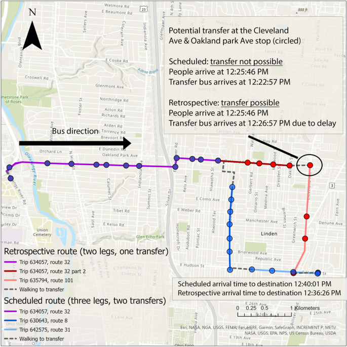
The widespread availability of high spatial and temporal resolution public transit data is improving the measurement and analysis of public transit-based accessibility to crucial community resources such as jobs and health care. A common approach is leveraging transit route and schedule data published by transit agencies. However, this often results in accessibility overestimations due to endemic delays due to traffic and incidents in bus systems. Retrospective real-time accessibility measures calculated using real-time bus location data attempt to reduce overestimation by capturing the actual performance of the transit system. These measures also overestimate accessibility since they assume that riders had perfect information on systems operations as they occurred. In this paper, we introduce realizable real-time accessibility based on space-time prisms as a more conservative and realistic measure. We, moreover, define accessibility unreliability to measure overestimation of schedule-based and retrospective accessibility measures. Using high-resolution General Transit Feed Specification real-time data, we conduct a case study in the Central Ohio Transit Authority bus system in Columbus, Ohio, USA. Our results prove that realizable accessibility is the most conservative of the three accessibility measures. We also explore the spatial and temporal patterns in the unreliability of both traditional measures. These patterns are consistent with prior findings of the spatial and temporal patterns of bus delays and risk of missing transfers. Realizable accessibility is a more practical, conservative, and robust measure to guide transit planning.
期刊介绍:
The Journal of Geographical Systems (JGS) is an interdisciplinary peer-reviewed academic journal that aims to encourage and promote high-quality scholarship on new theoretical or empirical results, models and methods in the social sciences. It solicits original papers with a spatial dimension that can be of interest to social scientists. Coverage includes regional science, economic geography, spatial economics, regional and urban economics, GIScience and GeoComputation, big data and machine learning. Spatial analysis, spatial econometrics and statistics are strongly represented.
One of the distinctive features of the journal is its concern for the interface between modeling, statistical techniques and spatial issues in a wide spectrum of related fields. An important goal of the journal is to encourage a spatial perspective in the social sciences that emphasizes geographical space as a relevant dimension to our understanding of socio-economic phenomena.
Contributions should be of high-quality, be technically well-crafted, make a substantial contribution to the subject and contain a spatial dimension. The journal also aims to publish, review and survey articles that make recent theoretical and methodological developments more readily accessible to the audience of the journal.
All papers of this journal have undergone rigorous double-blind peer-review, based on initial editor screening and with at least two peer reviewers.
Officially cited as J Geogr Syst
 求助内容:
求助内容: 应助结果提醒方式:


