A. J. Lindsey, B. Allred, L. R. Martinez, Greg Rouse, P. R. Thomison
{"title":"利用无折叠飞行器图像量化玉米根系倒伏损伤","authors":"A. J. Lindsey, B. Allred, L. R. Martinez, Greg Rouse, P. R. Thomison","doi":"10.1002/cft2.20241","DOIUrl":null,"url":null,"abstract":"<p>Accurate quantification of damage associated with root lodging events can help producers assess damage, predict potential yield losses, and help understand potential issues with grain quality that may arise post-harvest (i.e., kernel weight reductions, premature germination on the ear, or vivipary). The objective of this research was to utilize imagery from an uncrewed aerial vehicle (UAV) to accurately quantify crop canopy height, grain yield, and identify trends in imagery data associated with grain quality after root lodging was imposed at multiple growth stages. Simulated corn (<i>Zea mays</i> L.) root lodging experiments were conducted in 2018 and 2019 with lodging treatments applied at two vegetative or two reproductive growth stages (V10, V14, VT/R1, and R3). At dough stage (R4), visible-color and multispectral images were collected from each trial. Bare fields were also flown in February to obtain baseline elevation data. Imagery data were used to develop digital surface model (DSM) images and used to calculate indices of normalized difference red edge (NDRE) and normalized difference vegetation index (NDVI). Individual datapoints within each experimental plot were extracted from the imagery files and were compared to ground-truth measurements. The DSM height values were similar to actual measured heights for most lodging treatments (Adj. <i>R</i><sup>2</sup> = .957). Both NDRE and NDVI exhibited linear trends with height and quality parameters (Adj. <i>R</i><sup>2</sup> = .25–.54), though yield patterns were best described using a quadratic model (Adj. <i>R</i><sup>2</sup> = .42–.60). These procedures hold utility in accurately quantifying canopy height following a root lodging event and hold promise in helping consultants identify yield and grain quality reductions associated with root lodging.</p>","PeriodicalId":10931,"journal":{"name":"Crop, Forage and Turfgrass Management","volume":"9 2","pages":""},"PeriodicalIF":0.8000,"publicationDate":"2023-07-02","publicationTypes":"Journal Article","fieldsOfStudy":null,"isOpenAccess":false,"openAccessPdf":"https://onlinelibrary.wiley.com/doi/epdf/10.1002/cft2.20241","citationCount":"0","resultStr":"{\"title\":\"Quantification of root lodging damage in corn using uncrewed aerial vehicle imagery\",\"authors\":\"A. J. Lindsey, B. Allred, L. R. Martinez, Greg Rouse, P. R. Thomison\",\"doi\":\"10.1002/cft2.20241\",\"DOIUrl\":null,\"url\":null,\"abstract\":\"<p>Accurate quantification of damage associated with root lodging events can help producers assess damage, predict potential yield losses, and help understand potential issues with grain quality that may arise post-harvest (i.e., kernel weight reductions, premature germination on the ear, or vivipary). The objective of this research was to utilize imagery from an uncrewed aerial vehicle (UAV) to accurately quantify crop canopy height, grain yield, and identify trends in imagery data associated with grain quality after root lodging was imposed at multiple growth stages. Simulated corn (<i>Zea mays</i> L.) root lodging experiments were conducted in 2018 and 2019 with lodging treatments applied at two vegetative or two reproductive growth stages (V10, V14, VT/R1, and R3). At dough stage (R4), visible-color and multispectral images were collected from each trial. Bare fields were also flown in February to obtain baseline elevation data. Imagery data were used to develop digital surface model (DSM) images and used to calculate indices of normalized difference red edge (NDRE) and normalized difference vegetation index (NDVI). Individual datapoints within each experimental plot were extracted from the imagery files and were compared to ground-truth measurements. The DSM height values were similar to actual measured heights for most lodging treatments (Adj. <i>R</i><sup>2</sup> = .957). Both NDRE and NDVI exhibited linear trends with height and quality parameters (Adj. <i>R</i><sup>2</sup> = .25–.54), though yield patterns were best described using a quadratic model (Adj. <i>R</i><sup>2</sup> = .42–.60). These procedures hold utility in accurately quantifying canopy height following a root lodging event and hold promise in helping consultants identify yield and grain quality reductions associated with root lodging.</p>\",\"PeriodicalId\":10931,\"journal\":{\"name\":\"Crop, Forage and Turfgrass Management\",\"volume\":\"9 2\",\"pages\":\"\"},\"PeriodicalIF\":0.8000,\"publicationDate\":\"2023-07-02\",\"publicationTypes\":\"Journal Article\",\"fieldsOfStudy\":null,\"isOpenAccess\":false,\"openAccessPdf\":\"https://onlinelibrary.wiley.com/doi/epdf/10.1002/cft2.20241\",\"citationCount\":\"0\",\"resultStr\":null,\"platform\":\"Semanticscholar\",\"paperid\":null,\"PeriodicalName\":\"Crop, Forage and Turfgrass Management\",\"FirstCategoryId\":\"1085\",\"ListUrlMain\":\"https://onlinelibrary.wiley.com/doi/10.1002/cft2.20241\",\"RegionNum\":0,\"RegionCategory\":null,\"ArticlePicture\":[],\"TitleCN\":null,\"AbstractTextCN\":null,\"PMCID\":null,\"EPubDate\":\"\",\"PubModel\":\"\",\"JCR\":\"Q3\",\"JCRName\":\"AGRONOMY\",\"Score\":null,\"Total\":0}","platform":"Semanticscholar","paperid":null,"PeriodicalName":"Crop, Forage and Turfgrass Management","FirstCategoryId":"1085","ListUrlMain":"https://onlinelibrary.wiley.com/doi/10.1002/cft2.20241","RegionNum":0,"RegionCategory":null,"ArticlePicture":[],"TitleCN":null,"AbstractTextCN":null,"PMCID":null,"EPubDate":"","PubModel":"","JCR":"Q3","JCRName":"AGRONOMY","Score":null,"Total":0}
Quantification of root lodging damage in corn using uncrewed aerial vehicle imagery
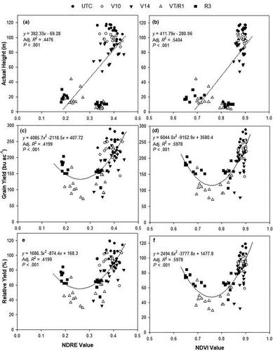
Accurate quantification of damage associated with root lodging events can help producers assess damage, predict potential yield losses, and help understand potential issues with grain quality that may arise post-harvest (i.e., kernel weight reductions, premature germination on the ear, or vivipary). The objective of this research was to utilize imagery from an uncrewed aerial vehicle (UAV) to accurately quantify crop canopy height, grain yield, and identify trends in imagery data associated with grain quality after root lodging was imposed at multiple growth stages. Simulated corn (Zea mays L.) root lodging experiments were conducted in 2018 and 2019 with lodging treatments applied at two vegetative or two reproductive growth stages (V10, V14, VT/R1, and R3). At dough stage (R4), visible-color and multispectral images were collected from each trial. Bare fields were also flown in February to obtain baseline elevation data. Imagery data were used to develop digital surface model (DSM) images and used to calculate indices of normalized difference red edge (NDRE) and normalized difference vegetation index (NDVI). Individual datapoints within each experimental plot were extracted from the imagery files and were compared to ground-truth measurements. The DSM height values were similar to actual measured heights for most lodging treatments (Adj. R2 = .957). Both NDRE and NDVI exhibited linear trends with height and quality parameters (Adj. R2 = .25–.54), though yield patterns were best described using a quadratic model (Adj. R2 = .42–.60). These procedures hold utility in accurately quantifying canopy height following a root lodging event and hold promise in helping consultants identify yield and grain quality reductions associated with root lodging.
期刊介绍:
Crop, Forage & Turfgrass Management is a peer-reviewed, international, electronic journal covering all aspects of applied crop, forage and grazinglands, and turfgrass management. The journal serves the professions related to the management of crops, forages and grazinglands, and turfgrass by publishing research, briefs, reviews, perspectives, and diagnostic and management guides that are beneficial to researchers, practitioners, educators, and industry representatives.

 求助内容:
求助内容: 应助结果提醒方式:


