Sudhanshu Raghubanshi, Ritesh Agrawal, A. S. Rajawat, D. Ram Rajak
{"title":"基于目标分类技术的多传感器土地退化过程半自动提取","authors":"Sudhanshu Raghubanshi, Ritesh Agrawal, A. S. Rajawat, D. Ram Rajak","doi":"10.1007/s12518-023-00503-0","DOIUrl":null,"url":null,"abstract":"<div><h2>Abstract\n</h2><div><p>A semi-automated method has been developed for the extraction of land degradation processes using multi sensor data by applying an object-based classification. The object-based approach creates homogenous objects, which is the key component of this classification. The study utilized optical satellite (Landsat-8), microwave (RISAT-1, SAR) and Cartosat-1 digital elevation model (DEM) over Kanpur Dehat district, Uttar Pradesh, and Surendranagar district, Gujarat, India. The objects were created using Shepherd segmentation algorithm. Normalized difference vegetation index (NDVI) was used to classify the degraded and no apparent degradation (NAD) objects based on the three seasons (rabi, summer, and kharif) Landsat-8 bands. Degraded objects were further classified into salinity, forest water erosion, and water logging using brightness index based on Landsat-8, proximity analysis near the river channel using RISAT-1, and low-lying area using DEM, respectively. The digitally generated results were validated with manual digitized desertification status maps (DSM) published by Space Applications Centre, Ahmedabad, India. The overall accuracy and kappa coefficient for Kanpur Dehat and Surendranagar districts were found 84.67%, 0.79 and 72.33%, 0.60, respectively. This study was carried out based on integrated analysis of different satellites (optical, microwave, and DEM). The advantage of newly designed framework offers less chance of mixing and narrowing down of the area for further classification with better accuracy. The developed framework is based on analytical approach, which was tested and implemented in the Python environment with efficient computing power. The study illustrates that the developed approach is independent of climatic-topographic conditions and executed over pilot study sites, which could be extended over larger regions of the land use/land cover for land degradation mapping.</p></div></div>","PeriodicalId":46286,"journal":{"name":"Applied Geomatics","volume":null,"pages":null},"PeriodicalIF":2.3000,"publicationDate":"2023-03-18","publicationTypes":"Journal Article","fieldsOfStudy":null,"isOpenAccess":false,"openAccessPdf":"https://link.springer.com/content/pdf/10.1007/s12518-023-00503-0.pdf","citationCount":"0","resultStr":"{\"title\":\"Semi-automatic extraction of land degradation processes using multi sensor data by applying object based classification technique\",\"authors\":\"Sudhanshu Raghubanshi, Ritesh Agrawal, A. S. Rajawat, D. Ram Rajak\",\"doi\":\"10.1007/s12518-023-00503-0\",\"DOIUrl\":null,\"url\":null,\"abstract\":\"<div><h2>Abstract\\n</h2><div><p>A semi-automated method has been developed for the extraction of land degradation processes using multi sensor data by applying an object-based classification. The object-based approach creates homogenous objects, which is the key component of this classification. The study utilized optical satellite (Landsat-8), microwave (RISAT-1, SAR) and Cartosat-1 digital elevation model (DEM) over Kanpur Dehat district, Uttar Pradesh, and Surendranagar district, Gujarat, India. The objects were created using Shepherd segmentation algorithm. Normalized difference vegetation index (NDVI) was used to classify the degraded and no apparent degradation (NAD) objects based on the three seasons (rabi, summer, and kharif) Landsat-8 bands. Degraded objects were further classified into salinity, forest water erosion, and water logging using brightness index based on Landsat-8, proximity analysis near the river channel using RISAT-1, and low-lying area using DEM, respectively. The digitally generated results were validated with manual digitized desertification status maps (DSM) published by Space Applications Centre, Ahmedabad, India. The overall accuracy and kappa coefficient for Kanpur Dehat and Surendranagar districts were found 84.67%, 0.79 and 72.33%, 0.60, respectively. This study was carried out based on integrated analysis of different satellites (optical, microwave, and DEM). The advantage of newly designed framework offers less chance of mixing and narrowing down of the area for further classification with better accuracy. The developed framework is based on analytical approach, which was tested and implemented in the Python environment with efficient computing power. The study illustrates that the developed approach is independent of climatic-topographic conditions and executed over pilot study sites, which could be extended over larger regions of the land use/land cover for land degradation mapping.</p></div></div>\",\"PeriodicalId\":46286,\"journal\":{\"name\":\"Applied Geomatics\",\"volume\":null,\"pages\":null},\"PeriodicalIF\":2.3000,\"publicationDate\":\"2023-03-18\",\"publicationTypes\":\"Journal Article\",\"fieldsOfStudy\":null,\"isOpenAccess\":false,\"openAccessPdf\":\"https://link.springer.com/content/pdf/10.1007/s12518-023-00503-0.pdf\",\"citationCount\":\"0\",\"resultStr\":null,\"platform\":\"Semanticscholar\",\"paperid\":null,\"PeriodicalName\":\"Applied Geomatics\",\"FirstCategoryId\":\"1085\",\"ListUrlMain\":\"https://link.springer.com/article/10.1007/s12518-023-00503-0\",\"RegionNum\":0,\"RegionCategory\":null,\"ArticlePicture\":[],\"TitleCN\":null,\"AbstractTextCN\":null,\"PMCID\":null,\"EPubDate\":\"\",\"PubModel\":\"\",\"JCR\":\"Q2\",\"JCRName\":\"REMOTE SENSING\",\"Score\":null,\"Total\":0}","platform":"Semanticscholar","paperid":null,"PeriodicalName":"Applied Geomatics","FirstCategoryId":"1085","ListUrlMain":"https://link.springer.com/article/10.1007/s12518-023-00503-0","RegionNum":0,"RegionCategory":null,"ArticlePicture":[],"TitleCN":null,"AbstractTextCN":null,"PMCID":null,"EPubDate":"","PubModel":"","JCR":"Q2","JCRName":"REMOTE SENSING","Score":null,"Total":0}
Semi-automatic extraction of land degradation processes using multi sensor data by applying object based classification technique
Abstract
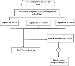
A semi-automated method has been developed for the extraction of land degradation processes using multi sensor data by applying an object-based classification. The object-based approach creates homogenous objects, which is the key component of this classification. The study utilized optical satellite (Landsat-8), microwave (RISAT-1, SAR) and Cartosat-1 digital elevation model (DEM) over Kanpur Dehat district, Uttar Pradesh, and Surendranagar district, Gujarat, India. The objects were created using Shepherd segmentation algorithm. Normalized difference vegetation index (NDVI) was used to classify the degraded and no apparent degradation (NAD) objects based on the three seasons (rabi, summer, and kharif) Landsat-8 bands. Degraded objects were further classified into salinity, forest water erosion, and water logging using brightness index based on Landsat-8, proximity analysis near the river channel using RISAT-1, and low-lying area using DEM, respectively. The digitally generated results were validated with manual digitized desertification status maps (DSM) published by Space Applications Centre, Ahmedabad, India. The overall accuracy and kappa coefficient for Kanpur Dehat and Surendranagar districts were found 84.67%, 0.79 and 72.33%, 0.60, respectively. This study was carried out based on integrated analysis of different satellites (optical, microwave, and DEM). The advantage of newly designed framework offers less chance of mixing and narrowing down of the area for further classification with better accuracy. The developed framework is based on analytical approach, which was tested and implemented in the Python environment with efficient computing power. The study illustrates that the developed approach is independent of climatic-topographic conditions and executed over pilot study sites, which could be extended over larger regions of the land use/land cover for land degradation mapping.
期刊介绍:
Applied Geomatics (AGMJ) is the official journal of SIFET the Italian Society of Photogrammetry and Topography and covers all aspects and information on scientific and technical advances in the geomatics sciences. The Journal publishes innovative contributions in geomatics applications ranging from the integration of instruments, methodologies and technologies and their use in the environmental sciences, engineering and other natural sciences.
The areas of interest include many research fields such as: remote sensing, close range and videometric photogrammetry, image analysis, digital mapping, land and geographic information systems, geographic information science, integrated geodesy, spatial data analysis, heritage recording; network adjustment and numerical processes. Furthermore, Applied Geomatics is open to articles from all areas of deformation measurements and analysis, structural engineering, mechanical engineering and all trends in earth and planetary survey science and space technology. The Journal also contains notices of conferences and international workshops, industry news, and information on new products. It provides a useful forum for professional and academic scientists involved in geomatics science and technology.
Information on Open Research Funding and Support may be found here: https://www.springernature.com/gp/open-research/institutional-agreements

 求助内容:
求助内容: 应助结果提醒方式:


