{"title":"利用来自Sentinel-2图像的波段比率在干旱期探测建成区(阿尔及利亚东北部)","authors":"Khaled Rouibah","doi":"10.1007/s12518-023-00513-y","DOIUrl":null,"url":null,"abstract":"<div><p>In this research, the band rationing technique was used to expect accurate detection of built-up in a dry period over El-Eulma city (North-East Algeria). In this context, the VNIR Sentinel-2 bands were examined statistically over the study area. Consequently, two bands ratio (BR) which are mainly the blue-near-infrared (B2/B8) and the green-near-infrared (B3/B8), were selected to be used singly as input data, for the binarization process via the use of Otsu method. To evaluate the approach and find the optimal bands ratio for built-up detection in the dry period, the accuracy assessment was done, using the high-resolution Google Earth images as a reference map. Also, the results obtained were compared to the both built-up mapping resulting from the support vector machine (SVM) classification and built-up area index (BAI). The findings showed that the BR (B2/B8) works approximately similar to the SVM classification result. In contrast, the BR (B2/B8) works better than the BR (B3/B8) and BAI index; the overall accuracy (OA) and kappa coefficient of the first BR (B2/B8) are about 92,33% and 80,81%, respectively. In contrast, the (OA) and kappa coefficient of the second BR (B3/B8) are about 90,97% and 76,72% respectively, Meanwhile, the (OA) of the BAI index is about 89.33% and its kappa coefficient is about 74,80%. Therefore, the results present BR (B2/B8) as a simple automatic technique that could be suitable for mapping cities accurately in a dry climate, for better land use planning.</p></div>","PeriodicalId":46286,"journal":{"name":"Applied Geomatics","volume":"15 2","pages":"473 - 482"},"PeriodicalIF":2.3000,"publicationDate":"2023-06-09","publicationTypes":"Journal Article","fieldsOfStudy":null,"isOpenAccess":false,"openAccessPdf":"","citationCount":"0","resultStr":"{\"title\":\"The use of bands ratio derived from Sentinel-2 imagery to detect built-up area in the dry period (North-East Algeria)\",\"authors\":\"Khaled Rouibah\",\"doi\":\"10.1007/s12518-023-00513-y\",\"DOIUrl\":null,\"url\":null,\"abstract\":\"<div><p>In this research, the band rationing technique was used to expect accurate detection of built-up in a dry period over El-Eulma city (North-East Algeria). In this context, the VNIR Sentinel-2 bands were examined statistically over the study area. Consequently, two bands ratio (BR) which are mainly the blue-near-infrared (B2/B8) and the green-near-infrared (B3/B8), were selected to be used singly as input data, for the binarization process via the use of Otsu method. To evaluate the approach and find the optimal bands ratio for built-up detection in the dry period, the accuracy assessment was done, using the high-resolution Google Earth images as a reference map. Also, the results obtained were compared to the both built-up mapping resulting from the support vector machine (SVM) classification and built-up area index (BAI). The findings showed that the BR (B2/B8) works approximately similar to the SVM classification result. In contrast, the BR (B2/B8) works better than the BR (B3/B8) and BAI index; the overall accuracy (OA) and kappa coefficient of the first BR (B2/B8) are about 92,33% and 80,81%, respectively. In contrast, the (OA) and kappa coefficient of the second BR (B3/B8) are about 90,97% and 76,72% respectively, Meanwhile, the (OA) of the BAI index is about 89.33% and its kappa coefficient is about 74,80%. Therefore, the results present BR (B2/B8) as a simple automatic technique that could be suitable for mapping cities accurately in a dry climate, for better land use planning.</p></div>\",\"PeriodicalId\":46286,\"journal\":{\"name\":\"Applied Geomatics\",\"volume\":\"15 2\",\"pages\":\"473 - 482\"},\"PeriodicalIF\":2.3000,\"publicationDate\":\"2023-06-09\",\"publicationTypes\":\"Journal Article\",\"fieldsOfStudy\":null,\"isOpenAccess\":false,\"openAccessPdf\":\"\",\"citationCount\":\"0\",\"resultStr\":null,\"platform\":\"Semanticscholar\",\"paperid\":null,\"PeriodicalName\":\"Applied Geomatics\",\"FirstCategoryId\":\"1085\",\"ListUrlMain\":\"https://link.springer.com/article/10.1007/s12518-023-00513-y\",\"RegionNum\":0,\"RegionCategory\":null,\"ArticlePicture\":[],\"TitleCN\":null,\"AbstractTextCN\":null,\"PMCID\":null,\"EPubDate\":\"\",\"PubModel\":\"\",\"JCR\":\"Q2\",\"JCRName\":\"REMOTE SENSING\",\"Score\":null,\"Total\":0}","platform":"Semanticscholar","paperid":null,"PeriodicalName":"Applied Geomatics","FirstCategoryId":"1085","ListUrlMain":"https://link.springer.com/article/10.1007/s12518-023-00513-y","RegionNum":0,"RegionCategory":null,"ArticlePicture":[],"TitleCN":null,"AbstractTextCN":null,"PMCID":null,"EPubDate":"","PubModel":"","JCR":"Q2","JCRName":"REMOTE SENSING","Score":null,"Total":0}
The use of bands ratio derived from Sentinel-2 imagery to detect built-up area in the dry period (North-East Algeria)
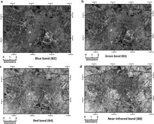
In this research, the band rationing technique was used to expect accurate detection of built-up in a dry period over El-Eulma city (North-East Algeria). In this context, the VNIR Sentinel-2 bands were examined statistically over the study area. Consequently, two bands ratio (BR) which are mainly the blue-near-infrared (B2/B8) and the green-near-infrared (B3/B8), were selected to be used singly as input data, for the binarization process via the use of Otsu method. To evaluate the approach and find the optimal bands ratio for built-up detection in the dry period, the accuracy assessment was done, using the high-resolution Google Earth images as a reference map. Also, the results obtained were compared to the both built-up mapping resulting from the support vector machine (SVM) classification and built-up area index (BAI). The findings showed that the BR (B2/B8) works approximately similar to the SVM classification result. In contrast, the BR (B2/B8) works better than the BR (B3/B8) and BAI index; the overall accuracy (OA) and kappa coefficient of the first BR (B2/B8) are about 92,33% and 80,81%, respectively. In contrast, the (OA) and kappa coefficient of the second BR (B3/B8) are about 90,97% and 76,72% respectively, Meanwhile, the (OA) of the BAI index is about 89.33% and its kappa coefficient is about 74,80%. Therefore, the results present BR (B2/B8) as a simple automatic technique that could be suitable for mapping cities accurately in a dry climate, for better land use planning.
期刊介绍:
Applied Geomatics (AGMJ) is the official journal of SIFET the Italian Society of Photogrammetry and Topography and covers all aspects and information on scientific and technical advances in the geomatics sciences. The Journal publishes innovative contributions in geomatics applications ranging from the integration of instruments, methodologies and technologies and their use in the environmental sciences, engineering and other natural sciences.
The areas of interest include many research fields such as: remote sensing, close range and videometric photogrammetry, image analysis, digital mapping, land and geographic information systems, geographic information science, integrated geodesy, spatial data analysis, heritage recording; network adjustment and numerical processes. Furthermore, Applied Geomatics is open to articles from all areas of deformation measurements and analysis, structural engineering, mechanical engineering and all trends in earth and planetary survey science and space technology. The Journal also contains notices of conferences and international workshops, industry news, and information on new products. It provides a useful forum for professional and academic scientists involved in geomatics science and technology.
Information on Open Research Funding and Support may be found here: https://www.springernature.com/gp/open-research/institutional-agreements

 求助内容:
求助内容: 应助结果提醒方式:


