{"title":"遥感和GIS在城市建筑能源建模中的潜力","authors":"Arunim Anand , Chirag Deb","doi":"10.1016/j.enbenv.2023.07.008","DOIUrl":null,"url":null,"abstract":"<div><p>As the world continues to urbanize at an unprecedented rate, the energy demand in cities is rising. Buildings account for over 75% of all the energy consumed in cities and are responsible for over two-thirds of the emissions. Assessment of energy demand in buildings is a highly integrative endeavour, bringing together the interdisciplinary fields of energy and urban studies, along with a host of technical domains namely, geography, engineering, economics, sociology, and planning. In the last decade, several urban building energy modelling tools (UBEMs) have been developed for estimation as well as prediction of energy demand in cities. These models are useful in policymaking as they can evaluate future urban energy scenarios. However, data acquisition for generating the input database for UBEM has been a major challenge. In this review, a comprehensive assessment of the potential of remote sensing and GIS techniques for UBEM has been presented. Firstly, the most common input variables of UBEM have been identified by reviewing recent publications on UBEM and then studies related to the acquisition of data corresponding to these variables have been explored. More than 140 research papers and review articles relevant to remote sensing and GIS applications for building level data extraction in urban areas and UBEM applications have been investigated for this purpose. After going through level of details required for each of the input components of UBEM and studying the possibility of acquiring some of those data using remote sensing, it has been inferred that satellite remote sensing and Unmanned Aerial Vehicles (UAVs) have a strong potential in enhancing the input data space for UBEM but their applicability has been limited. Further, the challenges of the usage of these technologies and the possible solutions have also been presented in this study. It is recommended to utilise the existing methodologies of extracting information from remote sensing and GIS for UBEM, along with newer techniques such as machine learning and artificial intelligence.</p></div>","PeriodicalId":33659,"journal":{"name":"Energy and Built Environment","volume":"5 6","pages":"Pages 957-969"},"PeriodicalIF":0.0000,"publicationDate":"2023-07-23","publicationTypes":"Journal Article","fieldsOfStudy":null,"isOpenAccess":false,"openAccessPdf":"https://www.sciencedirect.com/science/article/pii/S2666123323000685/pdfft?md5=20a069e63d3e87771db75335adfbb817&pid=1-s2.0-S2666123323000685-main.pdf","citationCount":"0","resultStr":"{\"title\":\"The potential of remote sensing and GIS in urban building energy modelling\",\"authors\":\"Arunim Anand , Chirag Deb\",\"doi\":\"10.1016/j.enbenv.2023.07.008\",\"DOIUrl\":null,\"url\":null,\"abstract\":\"<div><p>As the world continues to urbanize at an unprecedented rate, the energy demand in cities is rising. Buildings account for over 75% of all the energy consumed in cities and are responsible for over two-thirds of the emissions. Assessment of energy demand in buildings is a highly integrative endeavour, bringing together the interdisciplinary fields of energy and urban studies, along with a host of technical domains namely, geography, engineering, economics, sociology, and planning. In the last decade, several urban building energy modelling tools (UBEMs) have been developed for estimation as well as prediction of energy demand in cities. These models are useful in policymaking as they can evaluate future urban energy scenarios. However, data acquisition for generating the input database for UBEM has been a major challenge. In this review, a comprehensive assessment of the potential of remote sensing and GIS techniques for UBEM has been presented. Firstly, the most common input variables of UBEM have been identified by reviewing recent publications on UBEM and then studies related to the acquisition of data corresponding to these variables have been explored. More than 140 research papers and review articles relevant to remote sensing and GIS applications for building level data extraction in urban areas and UBEM applications have been investigated for this purpose. After going through level of details required for each of the input components of UBEM and studying the possibility of acquiring some of those data using remote sensing, it has been inferred that satellite remote sensing and Unmanned Aerial Vehicles (UAVs) have a strong potential in enhancing the input data space for UBEM but their applicability has been limited. Further, the challenges of the usage of these technologies and the possible solutions have also been presented in this study. It is recommended to utilise the existing methodologies of extracting information from remote sensing and GIS for UBEM, along with newer techniques such as machine learning and artificial intelligence.</p></div>\",\"PeriodicalId\":33659,\"journal\":{\"name\":\"Energy and Built Environment\",\"volume\":\"5 6\",\"pages\":\"Pages 957-969\"},\"PeriodicalIF\":0.0000,\"publicationDate\":\"2023-07-23\",\"publicationTypes\":\"Journal Article\",\"fieldsOfStudy\":null,\"isOpenAccess\":false,\"openAccessPdf\":\"https://www.sciencedirect.com/science/article/pii/S2666123323000685/pdfft?md5=20a069e63d3e87771db75335adfbb817&pid=1-s2.0-S2666123323000685-main.pdf\",\"citationCount\":\"0\",\"resultStr\":null,\"platform\":\"Semanticscholar\",\"paperid\":null,\"PeriodicalName\":\"Energy and Built Environment\",\"FirstCategoryId\":\"1085\",\"ListUrlMain\":\"https://www.sciencedirect.com/science/article/pii/S2666123323000685\",\"RegionNum\":0,\"RegionCategory\":null,\"ArticlePicture\":[],\"TitleCN\":null,\"AbstractTextCN\":null,\"PMCID\":null,\"EPubDate\":\"\",\"PubModel\":\"\",\"JCR\":\"Q1\",\"JCRName\":\"Engineering\",\"Score\":null,\"Total\":0}","platform":"Semanticscholar","paperid":null,"PeriodicalName":"Energy and Built Environment","FirstCategoryId":"1085","ListUrlMain":"https://www.sciencedirect.com/science/article/pii/S2666123323000685","RegionNum":0,"RegionCategory":null,"ArticlePicture":[],"TitleCN":null,"AbstractTextCN":null,"PMCID":null,"EPubDate":"","PubModel":"","JCR":"Q1","JCRName":"Engineering","Score":null,"Total":0}
The potential of remote sensing and GIS in urban building energy modelling
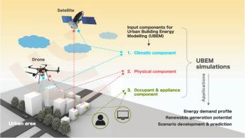
As the world continues to urbanize at an unprecedented rate, the energy demand in cities is rising. Buildings account for over 75% of all the energy consumed in cities and are responsible for over two-thirds of the emissions. Assessment of energy demand in buildings is a highly integrative endeavour, bringing together the interdisciplinary fields of energy and urban studies, along with a host of technical domains namely, geography, engineering, economics, sociology, and planning. In the last decade, several urban building energy modelling tools (UBEMs) have been developed for estimation as well as prediction of energy demand in cities. These models are useful in policymaking as they can evaluate future urban energy scenarios. However, data acquisition for generating the input database for UBEM has been a major challenge. In this review, a comprehensive assessment of the potential of remote sensing and GIS techniques for UBEM has been presented. Firstly, the most common input variables of UBEM have been identified by reviewing recent publications on UBEM and then studies related to the acquisition of data corresponding to these variables have been explored. More than 140 research papers and review articles relevant to remote sensing and GIS applications for building level data extraction in urban areas and UBEM applications have been investigated for this purpose. After going through level of details required for each of the input components of UBEM and studying the possibility of acquiring some of those data using remote sensing, it has been inferred that satellite remote sensing and Unmanned Aerial Vehicles (UAVs) have a strong potential in enhancing the input data space for UBEM but their applicability has been limited. Further, the challenges of the usage of these technologies and the possible solutions have also been presented in this study. It is recommended to utilise the existing methodologies of extracting information from remote sensing and GIS for UBEM, along with newer techniques such as machine learning and artificial intelligence.

 求助内容:
求助内容: 应助结果提醒方式:


