黄河三角洲稻田扩展的时间序列遥感:缺水背景下的可持续生态保护

IF 3.9 2区 环境科学与生态学 Q1 ECOLOGY
Chong Huang, Chenchen Zhang
{"title":"黄河三角洲稻田扩展的时间序列遥感:缺水背景下的可持续生态保护","authors":"Chong Huang, Chenchen Zhang","doi":"10.1002/rse2.320","DOIUrl":null,"url":null,"abstract":"Large river deltas are usually ecologically important wetland habitats, but also fertile agricultural exploitation areas, creating a conflict of long‐running substantial interest between agricultural expansion and wetland conservation. Over the past several years, large‐scale cultivation of water‐consuming rice has been growing rapidly in the semi‐arid climate of the Yellow River Delta (YRD). Timely monitoring of rice cultivation dynamics is of great significance for sustainable ecological conservation of the delta, which has insufficient freshwater resources. This study proposed a stratified metrics‐based method that integrates statistical spectral indices and phenological metrics at different growing stages to improve the accuracy of rice paddy classification in areas where rice and wetlands coexist. We applied the method to time‐series Sentinel‐1/2 images to produce annual rice paddy maps of the YRD from 2016 to 2021. Together with rice paddy data from 2011 to 2015 from Statistical Yearbooks of Dongying Bureau of Statistics, we investigated the expansion dynamics over the past decade and in this paper discuss the advantages and disadvantages of rice cultivation expansion over wetland ecosystem conservation. Rapid expansion of rice cultivation intensifies water conflicts, and adversely affects wetland restoration in the YRD. Considering the important ecological services of rice paddies as alternative habitats, we argue for maintaining a reasonable scale of rice paddies and optimizing their distribution as a potential solution to achieving the overall sustainable conservation of the YRD in the context of water scarcity.","PeriodicalId":21132,"journal":{"name":"Remote Sensing in Ecology and Conservation","volume":" ","pages":""},"PeriodicalIF":3.9000,"publicationDate":"2022-11-26","publicationTypes":"Journal Article","fieldsOfStudy":null,"isOpenAccess":false,"openAccessPdf":"","citationCount":"0","resultStr":"{\"title\":\"Time‐series remote sensing of rice paddy expansion in the Yellow River Delta: Towards sustainable ecological conservation in the context of water scarcity\",\"authors\":\"Chong Huang, Chenchen Zhang\",\"doi\":\"10.1002/rse2.320\",\"DOIUrl\":null,\"url\":null,\"abstract\":\"Large river deltas are usually ecologically important wetland habitats, but also fertile agricultural exploitation areas, creating a conflict of long‐running substantial interest between agricultural expansion and wetland conservation. Over the past several years, large‐scale cultivation of water‐consuming rice has been growing rapidly in the semi‐arid climate of the Yellow River Delta (YRD). Timely monitoring of rice cultivation dynamics is of great significance for sustainable ecological conservation of the delta, which has insufficient freshwater resources. This study proposed a stratified metrics‐based method that integrates statistical spectral indices and phenological metrics at different growing stages to improve the accuracy of rice paddy classification in areas where rice and wetlands coexist. We applied the method to time‐series Sentinel‐1/2 images to produce annual rice paddy maps of the YRD from 2016 to 2021. Together with rice paddy data from 2011 to 2015 from Statistical Yearbooks of Dongying Bureau of Statistics, we investigated the expansion dynamics over the past decade and in this paper discuss the advantages and disadvantages of rice cultivation expansion over wetland ecosystem conservation. Rapid expansion of rice cultivation intensifies water conflicts, and adversely affects wetland restoration in the YRD. Considering the important ecological services of rice paddies as alternative habitats, we argue for maintaining a reasonable scale of rice paddies and optimizing their distribution as a potential solution to achieving the overall sustainable conservation of the YRD in the context of water scarcity.\",\"PeriodicalId\":21132,\"journal\":{\"name\":\"Remote Sensing in Ecology and Conservation\",\"volume\":\" \",\"pages\":\"\"},\"PeriodicalIF\":3.9000,\"publicationDate\":\"2022-11-26\",\"publicationTypes\":\"Journal Article\",\"fieldsOfStudy\":null,\"isOpenAccess\":false,\"openAccessPdf\":\"\",\"citationCount\":\"0\",\"resultStr\":null,\"platform\":\"Semanticscholar\",\"paperid\":null,\"PeriodicalName\":\"Remote Sensing in Ecology and Conservation\",\"FirstCategoryId\":\"93\",\"ListUrlMain\":\"https://doi.org/10.1002/rse2.320\",\"RegionNum\":2,\"RegionCategory\":\"环境科学与生态学\",\"ArticlePicture\":[],\"TitleCN\":null,\"AbstractTextCN\":null,\"PMCID\":null,\"EPubDate\":\"\",\"PubModel\":\"\",\"JCR\":\"Q1\",\"JCRName\":\"ECOLOGY\",\"Score\":null,\"Total\":0}","platform":"Semanticscholar","paperid":null,"PeriodicalName":"Remote Sensing in Ecology and Conservation","FirstCategoryId":"93","ListUrlMain":"https://doi.org/10.1002/rse2.320","RegionNum":2,"RegionCategory":"环境科学与生态学","ArticlePicture":[],"TitleCN":null,"AbstractTextCN":null,"PMCID":null,"EPubDate":"","PubModel":"","JCR":"Q1","JCRName":"ECOLOGY","Score":null,"Total":0}
引用次数: 0

摘要

大型河流三角洲通常是生态上重要的湿地栖息地,但也是肥沃的农业开发区,这在农业扩张和湿地保护之间造成了长期的实质性利益冲突。在过去的几年里,在黄河三角洲的半干旱气候中,耗水水稻的大规模种植迅速发展。及时监测水稻种植动态对淡水资源不足的三角洲的可持续生态保护具有重要意义。本研究提出了一种基于分层指标的方法,该方法结合了不同生长阶段的统计光谱指数和酚学指标,以提高水稻和湿地共存地区水稻分类的准确性。我们将该方法应用于时间序列Sentinel‐1/2图像,生成了2016年至2021年长江三角洲的年度水稻图。结合东营市统计局《统计年鉴》2011-2015年的水稻数据,我们调查了过去十年的水稻种植扩张动态,并讨论了水稻种植扩张相对于湿地生态系统保护的优势和劣势。水稻种植的快速扩张加剧了水资源冲突,并对长江三角洲的湿地恢复产生了不利影响。考虑到稻田作为替代栖息地的重要生态服务,我们主张在缺水的情况下,保持合理的稻田规模并优化其分布,以此作为实现长江三角洲整体可持续保护的潜在解决方案。
本文章由计算机程序翻译,如有差异,请以英文原文为准。

Time‐series remote sensing of rice paddy expansion in the Yellow River Delta: Towards sustainable ecological conservation in the context of water scarcity

Time‐series remote sensing of rice paddy expansion in the Yellow River Delta: Towards sustainable ecological conservation in the context of water scarcity
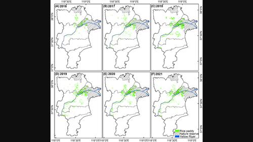
Large river deltas are usually ecologically important wetland habitats, but also fertile agricultural exploitation areas, creating a conflict of long‐running substantial interest between agricultural expansion and wetland conservation. Over the past several years, large‐scale cultivation of water‐consuming rice has been growing rapidly in the semi‐arid climate of the Yellow River Delta (YRD). Timely monitoring of rice cultivation dynamics is of great significance for sustainable ecological conservation of the delta, which has insufficient freshwater resources. This study proposed a stratified metrics‐based method that integrates statistical spectral indices and phenological metrics at different growing stages to improve the accuracy of rice paddy classification in areas where rice and wetlands coexist. We applied the method to time‐series Sentinel‐1/2 images to produce annual rice paddy maps of the YRD from 2016 to 2021. Together with rice paddy data from 2011 to 2015 from Statistical Yearbooks of Dongying Bureau of Statistics, we investigated the expansion dynamics over the past decade and in this paper discuss the advantages and disadvantages of rice cultivation expansion over wetland ecosystem conservation. Rapid expansion of rice cultivation intensifies water conflicts, and adversely affects wetland restoration in the YRD. Considering the important ecological services of rice paddies as alternative habitats, we argue for maintaining a reasonable scale of rice paddies and optimizing their distribution as a potential solution to achieving the overall sustainable conservation of the YRD in the context of water scarcity.
求助全文
通过发布文献求助,成功后即可免费获取论文全文。 去求助
来源期刊
Remote Sensing in Ecology and Conservation
Remote Sensing in Ecology and Conservation Earth and Planetary Sciences-Computers in Earth Sciences
CiteScore
9.80
自引率
5.50%
发文量
69
审稿时长
18 weeks
期刊介绍: emote Sensing in Ecology and Conservation provides a forum for rapid, peer-reviewed publication of novel, multidisciplinary research at the interface between remote sensing science and ecology and conservation. The journal prioritizes findings that advance the scientific basis of ecology and conservation, promoting the development of remote-sensing based methods relevant to the management of land use and biological systems at all levels, from populations and species to ecosystems and biomes. The journal defines remote sensing in its broadest sense, including data acquisition by hand-held and fixed ground-based sensors, such as camera traps and acoustic recorders, and sensors on airplanes and satellites. The intended journal’s audience includes ecologists, conservation scientists, policy makers, managers of terrestrial and aquatic systems, remote sensing scientists, and students. Remote Sensing in Ecology and Conservation is a fully open access journal from Wiley and the Zoological Society of London. Remote sensing has enormous potential as to provide information on the state of, and pressures on, biological diversity and ecosystem services, at multiple spatial and temporal scales. This new publication provides a forum for multidisciplinary research in remote sensing science, ecological research and conservation science.
×
引用
GB/T 7714-2015
复制
MLA
复制
APA
复制
导出至
BibTeX EndNote RefMan NoteFirst NoteExpress
×
提示
您的信息不完整,为了账户安全,请先补充。
现在去补充
×
提示
您因"违规操作"
具体请查看互助需知
我知道了
×
提示
确定
请完成安全验证×
copy
已复制链接
快去分享给好友吧!
我知道了
右上角分享
点击右上角分享
0
联系我们:info@booksci.cn Book学术提供免费学术资源搜索服务,方便国内外学者检索中英文文献。致力于提供最便捷和优质的服务体验。 Copyright © 2023 布克学术 All rights reserved.
京ICP备2023020795号-1
ghs 京公网安备 11010802042870号
Book学术文献互助
Book学术文献互助群
群 号:481959085
Book学术官方微信