将遥感影像与PROSAIL‐D和XGBoost方法相结合绘制红树林叶面积指数(LAI)

IF 3.9 2区 环境科学与生态学 Q1 ECOLOGY
Demei Zhao, Jianing Zhen, Yinghui Zhang, Jing Miao, Z. Shen, Xiapeng Jiang, Junjie Wang, Jincheng Jiang, Yuzhi Tang, Guofeng Wu
{"title":"将遥感影像与PROSAIL‐D和XGBoost方法相结合绘制红树林叶面积指数(LAI)","authors":"Demei Zhao, Jianing Zhen, Yinghui Zhang, Jing Miao, Z. Shen, Xiapeng Jiang, Junjie Wang, Jincheng Jiang, Yuzhi Tang, Guofeng Wu","doi":"10.1002/rse2.315","DOIUrl":null,"url":null,"abstract":"Leaf area index (LAI) is a vital parameter reflecting vegetation structure, physio‐ecological process and growth development. Accurate estimation of mangrove LAI is fundamental for assessing the ecological restoration and sustainable development of mangrove ecosystems. To date, very few studies have explored the hybrid method of radiative transfer model (RTM) and machine‐learning model in retrieving mangrove LAI with different satellite sensors. This study investigated the capabilities of combining the PROSAIL‐D model, XGBoost (extreme gradient boosting) and remote sensing images in estimating mangrove LAI, considering the spatial resolutions and spectral vegetation indices (VIs) of Landsat‐8, Sentinel‐2, Worldview‐2 and Zhuhai‐1 images, and further explored the role of eco‐environmental factors in the spatial distribution of LAI in Gaoqiao Mangrove Reserve, China. The results showed that the Zhuhai‐1 acquires the best estimation accuracy ( RVal2 (the determination coefficient of validation) = 0.86, RPD (residual prediction deviation) = 3.36 and RMSE (root mean square error) = 0.31), followed by Worldview‐2 ( RVal2 = 0.84, RPD = 2.64 and RMSE = 0.33), Sentinel‐2 ( RVal2 = 0.34, RPD = 1.33 and RMSE = 0.62) and Landsat‐8 ( RVal2 = 0.29, RPD = 1.03 and RMSE = 0.71). The newly developed three‐band VIs ( B443−B864/B443+B864−2×B561 with Landsat‐8, B490−B842/B490+B842−2×B705 with Sentinel‐2, B427−B832/B908−B832 with Worldview‐2 and B896−B700/B776−B700 with Zhuhai‐1) were efficient estimators of mangrove LAI. Moreover, elevation and species composition could greatly affect the spatial distribution of mangrove LAI. We concluded that the hybrid method of PROSAIL‐D and XGBoost model using VIs derived from Zhuhai‐1 hyperspectral image could be deemed as basic method and input variables of mapping mangrove LAI, and could be effectively and widely applied in generating mangrove LAI products at the regional and national scales.","PeriodicalId":21132,"journal":{"name":"Remote Sensing in Ecology and Conservation","volume":" ","pages":""},"PeriodicalIF":3.9000,"publicationDate":"2022-10-25","publicationTypes":"Journal Article","fieldsOfStudy":null,"isOpenAccess":false,"openAccessPdf":"","citationCount":"6","resultStr":"{\"title\":\"Mapping mangrove leaf area index (LAI) by combining remote sensing images with PROSAIL‐D and XGBoost methods\",\"authors\":\"Demei Zhao, Jianing Zhen, Yinghui Zhang, Jing Miao, Z. Shen, Xiapeng Jiang, Junjie Wang, Jincheng Jiang, Yuzhi Tang, Guofeng Wu\",\"doi\":\"10.1002/rse2.315\",\"DOIUrl\":null,\"url\":null,\"abstract\":\"Leaf area index (LAI) is a vital parameter reflecting vegetation structure, physio‐ecological process and growth development. Accurate estimation of mangrove LAI is fundamental for assessing the ecological restoration and sustainable development of mangrove ecosystems. To date, very few studies have explored the hybrid method of radiative transfer model (RTM) and machine‐learning model in retrieving mangrove LAI with different satellite sensors. This study investigated the capabilities of combining the PROSAIL‐D model, XGBoost (extreme gradient boosting) and remote sensing images in estimating mangrove LAI, considering the spatial resolutions and spectral vegetation indices (VIs) of Landsat‐8, Sentinel‐2, Worldview‐2 and Zhuhai‐1 images, and further explored the role of eco‐environmental factors in the spatial distribution of LAI in Gaoqiao Mangrove Reserve, China. The results showed that the Zhuhai‐1 acquires the best estimation accuracy ( RVal2 (the determination coefficient of validation) = 0.86, RPD (residual prediction deviation) = 3.36 and RMSE (root mean square error) = 0.31), followed by Worldview‐2 ( RVal2 = 0.84, RPD = 2.64 and RMSE = 0.33), Sentinel‐2 ( RVal2 = 0.34, RPD = 1.33 and RMSE = 0.62) and Landsat‐8 ( RVal2 = 0.29, RPD = 1.03 and RMSE = 0.71). The newly developed three‐band VIs ( B443−B864/B443+B864−2×B561 with Landsat‐8, B490−B842/B490+B842−2×B705 with Sentinel‐2, B427−B832/B908−B832 with Worldview‐2 and B896−B700/B776−B700 with Zhuhai‐1) were efficient estimators of mangrove LAI. Moreover, elevation and species composition could greatly affect the spatial distribution of mangrove LAI. We concluded that the hybrid method of PROSAIL‐D and XGBoost model using VIs derived from Zhuhai‐1 hyperspectral image could be deemed as basic method and input variables of mapping mangrove LAI, and could be effectively and widely applied in generating mangrove LAI products at the regional and national scales.\",\"PeriodicalId\":21132,\"journal\":{\"name\":\"Remote Sensing in Ecology and Conservation\",\"volume\":\" \",\"pages\":\"\"},\"PeriodicalIF\":3.9000,\"publicationDate\":\"2022-10-25\",\"publicationTypes\":\"Journal Article\",\"fieldsOfStudy\":null,\"isOpenAccess\":false,\"openAccessPdf\":\"\",\"citationCount\":\"6\",\"resultStr\":null,\"platform\":\"Semanticscholar\",\"paperid\":null,\"PeriodicalName\":\"Remote Sensing in Ecology and Conservation\",\"FirstCategoryId\":\"93\",\"ListUrlMain\":\"https://doi.org/10.1002/rse2.315\",\"RegionNum\":2,\"RegionCategory\":\"环境科学与生态学\",\"ArticlePicture\":[],\"TitleCN\":null,\"AbstractTextCN\":null,\"PMCID\":null,\"EPubDate\":\"\",\"PubModel\":\"\",\"JCR\":\"Q1\",\"JCRName\":\"ECOLOGY\",\"Score\":null,\"Total\":0}","platform":"Semanticscholar","paperid":null,"PeriodicalName":"Remote Sensing in Ecology and Conservation","FirstCategoryId":"93","ListUrlMain":"https://doi.org/10.1002/rse2.315","RegionNum":2,"RegionCategory":"环境科学与生态学","ArticlePicture":[],"TitleCN":null,"AbstractTextCN":null,"PMCID":null,"EPubDate":"","PubModel":"","JCR":"Q1","JCRName":"ECOLOGY","Score":null,"Total":0}
引用次数: 6

摘要

叶面积指数是反映植被结构、生理生态过程和生长发育的重要参数。准确估计红树林LAI是评估红树林生态系统生态恢复和可持续发展的基础。到目前为止,很少有研究探索辐射传输模型(RTM)和机器学习模型的混合方法来检索不同卫星传感器的红树林LAI。本研究考察了结合PROSAIL‐D模型、XGBoost(极端梯度增强)和遥感图像估计红树林LAI的能力,同时考虑了Landsat‐8、Sentinel‐2、Worldview‐2和珠海‐1图像的空间分辨率和光谱植被指数,进一步探讨了生态环境因子在高桥红树林保护区LAI空间分布中的作用。结果表明,珠海-1获得了最佳的估计精度(RVal2(验证的确定系数)=0.86,RPD(残差预测偏差)=3.36和RMSE(均方根误差)=0.31),其次是世界观-2(RVal2=0.84,RPD=2.64和RMSE=0.33),Sentinel‐2(RVal2=0.34,RPD=1.33,RMSE=0.62)和Landsat‐8(RVal0=0.29,RPD=1.03,RMSE=0.71)。新开发的三波段VI(B443−B864/B443+B864−2×B561与Landsat‑8,B490−B842/B490+B842−2×B705与Sentinel‑2,B427−B832/B908−B832与Worldview‐2,B896−B700/B776−B700与珠海‐1)是红树林LAI的有效估计量。此外,海拔和物种组成对红树林LAI的空间分布有很大影响。我们得出的结论是,PROSAIL‐D和XGBoost模型的混合方法使用珠海-1高光谱图像中的VIs,可以作为绘制红树林LAI的基本方法和输入变量,可以在区域和国家尺度上有效而广泛地应用于生成红树林LAI产品。
本文章由计算机程序翻译,如有差异,请以英文原文为准。

Mapping mangrove leaf area index (LAI) by combining remote sensing images with PROSAIL‐D and XGBoost methods

Mapping mangrove leaf area index (LAI) by combining remote sensing images with PROSAIL‐D and XGBoost methods
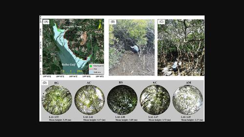
Leaf area index (LAI) is a vital parameter reflecting vegetation structure, physio‐ecological process and growth development. Accurate estimation of mangrove LAI is fundamental for assessing the ecological restoration and sustainable development of mangrove ecosystems. To date, very few studies have explored the hybrid method of radiative transfer model (RTM) and machine‐learning model in retrieving mangrove LAI with different satellite sensors. This study investigated the capabilities of combining the PROSAIL‐D model, XGBoost (extreme gradient boosting) and remote sensing images in estimating mangrove LAI, considering the spatial resolutions and spectral vegetation indices (VIs) of Landsat‐8, Sentinel‐2, Worldview‐2 and Zhuhai‐1 images, and further explored the role of eco‐environmental factors in the spatial distribution of LAI in Gaoqiao Mangrove Reserve, China. The results showed that the Zhuhai‐1 acquires the best estimation accuracy ( RVal2 (the determination coefficient of validation) = 0.86, RPD (residual prediction deviation) = 3.36 and RMSE (root mean square error) = 0.31), followed by Worldview‐2 ( RVal2 = 0.84, RPD = 2.64 and RMSE = 0.33), Sentinel‐2 ( RVal2 = 0.34, RPD = 1.33 and RMSE = 0.62) and Landsat‐8 ( RVal2 = 0.29, RPD = 1.03 and RMSE = 0.71). The newly developed three‐band VIs ( B443−B864/B443+B864−2×B561 with Landsat‐8, B490−B842/B490+B842−2×B705 with Sentinel‐2, B427−B832/B908−B832 with Worldview‐2 and B896−B700/B776−B700 with Zhuhai‐1) were efficient estimators of mangrove LAI. Moreover, elevation and species composition could greatly affect the spatial distribution of mangrove LAI. We concluded that the hybrid method of PROSAIL‐D and XGBoost model using VIs derived from Zhuhai‐1 hyperspectral image could be deemed as basic method and input variables of mapping mangrove LAI, and could be effectively and widely applied in generating mangrove LAI products at the regional and national scales.
求助全文
通过发布文献求助,成功后即可免费获取论文全文。 去求助
来源期刊
Remote Sensing in Ecology and Conservation
Remote Sensing in Ecology and Conservation Earth and Planetary Sciences-Computers in Earth Sciences
CiteScore
9.80
自引率
5.50%
发文量
69
审稿时长
18 weeks
期刊介绍: emote Sensing in Ecology and Conservation provides a forum for rapid, peer-reviewed publication of novel, multidisciplinary research at the interface between remote sensing science and ecology and conservation. The journal prioritizes findings that advance the scientific basis of ecology and conservation, promoting the development of remote-sensing based methods relevant to the management of land use and biological systems at all levels, from populations and species to ecosystems and biomes. The journal defines remote sensing in its broadest sense, including data acquisition by hand-held and fixed ground-based sensors, such as camera traps and acoustic recorders, and sensors on airplanes and satellites. The intended journal’s audience includes ecologists, conservation scientists, policy makers, managers of terrestrial and aquatic systems, remote sensing scientists, and students. Remote Sensing in Ecology and Conservation is a fully open access journal from Wiley and the Zoological Society of London. Remote sensing has enormous potential as to provide information on the state of, and pressures on, biological diversity and ecosystem services, at multiple spatial and temporal scales. This new publication provides a forum for multidisciplinary research in remote sensing science, ecological research and conservation science.
×
引用
GB/T 7714-2015
复制
MLA
复制
APA
复制
导出至
BibTeX EndNote RefMan NoteFirst NoteExpress
×
提示
您的信息不完整,为了账户安全,请先补充。
现在去补充
×
提示
您因"违规操作"
具体请查看互助需知
我知道了
×
提示
确定
请完成安全验证×
copy
已复制链接
快去分享给好友吧!
我知道了
右上角分享
点击右上角分享
0
联系我们:info@booksci.cn Book学术提供免费学术资源搜索服务,方便国内外学者检索中英文文献。致力于提供最便捷和优质的服务体验。 Copyright © 2023 布克学术 All rights reserved.
京ICP备2023020795号-1
ghs 京公网安备 11010802042870号
Book学术文献互助
Book学术文献互助群
群 号:481959085
Book学术官方微信