Xungang Shi, Cheng Hu, J. Soderholm, J. Chapman, Huafeng Mao, Kai Cui, Zhijun Ma, Dongli Wu, R. Fuller
{"title":"利用气象雷达监测东亚-澳大拉西亚候鸟迁徙的前景","authors":"Xungang Shi, Cheng Hu, J. Soderholm, J. Chapman, Huafeng Mao, Kai Cui, Zhijun Ma, Dongli Wu, R. Fuller","doi":"10.1002/rse2.307","DOIUrl":null,"url":null,"abstract":"Each year, billions of birds migrate across the globe, and interpretation of weather radar signals is increasingly being used to document the spatial and temporal migration patterns in Europe and America. Such approaches are yet to be applied in the East Asian‐Australasian Flyway (EAAF), one of the most species‐rich and threatened flyways in the world. Logistical challenges limit direct on‐ground monitoring of migratory birds in many parts of the EAAF, resulting in knowledge gaps on population status and site use that limit evidence‐based conservation planning. Weather radar data have great potential for achieving comprehensive migratory bird monitoring along the EAAF. In this study, we discuss the feasibility and challenges of using weather radar to complement on‐ground bird migration surveys in the flyway. We summarize the location, capacity and data availability of weather radars across EAAF countries, as well as the spatial coverage of the radars with respect to migrants' geographic distribution and migration hotspots along the flyway, with an exemplar analysis of biological movement patterns extracted from Chinese weather radars. There are more than 430 weather radars in EAAF countries, covering on average half of bird species' passage and non‐breeding distributions, as well as 70% of internationally important sites for migratory shorebirds. We conclude that the weather radar network could be a powerful resource for monitoring bird movements over the full annual cycle throughout much of the EAAF, providing estimates of migration traffic rates, site use, and long‐term population trends, especially in remote and less‐surveyed regions. Analyses of weather radar data would complement existing ornithological surveys and help understand the past and present status of the avian community in a highly threatened flyway.","PeriodicalId":21132,"journal":{"name":"Remote Sensing in Ecology and Conservation","volume":" ","pages":""},"PeriodicalIF":3.9000,"publicationDate":"2022-10-27","publicationTypes":"Journal Article","fieldsOfStudy":null,"isOpenAccess":false,"openAccessPdf":"","citationCount":"0","resultStr":"{\"title\":\"Prospects for monitoring bird migration along the East Asian‐Australasian Flyway using weather radar\",\"authors\":\"Xungang Shi, Cheng Hu, J. Soderholm, J. Chapman, Huafeng Mao, Kai Cui, Zhijun Ma, Dongli Wu, R. Fuller\",\"doi\":\"10.1002/rse2.307\",\"DOIUrl\":null,\"url\":null,\"abstract\":\"Each year, billions of birds migrate across the globe, and interpretation of weather radar signals is increasingly being used to document the spatial and temporal migration patterns in Europe and America. Such approaches are yet to be applied in the East Asian‐Australasian Flyway (EAAF), one of the most species‐rich and threatened flyways in the world. Logistical challenges limit direct on‐ground monitoring of migratory birds in many parts of the EAAF, resulting in knowledge gaps on population status and site use that limit evidence‐based conservation planning. Weather radar data have great potential for achieving comprehensive migratory bird monitoring along the EAAF. In this study, we discuss the feasibility and challenges of using weather radar to complement on‐ground bird migration surveys in the flyway. We summarize the location, capacity and data availability of weather radars across EAAF countries, as well as the spatial coverage of the radars with respect to migrants' geographic distribution and migration hotspots along the flyway, with an exemplar analysis of biological movement patterns extracted from Chinese weather radars. There are more than 430 weather radars in EAAF countries, covering on average half of bird species' passage and non‐breeding distributions, as well as 70% of internationally important sites for migratory shorebirds. We conclude that the weather radar network could be a powerful resource for monitoring bird movements over the full annual cycle throughout much of the EAAF, providing estimates of migration traffic rates, site use, and long‐term population trends, especially in remote and less‐surveyed regions. Analyses of weather radar data would complement existing ornithological surveys and help understand the past and present status of the avian community in a highly threatened flyway.\",\"PeriodicalId\":21132,\"journal\":{\"name\":\"Remote Sensing in Ecology and Conservation\",\"volume\":\" \",\"pages\":\"\"},\"PeriodicalIF\":3.9000,\"publicationDate\":\"2022-10-27\",\"publicationTypes\":\"Journal Article\",\"fieldsOfStudy\":null,\"isOpenAccess\":false,\"openAccessPdf\":\"\",\"citationCount\":\"0\",\"resultStr\":null,\"platform\":\"Semanticscholar\",\"paperid\":null,\"PeriodicalName\":\"Remote Sensing in Ecology and Conservation\",\"FirstCategoryId\":\"93\",\"ListUrlMain\":\"https://doi.org/10.1002/rse2.307\",\"RegionNum\":2,\"RegionCategory\":\"环境科学与生态学\",\"ArticlePicture\":[],\"TitleCN\":null,\"AbstractTextCN\":null,\"PMCID\":null,\"EPubDate\":\"\",\"PubModel\":\"\",\"JCR\":\"Q1\",\"JCRName\":\"ECOLOGY\",\"Score\":null,\"Total\":0}","platform":"Semanticscholar","paperid":null,"PeriodicalName":"Remote Sensing in Ecology and Conservation","FirstCategoryId":"93","ListUrlMain":"https://doi.org/10.1002/rse2.307","RegionNum":2,"RegionCategory":"环境科学与生态学","ArticlePicture":[],"TitleCN":null,"AbstractTextCN":null,"PMCID":null,"EPubDate":"","PubModel":"","JCR":"Q1","JCRName":"ECOLOGY","Score":null,"Total":0}
Prospects for monitoring bird migration along the East Asian‐Australasian Flyway using weather radar
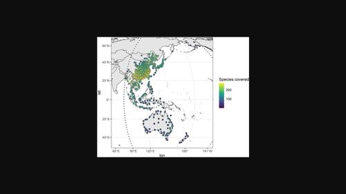
Each year, billions of birds migrate across the globe, and interpretation of weather radar signals is increasingly being used to document the spatial and temporal migration patterns in Europe and America. Such approaches are yet to be applied in the East Asian‐Australasian Flyway (EAAF), one of the most species‐rich and threatened flyways in the world. Logistical challenges limit direct on‐ground monitoring of migratory birds in many parts of the EAAF, resulting in knowledge gaps on population status and site use that limit evidence‐based conservation planning. Weather radar data have great potential for achieving comprehensive migratory bird monitoring along the EAAF. In this study, we discuss the feasibility and challenges of using weather radar to complement on‐ground bird migration surveys in the flyway. We summarize the location, capacity and data availability of weather radars across EAAF countries, as well as the spatial coverage of the radars with respect to migrants' geographic distribution and migration hotspots along the flyway, with an exemplar analysis of biological movement patterns extracted from Chinese weather radars. There are more than 430 weather radars in EAAF countries, covering on average half of bird species' passage and non‐breeding distributions, as well as 70% of internationally important sites for migratory shorebirds. We conclude that the weather radar network could be a powerful resource for monitoring bird movements over the full annual cycle throughout much of the EAAF, providing estimates of migration traffic rates, site use, and long‐term population trends, especially in remote and less‐surveyed regions. Analyses of weather radar data would complement existing ornithological surveys and help understand the past and present status of the avian community in a highly threatened flyway.
期刊介绍:
emote Sensing in Ecology and Conservation provides a forum for rapid, peer-reviewed publication of novel, multidisciplinary research at the interface between remote sensing science and ecology and conservation. The journal prioritizes findings that advance the scientific basis of ecology and conservation, promoting the development of remote-sensing based methods relevant to the management of land use and biological systems at all levels, from populations and species to ecosystems and biomes. The journal defines remote sensing in its broadest sense, including data acquisition by hand-held and fixed ground-based sensors, such as camera traps and acoustic recorders, and sensors on airplanes and satellites. The intended journal’s audience includes ecologists, conservation scientists, policy makers, managers of terrestrial and aquatic systems, remote sensing scientists, and students.
Remote Sensing in Ecology and Conservation is a fully open access journal from Wiley and the Zoological Society of London. Remote sensing has enormous potential as to provide information on the state of, and pressures on, biological diversity and ecosystem services, at multiple spatial and temporal scales. This new publication provides a forum for multidisciplinary research in remote sensing science, ecological research and conservation science.