Na Chen, N. Tsendbazar, Daniela Requena Suarez, J. Verbesselt, M. Herold
{"title":"利用多源遥感数据表征巴西再生森林的地上生物量和树木覆盖","authors":"Na Chen, N. Tsendbazar, Daniela Requena Suarez, J. Verbesselt, M. Herold","doi":"10.1002/rse2.328","DOIUrl":null,"url":null,"abstract":"Characterization of regrowing forests is vital for understanding forest dynamics to assess the impacts on carbon stocks and to support sustainable forest management. Although remote sensing is a key tool for understanding and monitoring forest dynamics, the use of exclusively remotely sensed data to explore the effects of different variables on regrowing forests across all biomes in Brazil has rarely been investigated. Here, we analyzed how environmental and human factors affect regrowing forests. Based on Brazil's secondary forest age map, 3060 locations disturbed between 1984 and 2018 were sampled, interpreted and analyzed in different biomes. We interpreted the time since disturbance for the sampled pixels in Google Earth Engine. Elevation, slope, climatic water deficit (CWD), the total Nitrogen of soil, cation exchange capacity (CEC) of soil, surrounding tree cover, distance to roads, distance to settlements and fire frequency were analyzed in their importance for predicting aboveground biomass (AGB) and tree cover derived from global forest aboveground biomass map and tree cover map, respectively. Results show that time since disturbance interpreted from satellite time series is the most important predictor for characterizing AGB and tree cover of regrowing forests. AGB increased with increasing time since disturbance, surrounding tree cover, soil total N, slope, distance to roads, distance to settlements and decreased with larger fire frequency, CWD and CEC of soil. Tree cover increased with larger time since disturbance, soil total N, surrounding tree cover, distance to roads, distance to settlements, slope and decreased with increasing elevation and CWD. These results emphasize the importance of remotely sensing products as key opportunities to improve the characterization of forest regrowth and to reduce data gaps and uncertainties related to forest carbon sink estimation. Our results provide a better understanding of regional forest dynamics, toward developing and assessing effective forest‐related restoration and climatic mitigation strategies.","PeriodicalId":21132,"journal":{"name":"Remote Sensing in Ecology and Conservation","volume":" ","pages":""},"PeriodicalIF":3.9000,"publicationDate":"2023-04-27","publicationTypes":"Journal Article","fieldsOfStudy":null,"isOpenAccess":false,"openAccessPdf":"","citationCount":"1","resultStr":"{\"title\":\"Characterizing aboveground biomass and tree cover of regrowing forests in Brazil using multi‐source remote sensing data\",\"authors\":\"Na Chen, N. Tsendbazar, Daniela Requena Suarez, J. Verbesselt, M. Herold\",\"doi\":\"10.1002/rse2.328\",\"DOIUrl\":null,\"url\":null,\"abstract\":\"Characterization of regrowing forests is vital for understanding forest dynamics to assess the impacts on carbon stocks and to support sustainable forest management. Although remote sensing is a key tool for understanding and monitoring forest dynamics, the use of exclusively remotely sensed data to explore the effects of different variables on regrowing forests across all biomes in Brazil has rarely been investigated. Here, we analyzed how environmental and human factors affect regrowing forests. Based on Brazil's secondary forest age map, 3060 locations disturbed between 1984 and 2018 were sampled, interpreted and analyzed in different biomes. We interpreted the time since disturbance for the sampled pixels in Google Earth Engine. Elevation, slope, climatic water deficit (CWD), the total Nitrogen of soil, cation exchange capacity (CEC) of soil, surrounding tree cover, distance to roads, distance to settlements and fire frequency were analyzed in their importance for predicting aboveground biomass (AGB) and tree cover derived from global forest aboveground biomass map and tree cover map, respectively. Results show that time since disturbance interpreted from satellite time series is the most important predictor for characterizing AGB and tree cover of regrowing forests. AGB increased with increasing time since disturbance, surrounding tree cover, soil total N, slope, distance to roads, distance to settlements and decreased with larger fire frequency, CWD and CEC of soil. Tree cover increased with larger time since disturbance, soil total N, surrounding tree cover, distance to roads, distance to settlements, slope and decreased with increasing elevation and CWD. These results emphasize the importance of remotely sensing products as key opportunities to improve the characterization of forest regrowth and to reduce data gaps and uncertainties related to forest carbon sink estimation. Our results provide a better understanding of regional forest dynamics, toward developing and assessing effective forest‐related restoration and climatic mitigation strategies.\",\"PeriodicalId\":21132,\"journal\":{\"name\":\"Remote Sensing in Ecology and Conservation\",\"volume\":\" \",\"pages\":\"\"},\"PeriodicalIF\":3.9000,\"publicationDate\":\"2023-04-27\",\"publicationTypes\":\"Journal Article\",\"fieldsOfStudy\":null,\"isOpenAccess\":false,\"openAccessPdf\":\"\",\"citationCount\":\"1\",\"resultStr\":null,\"platform\":\"Semanticscholar\",\"paperid\":null,\"PeriodicalName\":\"Remote Sensing in Ecology and Conservation\",\"FirstCategoryId\":\"93\",\"ListUrlMain\":\"https://doi.org/10.1002/rse2.328\",\"RegionNum\":2,\"RegionCategory\":\"环境科学与生态学\",\"ArticlePicture\":[],\"TitleCN\":null,\"AbstractTextCN\":null,\"PMCID\":null,\"EPubDate\":\"\",\"PubModel\":\"\",\"JCR\":\"Q1\",\"JCRName\":\"ECOLOGY\",\"Score\":null,\"Total\":0}","platform":"Semanticscholar","paperid":null,"PeriodicalName":"Remote Sensing in Ecology and Conservation","FirstCategoryId":"93","ListUrlMain":"https://doi.org/10.1002/rse2.328","RegionNum":2,"RegionCategory":"环境科学与生态学","ArticlePicture":[],"TitleCN":null,"AbstractTextCN":null,"PMCID":null,"EPubDate":"","PubModel":"","JCR":"Q1","JCRName":"ECOLOGY","Score":null,"Total":0}
Characterizing aboveground biomass and tree cover of regrowing forests in Brazil using multi‐source remote sensing data
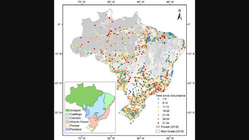
Characterization of regrowing forests is vital for understanding forest dynamics to assess the impacts on carbon stocks and to support sustainable forest management. Although remote sensing is a key tool for understanding and monitoring forest dynamics, the use of exclusively remotely sensed data to explore the effects of different variables on regrowing forests across all biomes in Brazil has rarely been investigated. Here, we analyzed how environmental and human factors affect regrowing forests. Based on Brazil's secondary forest age map, 3060 locations disturbed between 1984 and 2018 were sampled, interpreted and analyzed in different biomes. We interpreted the time since disturbance for the sampled pixels in Google Earth Engine. Elevation, slope, climatic water deficit (CWD), the total Nitrogen of soil, cation exchange capacity (CEC) of soil, surrounding tree cover, distance to roads, distance to settlements and fire frequency were analyzed in their importance for predicting aboveground biomass (AGB) and tree cover derived from global forest aboveground biomass map and tree cover map, respectively. Results show that time since disturbance interpreted from satellite time series is the most important predictor for characterizing AGB and tree cover of regrowing forests. AGB increased with increasing time since disturbance, surrounding tree cover, soil total N, slope, distance to roads, distance to settlements and decreased with larger fire frequency, CWD and CEC of soil. Tree cover increased with larger time since disturbance, soil total N, surrounding tree cover, distance to roads, distance to settlements, slope and decreased with increasing elevation and CWD. These results emphasize the importance of remotely sensing products as key opportunities to improve the characterization of forest regrowth and to reduce data gaps and uncertainties related to forest carbon sink estimation. Our results provide a better understanding of regional forest dynamics, toward developing and assessing effective forest‐related restoration and climatic mitigation strategies.
期刊介绍:
emote Sensing in Ecology and Conservation provides a forum for rapid, peer-reviewed publication of novel, multidisciplinary research at the interface between remote sensing science and ecology and conservation. The journal prioritizes findings that advance the scientific basis of ecology and conservation, promoting the development of remote-sensing based methods relevant to the management of land use and biological systems at all levels, from populations and species to ecosystems and biomes. The journal defines remote sensing in its broadest sense, including data acquisition by hand-held and fixed ground-based sensors, such as camera traps and acoustic recorders, and sensors on airplanes and satellites. The intended journal’s audience includes ecologists, conservation scientists, policy makers, managers of terrestrial and aquatic systems, remote sensing scientists, and students.
Remote Sensing in Ecology and Conservation is a fully open access journal from Wiley and the Zoological Society of London. Remote sensing has enormous potential as to provide information on the state of, and pressures on, biological diversity and ecosystem services, at multiple spatial and temporal scales. This new publication provides a forum for multidisciplinary research in remote sensing science, ecological research and conservation science.