Elizabeth D. Keller, Timothy W. Hilton, Adrian Benson, Sapthala Karalliyadda, Shanju Xie, Kevin R. Gurney, Jocelyn C. Turnbull
{"title":"Mahuika‐Auckland:新西兰奥克兰地区化石燃料CO2排放的时空解析数据产品","authors":"Elizabeth D. Keller, Timothy W. Hilton, Adrian Benson, Sapthala Karalliyadda, Shanju Xie, Kevin R. Gurney, Jocelyn C. Turnbull","doi":"10.1002/gdj3.181","DOIUrl":null,"url":null,"abstract":"<p>Accurate, high-resolution and sector-specific greenhouse gas emissions information is increasingly needed for the development of local, targeted mitigation policies. We describe a detailed, spatially and temporally resolved CO<sub>2</sub> emissions data product, Mahuika-Auckland, for Auckland, New Zealand, based on Auckland's regional greenhouse gas and air emissions inventories. Emissions are provided at 500 m spatial resolution and at a 1-hr time step, a level of detail not previously available for any New Zealand city. We divide fossil fuel emissions into six sectors that comprise the majority of Auckland Region's CO<sub>2</sub> emissions profile: on-road transport, industrial non-point buildings and point sources, commercial non-point buildings, residential non-point buildings, air transport and sea transport. We also include separate layers representing biogenic CO<sub>2</sub> emissions (primarily waste and wood burning), as these are significant sources in Auckland. We distribute emissions spatially and temporally based on activity data, energy and fuel consumption patterns, and population statistics. The code to generate Mahuika-Auckland has been designed to be flexible so that updated information and/or data from more recent years can easily be incorporated. This data product improves upon New Zealand's current inventories that are only resolved at the regional and annual scale, providing a new level of detail that can be used as a prior estimate for atmospheric inversions, to inform emissions reduction policies and to guide the development of zero carbon pathways.</p>","PeriodicalId":54351,"journal":{"name":"Geoscience Data Journal","volume":"10 3","pages":"347-367"},"PeriodicalIF":2.4000,"publicationDate":"2022-10-14","publicationTypes":"Journal Article","fieldsOfStudy":null,"isOpenAccess":false,"openAccessPdf":"https://onlinelibrary.wiley.com/doi/epdf/10.1002/gdj3.181","citationCount":"1","resultStr":"{\"title\":\"Mahuika-Auckland: A spatially and temporally resolved fossil fuel CO2 emissions data product for Auckland, New Zealand\",\"authors\":\"Elizabeth D. Keller, Timothy W. Hilton, Adrian Benson, Sapthala Karalliyadda, Shanju Xie, Kevin R. Gurney, Jocelyn C. Turnbull\",\"doi\":\"10.1002/gdj3.181\",\"DOIUrl\":null,\"url\":null,\"abstract\":\"<p>Accurate, high-resolution and sector-specific greenhouse gas emissions information is increasingly needed for the development of local, targeted mitigation policies. We describe a detailed, spatially and temporally resolved CO<sub>2</sub> emissions data product, Mahuika-Auckland, for Auckland, New Zealand, based on Auckland's regional greenhouse gas and air emissions inventories. Emissions are provided at 500 m spatial resolution and at a 1-hr time step, a level of detail not previously available for any New Zealand city. We divide fossil fuel emissions into six sectors that comprise the majority of Auckland Region's CO<sub>2</sub> emissions profile: on-road transport, industrial non-point buildings and point sources, commercial non-point buildings, residential non-point buildings, air transport and sea transport. We also include separate layers representing biogenic CO<sub>2</sub> emissions (primarily waste and wood burning), as these are significant sources in Auckland. We distribute emissions spatially and temporally based on activity data, energy and fuel consumption patterns, and population statistics. The code to generate Mahuika-Auckland has been designed to be flexible so that updated information and/or data from more recent years can easily be incorporated. This data product improves upon New Zealand's current inventories that are only resolved at the regional and annual scale, providing a new level of detail that can be used as a prior estimate for atmospheric inversions, to inform emissions reduction policies and to guide the development of zero carbon pathways.</p>\",\"PeriodicalId\":54351,\"journal\":{\"name\":\"Geoscience Data Journal\",\"volume\":\"10 3\",\"pages\":\"347-367\"},\"PeriodicalIF\":2.4000,\"publicationDate\":\"2022-10-14\",\"publicationTypes\":\"Journal Article\",\"fieldsOfStudy\":null,\"isOpenAccess\":false,\"openAccessPdf\":\"https://onlinelibrary.wiley.com/doi/epdf/10.1002/gdj3.181\",\"citationCount\":\"1\",\"resultStr\":null,\"platform\":\"Semanticscholar\",\"paperid\":null,\"PeriodicalName\":\"Geoscience Data Journal\",\"FirstCategoryId\":\"89\",\"ListUrlMain\":\"https://onlinelibrary.wiley.com/doi/10.1002/gdj3.181\",\"RegionNum\":3,\"RegionCategory\":\"地球科学\",\"ArticlePicture\":[],\"TitleCN\":null,\"AbstractTextCN\":null,\"PMCID\":null,\"EPubDate\":\"\",\"PubModel\":\"\",\"JCR\":\"Q2\",\"JCRName\":\"GEOSCIENCES, MULTIDISCIPLINARY\",\"Score\":null,\"Total\":0}","platform":"Semanticscholar","paperid":null,"PeriodicalName":"Geoscience Data Journal","FirstCategoryId":"89","ListUrlMain":"https://onlinelibrary.wiley.com/doi/10.1002/gdj3.181","RegionNum":3,"RegionCategory":"地球科学","ArticlePicture":[],"TitleCN":null,"AbstractTextCN":null,"PMCID":null,"EPubDate":"","PubModel":"","JCR":"Q2","JCRName":"GEOSCIENCES, MULTIDISCIPLINARY","Score":null,"Total":0}
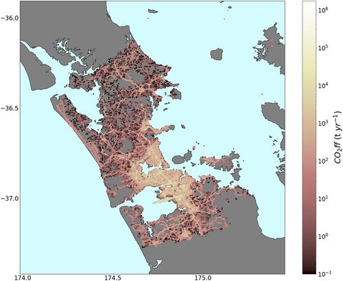
Mahuika-Auckland: A spatially and temporally resolved fossil fuel CO2 emissions data product for Auckland, New Zealand
Accurate, high-resolution and sector-specific greenhouse gas emissions information is increasingly needed for the development of local, targeted mitigation policies. We describe a detailed, spatially and temporally resolved CO2 emissions data product, Mahuika-Auckland, for Auckland, New Zealand, based on Auckland's regional greenhouse gas and air emissions inventories. Emissions are provided at 500 m spatial resolution and at a 1-hr time step, a level of detail not previously available for any New Zealand city. We divide fossil fuel emissions into six sectors that comprise the majority of Auckland Region's CO2 emissions profile: on-road transport, industrial non-point buildings and point sources, commercial non-point buildings, residential non-point buildings, air transport and sea transport. We also include separate layers representing biogenic CO2 emissions (primarily waste and wood burning), as these are significant sources in Auckland. We distribute emissions spatially and temporally based on activity data, energy and fuel consumption patterns, and population statistics. The code to generate Mahuika-Auckland has been designed to be flexible so that updated information and/or data from more recent years can easily be incorporated. This data product improves upon New Zealand's current inventories that are only resolved at the regional and annual scale, providing a new level of detail that can be used as a prior estimate for atmospheric inversions, to inform emissions reduction policies and to guide the development of zero carbon pathways.
Geoscience Data JournalGEOSCIENCES, MULTIDISCIPLINARYMETEOROLOGY-METEOROLOGY & ATMOSPHERIC SCIENCES
CiteScore
5.90
自引率
9.40%
发文量
35
审稿时长
4 weeks
期刊介绍:
Geoscience Data Journal provides an Open Access platform where scientific data can be formally published, in a way that includes scientific peer-review. Thus the dataset creator attains full credit for their efforts, while also improving the scientific record, providing version control for the community and allowing major datasets to be fully described, cited and discovered.
An online-only journal, GDJ publishes short data papers cross-linked to – and citing – datasets that have been deposited in approved data centres and awarded DOIs. The journal will also accept articles on data services, and articles which support and inform data publishing best practices.
Data is at the heart of science and scientific endeavour. The curation of data and the science associated with it is as important as ever in our understanding of the changing earth system and thereby enabling us to make future predictions. Geoscience Data Journal is working with recognised Data Centres across the globe to develop the future strategy for data publication, the recognition of the value of data and the communication and exploitation of data to the wider science and stakeholder communities.

 求助内容:
求助内容: 应助结果提醒方式:


