Zijian Cheng, Huiru Cui, Daqing Wang, Haoli Xu, Yi Wang, Zhao Lu, Xiaoning Zhao, Yue Shi, Xiaoying Lian, Guolin Tao
{"title":"基于长时间序列遥感数据的澎湖列岛地下水潜力填图","authors":"Zijian Cheng, Huiru Cui, Daqing Wang, Haoli Xu, Yi Wang, Zhao Lu, Xiaoning Zhao, Yue Shi, Xiaoying Lian, Guolin Tao","doi":"10.1002/gdj3.173","DOIUrl":null,"url":null,"abstract":"<p>Islands are special bodies of land surrounded by seawater. Many islands are facing water shortages as the demand for groundwater increases, thus, highlighting the importance and urgency of the assessment, planning, and management of island groundwater resources. To facilitate the same, the groundwater potential of the Penghu Islands in China was assessed for the first time using remote sensing (RS), geographic information system (GIS), and the analytic hierarchy process (AHP). Long-term series remote sensing studies were also conducted to monitor the dynamic change in groundwater potential and to identify groundwater potential areas. In this study, the geological environment factors were normalized, and their weight was allocated based on the AHP of RS and GIS. The groundwater potential assessment (GPA) index, established using the weighted comprehensive algorithm, was used to analyse groundwater potential and demarcate groundwater potential zones. Finally, the trend in the spatio-temporal variation of groundwater potential was analysed using long-term series remote sensing data. The results from 2015 to 2021 showed that the Penghu Islands can be divided into five groundwater potential zones of different grades, such as 6.3%–8.1% of grade I, 22.2%–24.2% of grade II, 23%–24.4% of grade III, 19.6%–21% of grade IV, and 25.1%–25.5% of grade V. The results of the GPA were verified by comparing them with the abundance of water-content rock formation in hydrogeologic maps, which yielded correlation coefficients of 78.3%–88.9%. Overall, the groundwater potential zones of different grades in the study area tended to be stable all year-round, including the zones of grades I and II. The results of this study highlighted the reliability of predicting groundwater potential based on long-term series remote sensing data and its usability to local personnel in appropriate groundwater resource planning and management.</p>","PeriodicalId":54351,"journal":{"name":"Geoscience Data Journal","volume":"10 4","pages":"471-484"},"PeriodicalIF":3.3000,"publicationDate":"2022-09-25","publicationTypes":"Journal Article","fieldsOfStudy":null,"isOpenAccess":false,"openAccessPdf":"https://onlinelibrary.wiley.com/doi/epdf/10.1002/gdj3.173","citationCount":"1","resultStr":"{\"title\":\"Groundwater potential mapping based on long time series remote sensing data in Penghu Islands, China\",\"authors\":\"Zijian Cheng, Huiru Cui, Daqing Wang, Haoli Xu, Yi Wang, Zhao Lu, Xiaoning Zhao, Yue Shi, Xiaoying Lian, Guolin Tao\",\"doi\":\"10.1002/gdj3.173\",\"DOIUrl\":null,\"url\":null,\"abstract\":\"<p>Islands are special bodies of land surrounded by seawater. Many islands are facing water shortages as the demand for groundwater increases, thus, highlighting the importance and urgency of the assessment, planning, and management of island groundwater resources. To facilitate the same, the groundwater potential of the Penghu Islands in China was assessed for the first time using remote sensing (RS), geographic information system (GIS), and the analytic hierarchy process (AHP). Long-term series remote sensing studies were also conducted to monitor the dynamic change in groundwater potential and to identify groundwater potential areas. In this study, the geological environment factors were normalized, and their weight was allocated based on the AHP of RS and GIS. The groundwater potential assessment (GPA) index, established using the weighted comprehensive algorithm, was used to analyse groundwater potential and demarcate groundwater potential zones. Finally, the trend in the spatio-temporal variation of groundwater potential was analysed using long-term series remote sensing data. The results from 2015 to 2021 showed that the Penghu Islands can be divided into five groundwater potential zones of different grades, such as 6.3%–8.1% of grade I, 22.2%–24.2% of grade II, 23%–24.4% of grade III, 19.6%–21% of grade IV, and 25.1%–25.5% of grade V. The results of the GPA were verified by comparing them with the abundance of water-content rock formation in hydrogeologic maps, which yielded correlation coefficients of 78.3%–88.9%. Overall, the groundwater potential zones of different grades in the study area tended to be stable all year-round, including the zones of grades I and II. The results of this study highlighted the reliability of predicting groundwater potential based on long-term series remote sensing data and its usability to local personnel in appropriate groundwater resource planning and management.</p>\",\"PeriodicalId\":54351,\"journal\":{\"name\":\"Geoscience Data Journal\",\"volume\":\"10 4\",\"pages\":\"471-484\"},\"PeriodicalIF\":3.3000,\"publicationDate\":\"2022-09-25\",\"publicationTypes\":\"Journal Article\",\"fieldsOfStudy\":null,\"isOpenAccess\":false,\"openAccessPdf\":\"https://onlinelibrary.wiley.com/doi/epdf/10.1002/gdj3.173\",\"citationCount\":\"1\",\"resultStr\":null,\"platform\":\"Semanticscholar\",\"paperid\":null,\"PeriodicalName\":\"Geoscience Data Journal\",\"FirstCategoryId\":\"89\",\"ListUrlMain\":\"https://onlinelibrary.wiley.com/doi/10.1002/gdj3.173\",\"RegionNum\":3,\"RegionCategory\":\"地球科学\",\"ArticlePicture\":[],\"TitleCN\":null,\"AbstractTextCN\":null,\"PMCID\":null,\"EPubDate\":\"\",\"PubModel\":\"\",\"JCR\":\"Q2\",\"JCRName\":\"GEOSCIENCES, MULTIDISCIPLINARY\",\"Score\":null,\"Total\":0}","platform":"Semanticscholar","paperid":null,"PeriodicalName":"Geoscience Data Journal","FirstCategoryId":"89","ListUrlMain":"https://onlinelibrary.wiley.com/doi/10.1002/gdj3.173","RegionNum":3,"RegionCategory":"地球科学","ArticlePicture":[],"TitleCN":null,"AbstractTextCN":null,"PMCID":null,"EPubDate":"","PubModel":"","JCR":"Q2","JCRName":"GEOSCIENCES, MULTIDISCIPLINARY","Score":null,"Total":0}
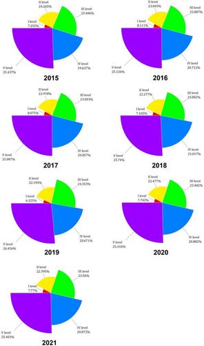
Groundwater potential mapping based on long time series remote sensing data in Penghu Islands, China
Islands are special bodies of land surrounded by seawater. Many islands are facing water shortages as the demand for groundwater increases, thus, highlighting the importance and urgency of the assessment, planning, and management of island groundwater resources. To facilitate the same, the groundwater potential of the Penghu Islands in China was assessed for the first time using remote sensing (RS), geographic information system (GIS), and the analytic hierarchy process (AHP). Long-term series remote sensing studies were also conducted to monitor the dynamic change in groundwater potential and to identify groundwater potential areas. In this study, the geological environment factors were normalized, and their weight was allocated based on the AHP of RS and GIS. The groundwater potential assessment (GPA) index, established using the weighted comprehensive algorithm, was used to analyse groundwater potential and demarcate groundwater potential zones. Finally, the trend in the spatio-temporal variation of groundwater potential was analysed using long-term series remote sensing data. The results from 2015 to 2021 showed that the Penghu Islands can be divided into five groundwater potential zones of different grades, such as 6.3%–8.1% of grade I, 22.2%–24.2% of grade II, 23%–24.4% of grade III, 19.6%–21% of grade IV, and 25.1%–25.5% of grade V. The results of the GPA were verified by comparing them with the abundance of water-content rock formation in hydrogeologic maps, which yielded correlation coefficients of 78.3%–88.9%. Overall, the groundwater potential zones of different grades in the study area tended to be stable all year-round, including the zones of grades I and II. The results of this study highlighted the reliability of predicting groundwater potential based on long-term series remote sensing data and its usability to local personnel in appropriate groundwater resource planning and management.
Geoscience Data JournalGEOSCIENCES, MULTIDISCIPLINARYMETEOROLOGY-METEOROLOGY & ATMOSPHERIC SCIENCES
CiteScore
5.90
自引率
9.40%
发文量
35
审稿时长
4 weeks
期刊介绍:
Geoscience Data Journal provides an Open Access platform where scientific data can be formally published, in a way that includes scientific peer-review. Thus the dataset creator attains full credit for their efforts, while also improving the scientific record, providing version control for the community and allowing major datasets to be fully described, cited and discovered.
An online-only journal, GDJ publishes short data papers cross-linked to – and citing – datasets that have been deposited in approved data centres and awarded DOIs. The journal will also accept articles on data services, and articles which support and inform data publishing best practices.
Data is at the heart of science and scientific endeavour. The curation of data and the science associated with it is as important as ever in our understanding of the changing earth system and thereby enabling us to make future predictions. Geoscience Data Journal is working with recognised Data Centres across the globe to develop the future strategy for data publication, the recognition of the value of data and the communication and exploitation of data to the wider science and stakeholder communities.

 求助内容:
求助内容: 应助结果提醒方式:


