Bagrey Mm Ngwira, Phillimon Tambala, A Maria Perez, Cameron Bowie, David H Molyneux
{"title":"马拉维淋巴丝虫病感染的地理分布。","authors":"Bagrey Mm Ngwira, Phillimon Tambala, A Maria Perez, Cameron Bowie, David H Molyneux","doi":"10.1186/1475-2883-6-12","DOIUrl":null,"url":null,"abstract":"<p><p>Mapping distribution of lymphatic filariasis (LF) is a prerequisite for planning national elimination programmes. Results from a nation wide mapping survey for lymphatic filariasis (LF) in Malawi are presented. Thirty-five villages were sampled from 23 districts excluding three districts (Karonga, Chikwawa and Nsanje) that had already been mapped and Likoma, an Island, where access was not possible in the time frame of the survey. Antigenaemia prevalence [based on immunochromatographic card tests (ICT)] ranged from 0% to 35.9%. Villages from the western side of the country and distant from the lake tended to be of lower prevalence. The exception was a village in Mchinji district on the Malawi-Zambia border where a prevalence of 18.2% was found. In contrast villages from lake shore districts [Salima, Mangochi, Balaka and Ntcheu (Bwanje valley)] and Phalombe had prevalences of over 20%.A national map is developed which incorporates data from surveys in Karonga, Chikwawa and Nsanje districts, carried out in 2000. There is a marked decline in prevalence with increasing altitude. Further analysis revealed a strong negative correlation (R2 = 0.7 p < 0.001) between altitude and prevalence. These results suggest that the lake shore, Phalombe plain and the lower Shire valley will be priority areas for the Malawi LF elimination programme. Implications of these findings as regards implementing a national LF elimination programme in Malawi are discussed.</p>","PeriodicalId":84756,"journal":{"name":"Filaria journal","volume":" ","pages":"12"},"PeriodicalIF":0.0000,"publicationDate":"2007-11-29","publicationTypes":"Journal Article","fieldsOfStudy":null,"isOpenAccess":false,"openAccessPdf":"https://sci-hub-pdf.com/10.1186/1475-2883-6-12","citationCount":"39","resultStr":"{\"title\":\"The geographical distribution of lymphatic filariasis infection in Malawi.\",\"authors\":\"Bagrey Mm Ngwira, Phillimon Tambala, A Maria Perez, Cameron Bowie, David H Molyneux\",\"doi\":\"10.1186/1475-2883-6-12\",\"DOIUrl\":null,\"url\":null,\"abstract\":\"<p><p>Mapping distribution of lymphatic filariasis (LF) is a prerequisite for planning national elimination programmes. Results from a nation wide mapping survey for lymphatic filariasis (LF) in Malawi are presented. Thirty-five villages were sampled from 23 districts excluding three districts (Karonga, Chikwawa and Nsanje) that had already been mapped and Likoma, an Island, where access was not possible in the time frame of the survey. Antigenaemia prevalence [based on immunochromatographic card tests (ICT)] ranged from 0% to 35.9%. Villages from the western side of the country and distant from the lake tended to be of lower prevalence. The exception was a village in Mchinji district on the Malawi-Zambia border where a prevalence of 18.2% was found. In contrast villages from lake shore districts [Salima, Mangochi, Balaka and Ntcheu (Bwanje valley)] and Phalombe had prevalences of over 20%.A national map is developed which incorporates data from surveys in Karonga, Chikwawa and Nsanje districts, carried out in 2000. There is a marked decline in prevalence with increasing altitude. Further analysis revealed a strong negative correlation (R2 = 0.7 p < 0.001) between altitude and prevalence. These results suggest that the lake shore, Phalombe plain and the lower Shire valley will be priority areas for the Malawi LF elimination programme. Implications of these findings as regards implementing a national LF elimination programme in Malawi are discussed.</p>\",\"PeriodicalId\":84756,\"journal\":{\"name\":\"Filaria journal\",\"volume\":\" \",\"pages\":\"12\"},\"PeriodicalIF\":0.0000,\"publicationDate\":\"2007-11-29\",\"publicationTypes\":\"Journal Article\",\"fieldsOfStudy\":null,\"isOpenAccess\":false,\"openAccessPdf\":\"https://sci-hub-pdf.com/10.1186/1475-2883-6-12\",\"citationCount\":\"39\",\"resultStr\":null,\"platform\":\"Semanticscholar\",\"paperid\":null,\"PeriodicalName\":\"Filaria journal\",\"FirstCategoryId\":\"1085\",\"ListUrlMain\":\"https://doi.org/10.1186/1475-2883-6-12\",\"RegionNum\":0,\"RegionCategory\":null,\"ArticlePicture\":[],\"TitleCN\":null,\"AbstractTextCN\":null,\"PMCID\":null,\"EPubDate\":\"\",\"PubModel\":\"\",\"JCR\":\"\",\"JCRName\":\"\",\"Score\":null,\"Total\":0}","platform":"Semanticscholar","paperid":null,"PeriodicalName":"Filaria journal","FirstCategoryId":"1085","ListUrlMain":"https://doi.org/10.1186/1475-2883-6-12","RegionNum":0,"RegionCategory":null,"ArticlePicture":[],"TitleCN":null,"AbstractTextCN":null,"PMCID":null,"EPubDate":"","PubModel":"","JCR":"","JCRName":"","Score":null,"Total":0}
引用次数: 39
摘要
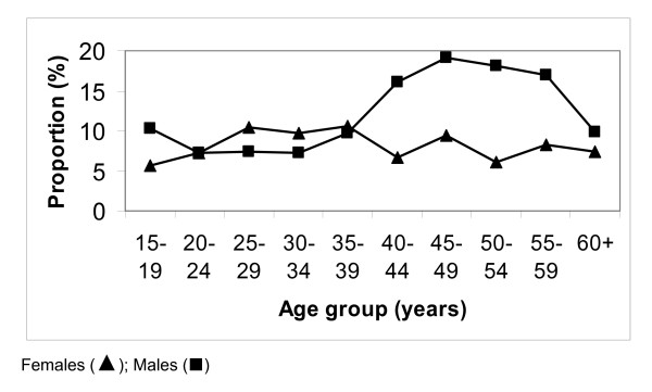
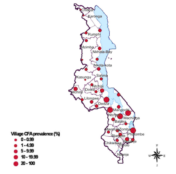
绘制淋巴丝虫病分布地图是规划国家消灭规划的先决条件。结果从全国范围内的地图调查淋巴丝虫病(LF)在马拉维提出。从23个县抽取了35个村庄,其中不包括已经绘制地图的3个县(卡隆加、奇克瓦瓦和恩桑杰)和在调查期间无法进入的利科马岛。抗原血症的患病率[基于免疫层析卡试验(ICT)]从0%到35.9%不等。在该国西部和远离湖泊的村庄,患病率往往较低。唯一的例外是马拉维-赞比亚边境Mchinji区的一个村庄,患病率为18.2%。相比之下,湖岸地区[Salima、Mangochi、Balaka和Ntcheu (Bwanje山谷)]和Phalombe的村庄患病率超过20%。编制了一份全国地图,其中包括2000年在Karonga、Chikwawa和Nsanje地区进行的调查数据。随着海拔的升高,患病率明显下降。进一步分析发现海拔高度与患病率呈显著负相关(R2 = 0.7 p < 0.001)。这些结果表明,湖岸、Phalombe平原和较低的Shire河谷将是马拉维消灭LF规划的优先地区。讨论了这些调查结果对在马拉维执行一项全国消灭LF方案的影响。
The geographical distribution of lymphatic filariasis infection in Malawi.
Mapping distribution of lymphatic filariasis (LF) is a prerequisite for planning national elimination programmes. Results from a nation wide mapping survey for lymphatic filariasis (LF) in Malawi are presented. Thirty-five villages were sampled from 23 districts excluding three districts (Karonga, Chikwawa and Nsanje) that had already been mapped and Likoma, an Island, where access was not possible in the time frame of the survey. Antigenaemia prevalence [based on immunochromatographic card tests (ICT)] ranged from 0% to 35.9%. Villages from the western side of the country and distant from the lake tended to be of lower prevalence. The exception was a village in Mchinji district on the Malawi-Zambia border where a prevalence of 18.2% was found. In contrast villages from lake shore districts [Salima, Mangochi, Balaka and Ntcheu (Bwanje valley)] and Phalombe had prevalences of over 20%.A national map is developed which incorporates data from surveys in Karonga, Chikwawa and Nsanje districts, carried out in 2000. There is a marked decline in prevalence with increasing altitude. Further analysis revealed a strong negative correlation (R2 = 0.7 p < 0.001) between altitude and prevalence. These results suggest that the lake shore, Phalombe plain and the lower Shire valley will be priority areas for the Malawi LF elimination programme. Implications of these findings as regards implementing a national LF elimination programme in Malawi are discussed.

 求助内容:
求助内容: 应助结果提醒方式:


