Shanmugavelu Sabesan, Hari Kishan K Raju, AdiNarayanan Srividya, Pradeep Kumar Das
{"title":"划定淋巴丝虫病传播危险区:地理环境方法。","authors":"Shanmugavelu Sabesan, Hari Kishan K Raju, AdiNarayanan Srividya, Pradeep Kumar Das","doi":"10.1186/1475-2883-5-12","DOIUrl":null,"url":null,"abstract":"<p><strong>Background: </strong>The Global Programme to Eliminate Lymphatic Filariasis (GPELF) depends upon Mass Drug Administration (MDA) to interrupt transmission. Therefore, delimitation of transmission risk areas is an important step, and hence we attempted to define a geo-environmental risk model (GERM) for determining the areas of potential transmission of lymphatic filariasis.</p><p><strong>Methods: </strong>A range of geo-environmental variables has been selected, and customized on GIS platform to develop GERM for identifying the areas of filariasis transmission in terms of \"risk\" and \"non-risk\". The model was validated through a 'ground truth study' following standard procedure using GIS tools for sampling and Immuno-chromotographic Test (ICT) for screening the individuals.</p><p><strong>Results: </strong>A map for filariasis transmission was created and stratified into different spatial entities, \"risk' and \"non-risk\", depending on Filariasis Transmission Risk Index (FTRI). The model estimation corroborated well with the ground (observed) data.</p><p><strong>Conclusion: </strong>The geo-environmental risk model developed on GIS platform is useful for spatial delimitation purpose on a macro scale.</p>","PeriodicalId":84756,"journal":{"name":"Filaria journal","volume":"5 ","pages":"12"},"PeriodicalIF":0.0000,"publicationDate":"2006-11-09","publicationTypes":"Journal Article","fieldsOfStudy":null,"isOpenAccess":false,"openAccessPdf":"https://sci-hub-pdf.com/10.1186/1475-2883-5-12","citationCount":"39","resultStr":"{\"title\":\"Delimitation of lymphatic filariasis transmission risk areas: a geo-environmental approach.\",\"authors\":\"Shanmugavelu Sabesan, Hari Kishan K Raju, AdiNarayanan Srividya, Pradeep Kumar Das\",\"doi\":\"10.1186/1475-2883-5-12\",\"DOIUrl\":null,\"url\":null,\"abstract\":\"<p><strong>Background: </strong>The Global Programme to Eliminate Lymphatic Filariasis (GPELF) depends upon Mass Drug Administration (MDA) to interrupt transmission. Therefore, delimitation of transmission risk areas is an important step, and hence we attempted to define a geo-environmental risk model (GERM) for determining the areas of potential transmission of lymphatic filariasis.</p><p><strong>Methods: </strong>A range of geo-environmental variables has been selected, and customized on GIS platform to develop GERM for identifying the areas of filariasis transmission in terms of \\\"risk\\\" and \\\"non-risk\\\". The model was validated through a 'ground truth study' following standard procedure using GIS tools for sampling and Immuno-chromotographic Test (ICT) for screening the individuals.</p><p><strong>Results: </strong>A map for filariasis transmission was created and stratified into different spatial entities, \\\"risk' and \\\"non-risk\\\", depending on Filariasis Transmission Risk Index (FTRI). The model estimation corroborated well with the ground (observed) data.</p><p><strong>Conclusion: </strong>The geo-environmental risk model developed on GIS platform is useful for spatial delimitation purpose on a macro scale.</p>\",\"PeriodicalId\":84756,\"journal\":{\"name\":\"Filaria journal\",\"volume\":\"5 \",\"pages\":\"12\"},\"PeriodicalIF\":0.0000,\"publicationDate\":\"2006-11-09\",\"publicationTypes\":\"Journal Article\",\"fieldsOfStudy\":null,\"isOpenAccess\":false,\"openAccessPdf\":\"https://sci-hub-pdf.com/10.1186/1475-2883-5-12\",\"citationCount\":\"39\",\"resultStr\":null,\"platform\":\"Semanticscholar\",\"paperid\":null,\"PeriodicalName\":\"Filaria journal\",\"FirstCategoryId\":\"1085\",\"ListUrlMain\":\"https://doi.org/10.1186/1475-2883-5-12\",\"RegionNum\":0,\"RegionCategory\":null,\"ArticlePicture\":[],\"TitleCN\":null,\"AbstractTextCN\":null,\"PMCID\":null,\"EPubDate\":\"\",\"PubModel\":\"\",\"JCR\":\"\",\"JCRName\":\"\",\"Score\":null,\"Total\":0}","platform":"Semanticscholar","paperid":null,"PeriodicalName":"Filaria journal","FirstCategoryId":"1085","ListUrlMain":"https://doi.org/10.1186/1475-2883-5-12","RegionNum":0,"RegionCategory":null,"ArticlePicture":[],"TitleCN":null,"AbstractTextCN":null,"PMCID":null,"EPubDate":"","PubModel":"","JCR":"","JCRName":"","Score":null,"Total":0}
Delimitation of lymphatic filariasis transmission risk areas: a geo-environmental approach.
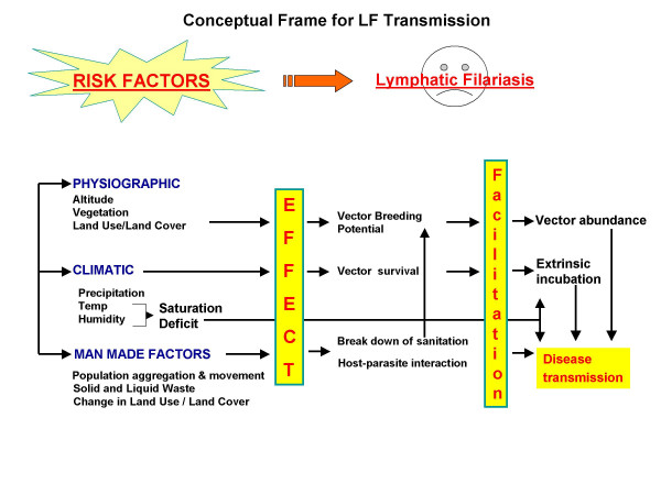
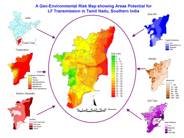
Background: The Global Programme to Eliminate Lymphatic Filariasis (GPELF) depends upon Mass Drug Administration (MDA) to interrupt transmission. Therefore, delimitation of transmission risk areas is an important step, and hence we attempted to define a geo-environmental risk model (GERM) for determining the areas of potential transmission of lymphatic filariasis.
Methods: A range of geo-environmental variables has been selected, and customized on GIS platform to develop GERM for identifying the areas of filariasis transmission in terms of "risk" and "non-risk". The model was validated through a 'ground truth study' following standard procedure using GIS tools for sampling and Immuno-chromotographic Test (ICT) for screening the individuals.
Results: A map for filariasis transmission was created and stratified into different spatial entities, "risk' and "non-risk", depending on Filariasis Transmission Risk Index (FTRI). The model estimation corroborated well with the ground (observed) data.
Conclusion: The geo-environmental risk model developed on GIS platform is useful for spatial delimitation purpose on a macro scale.

 求助内容:
求助内容: 应助结果提醒方式:


