{"title":"基于多维关注的海洋溢油遥感监测MOSSM模型。","authors":"Junwei Liao, Zhenpei Li, Xiangwei Tang, Qi Huo, Xing Tong","doi":"10.1007/s10661-025-14676-1","DOIUrl":null,"url":null,"abstract":"<div><p>Marine oil spills pose severe threats to marine ecosystems, where rapid and accurate oil spill region segmentation is crucial for emergency response to disasters. Synthetic Aperture Radar (SAR), with its all-weather and day-night observation capabilities, serves as a vital data source for oil spill monitoring. However, SAR images are susceptible to the interference of speckle noise and complex background, limiting the accuracy of traditional segmentation methods. Therefore, this paper based on DeepLabV3 + proposes an enhanced model—Marine Oil Spill Segmentation Model (MOSSM). Firstly, the SE (Squeeze-and-Excitation) channel attention mechanism is introduced into the Bottleneck structure of ResNet50 to enhance the ability to extract critical features in oil spill regions by dynamically adjusting feature channel weights. Secondly, a High-Low Feature Fusion Module (HLFusion) is designed with spatial, channel, and pixel attention mechanisms incorporated to optimize detail preservation during high-low feature fusion. It effectively mitigates the interference between SAR image noise and background. Experiments based on the SOS oil spill dataset (containing 8,070 SAR images of 256 × 256 pixels) demonstrate that the indexes of MOSSM, including Intersection over Union (IoU) (74.47%), pixel accuracy (91.74%), and recall (85.91%), significantly outperform those of U-Net, FCN, SegNet, and the original DeepLabV3 + . The model particularly excels in segmenting complex oil spill boundaries and scattered oil slicks. This research provides a higher-precision and more robust segmentation method for SAR image oil spill monitoring, offering significant application value for marine environmental disaster warning and emergency decision-making.</p></div>","PeriodicalId":544,"journal":{"name":"Environmental Monitoring and Assessment","volume":"197 11","pages":""},"PeriodicalIF":3.0000,"publicationDate":"2025-10-16","publicationTypes":"Journal Article","fieldsOfStudy":null,"isOpenAccess":false,"openAccessPdf":"","citationCount":"0","resultStr":"{\"title\":\"Multi-dimensional Attention-Based MOSSM Model for Marine Oil Spill Monitoring in SAR image Remote Sensing\",\"authors\":\"Junwei Liao, Zhenpei Li, Xiangwei Tang, Qi Huo, Xing Tong\",\"doi\":\"10.1007/s10661-025-14676-1\",\"DOIUrl\":null,\"url\":null,\"abstract\":\"<div><p>Marine oil spills pose severe threats to marine ecosystems, where rapid and accurate oil spill region segmentation is crucial for emergency response to disasters. Synthetic Aperture Radar (SAR), with its all-weather and day-night observation capabilities, serves as a vital data source for oil spill monitoring. However, SAR images are susceptible to the interference of speckle noise and complex background, limiting the accuracy of traditional segmentation methods. Therefore, this paper based on DeepLabV3 + proposes an enhanced model—Marine Oil Spill Segmentation Model (MOSSM). Firstly, the SE (Squeeze-and-Excitation) channel attention mechanism is introduced into the Bottleneck structure of ResNet50 to enhance the ability to extract critical features in oil spill regions by dynamically adjusting feature channel weights. Secondly, a High-Low Feature Fusion Module (HLFusion) is designed with spatial, channel, and pixel attention mechanisms incorporated to optimize detail preservation during high-low feature fusion. It effectively mitigates the interference between SAR image noise and background. Experiments based on the SOS oil spill dataset (containing 8,070 SAR images of 256 × 256 pixels) demonstrate that the indexes of MOSSM, including Intersection over Union (IoU) (74.47%), pixel accuracy (91.74%), and recall (85.91%), significantly outperform those of U-Net, FCN, SegNet, and the original DeepLabV3 + . The model particularly excels in segmenting complex oil spill boundaries and scattered oil slicks. This research provides a higher-precision and more robust segmentation method for SAR image oil spill monitoring, offering significant application value for marine environmental disaster warning and emergency decision-making.</p></div>\",\"PeriodicalId\":544,\"journal\":{\"name\":\"Environmental Monitoring and Assessment\",\"volume\":\"197 11\",\"pages\":\"\"},\"PeriodicalIF\":3.0000,\"publicationDate\":\"2025-10-16\",\"publicationTypes\":\"Journal Article\",\"fieldsOfStudy\":null,\"isOpenAccess\":false,\"openAccessPdf\":\"\",\"citationCount\":\"0\",\"resultStr\":null,\"platform\":\"Semanticscholar\",\"paperid\":null,\"PeriodicalName\":\"Environmental Monitoring and Assessment\",\"FirstCategoryId\":\"93\",\"ListUrlMain\":\"https://link.springer.com/article/10.1007/s10661-025-14676-1\",\"RegionNum\":4,\"RegionCategory\":\"环境科学与生态学\",\"ArticlePicture\":[],\"TitleCN\":null,\"AbstractTextCN\":null,\"PMCID\":null,\"EPubDate\":\"\",\"PubModel\":\"\",\"JCR\":\"Q3\",\"JCRName\":\"ENVIRONMENTAL SCIENCES\",\"Score\":null,\"Total\":0}","platform":"Semanticscholar","paperid":null,"PeriodicalName":"Environmental Monitoring and Assessment","FirstCategoryId":"93","ListUrlMain":"https://link.springer.com/article/10.1007/s10661-025-14676-1","RegionNum":4,"RegionCategory":"环境科学与生态学","ArticlePicture":[],"TitleCN":null,"AbstractTextCN":null,"PMCID":null,"EPubDate":"","PubModel":"","JCR":"Q3","JCRName":"ENVIRONMENTAL SCIENCES","Score":null,"Total":0}
引用次数: 0
摘要
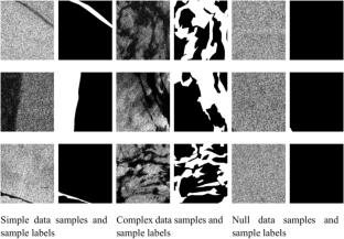
海洋溢油对海洋生态系统构成了严重威胁,快速准确的溢油区域分割是应急处置的关键。合成孔径雷达(SAR)具有全天候和昼夜观测能力,是石油泄漏监测的重要数据源。然而,SAR图像容易受到散斑噪声和复杂背景的干扰,限制了传统分割方法的准确性。因此,本文基于DeepLabV3 +提出了一种增强模型——海洋溢油分割模型(MOSSM)。首先,在ResNet50的瓶颈结构中引入SE (Squeeze-and-Excitation)通道关注机制,通过动态调整特征通道权重,增强对溢油区域关键特征的提取能力;其次,设计了高低特征融合模块(HLFusion),融合空间、通道和像素关注机制,优化高低特征融合过程中的细节保留;有效地减轻了SAR图像噪声与背景的干扰。基于SOS溢油数据集(包含8,070张256 × 256像素的SAR图像)的实验表明,MOSSM的交叉比对(Intersection over Union, IoU)(74.47%)、像素精度(91.74%)和召回率(85.91%)显著优于U-Net、FCN、SegNet和原始DeepLabV3 +。该模型在复杂溢油边界和零散浮油分割方面表现突出。本研究为溢油监测SAR图像提供了精度更高、鲁棒性更强的分割方法,对海洋环境灾害预警和应急决策具有重要的应用价值。
Multi-dimensional Attention-Based MOSSM Model for Marine Oil Spill Monitoring in SAR image Remote Sensing
Marine oil spills pose severe threats to marine ecosystems, where rapid and accurate oil spill region segmentation is crucial for emergency response to disasters. Synthetic Aperture Radar (SAR), with its all-weather and day-night observation capabilities, serves as a vital data source for oil spill monitoring. However, SAR images are susceptible to the interference of speckle noise and complex background, limiting the accuracy of traditional segmentation methods. Therefore, this paper based on DeepLabV3 + proposes an enhanced model—Marine Oil Spill Segmentation Model (MOSSM). Firstly, the SE (Squeeze-and-Excitation) channel attention mechanism is introduced into the Bottleneck structure of ResNet50 to enhance the ability to extract critical features in oil spill regions by dynamically adjusting feature channel weights. Secondly, a High-Low Feature Fusion Module (HLFusion) is designed with spatial, channel, and pixel attention mechanisms incorporated to optimize detail preservation during high-low feature fusion. It effectively mitigates the interference between SAR image noise and background. Experiments based on the SOS oil spill dataset (containing 8,070 SAR images of 256 × 256 pixels) demonstrate that the indexes of MOSSM, including Intersection over Union (IoU) (74.47%), pixel accuracy (91.74%), and recall (85.91%), significantly outperform those of U-Net, FCN, SegNet, and the original DeepLabV3 + . The model particularly excels in segmenting complex oil spill boundaries and scattered oil slicks. This research provides a higher-precision and more robust segmentation method for SAR image oil spill monitoring, offering significant application value for marine environmental disaster warning and emergency decision-making.
期刊介绍:
Environmental Monitoring and Assessment emphasizes technical developments and data arising from environmental monitoring and assessment, the use of scientific principles in the design of monitoring systems at the local, regional and global scales, and the use of monitoring data in assessing the consequences of natural resource management actions and pollution risks to man and the environment.

 求助内容:
求助内容: 应助结果提醒方式:


