Yingge Wang, Rui Shi, Bowen Zhao, Shengbing Yang, Jianxin Yang
{"title":"土地过渡强度谱:一种分析稳定、系统的土地利用和土地覆被变化模式的新方法。","authors":"Yingge Wang, Rui Shi, Bowen Zhao, Shengbing Yang, Jianxin Yang","doi":"10.1007/s10661-025-14672-5","DOIUrl":null,"url":null,"abstract":"<div><p>The acceleration of global environmental change has intensified the pace of land use and land cover change (LULCC) while increasing the uncertainty of its future development. Extracting information from past multi-period land-use transitions and scientifically identifying land-use transition patterns are essential for informing land-use decision-making. To this end, this study proposes a novel transition-level analytical framework—the Land Transition Intensity Spectrum (LTIS). The LTIS integrates absolute and relative transition intensities, gain and loss directions, and multiple temporal intervals. Through a quantitative approach, it identifies transitions that, across multiple periods, stably exhibit targeted tendencies in both absolute magnitude and relative proportion for the initial and final land use and land cover (LULC) classes. These transitions strongly affect the compositional structure of land use and should be prioritized in monitoring and governance. The LTIS was applied to LULC data from seven representative countries between 2000 and 2020, focusing on transitions among six major land classes to evaluate its utility. The results reveal that the LTIS effectively uncovers shared and divergent LULCC patterns across countries. Overall, the LTIS extends the analytical depth of conventional intensity analysis by integrating absolute and relative perspectives while enhancing the visualization and interpretability of land-use transitions.</p></div>","PeriodicalId":544,"journal":{"name":"Environmental Monitoring and Assessment","volume":"197 11","pages":""},"PeriodicalIF":3.0000,"publicationDate":"2025-10-07","publicationTypes":"Journal Article","fieldsOfStudy":null,"isOpenAccess":false,"openAccessPdf":"","citationCount":"0","resultStr":"{\"title\":\"Land transition intensity spectrum: A novel method for analyzing stable and systematic land use and land cover change patterns\",\"authors\":\"Yingge Wang, Rui Shi, Bowen Zhao, Shengbing Yang, Jianxin Yang\",\"doi\":\"10.1007/s10661-025-14672-5\",\"DOIUrl\":null,\"url\":null,\"abstract\":\"<div><p>The acceleration of global environmental change has intensified the pace of land use and land cover change (LULCC) while increasing the uncertainty of its future development. Extracting information from past multi-period land-use transitions and scientifically identifying land-use transition patterns are essential for informing land-use decision-making. To this end, this study proposes a novel transition-level analytical framework—the Land Transition Intensity Spectrum (LTIS). The LTIS integrates absolute and relative transition intensities, gain and loss directions, and multiple temporal intervals. Through a quantitative approach, it identifies transitions that, across multiple periods, stably exhibit targeted tendencies in both absolute magnitude and relative proportion for the initial and final land use and land cover (LULC) classes. These transitions strongly affect the compositional structure of land use and should be prioritized in monitoring and governance. The LTIS was applied to LULC data from seven representative countries between 2000 and 2020, focusing on transitions among six major land classes to evaluate its utility. The results reveal that the LTIS effectively uncovers shared and divergent LULCC patterns across countries. Overall, the LTIS extends the analytical depth of conventional intensity analysis by integrating absolute and relative perspectives while enhancing the visualization and interpretability of land-use transitions.</p></div>\",\"PeriodicalId\":544,\"journal\":{\"name\":\"Environmental Monitoring and Assessment\",\"volume\":\"197 11\",\"pages\":\"\"},\"PeriodicalIF\":3.0000,\"publicationDate\":\"2025-10-07\",\"publicationTypes\":\"Journal Article\",\"fieldsOfStudy\":null,\"isOpenAccess\":false,\"openAccessPdf\":\"\",\"citationCount\":\"0\",\"resultStr\":null,\"platform\":\"Semanticscholar\",\"paperid\":null,\"PeriodicalName\":\"Environmental Monitoring and Assessment\",\"FirstCategoryId\":\"93\",\"ListUrlMain\":\"https://link.springer.com/article/10.1007/s10661-025-14672-5\",\"RegionNum\":4,\"RegionCategory\":\"环境科学与生态学\",\"ArticlePicture\":[],\"TitleCN\":null,\"AbstractTextCN\":null,\"PMCID\":null,\"EPubDate\":\"\",\"PubModel\":\"\",\"JCR\":\"Q3\",\"JCRName\":\"ENVIRONMENTAL SCIENCES\",\"Score\":null,\"Total\":0}","platform":"Semanticscholar","paperid":null,"PeriodicalName":"Environmental Monitoring and Assessment","FirstCategoryId":"93","ListUrlMain":"https://link.springer.com/article/10.1007/s10661-025-14672-5","RegionNum":4,"RegionCategory":"环境科学与生态学","ArticlePicture":[],"TitleCN":null,"AbstractTextCN":null,"PMCID":null,"EPubDate":"","PubModel":"","JCR":"Q3","JCRName":"ENVIRONMENTAL SCIENCES","Score":null,"Total":0}
Land transition intensity spectrum: A novel method for analyzing stable and systematic land use and land cover change patterns
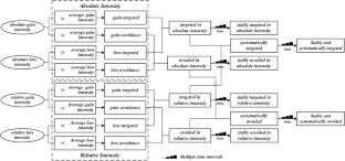
The acceleration of global environmental change has intensified the pace of land use and land cover change (LULCC) while increasing the uncertainty of its future development. Extracting information from past multi-period land-use transitions and scientifically identifying land-use transition patterns are essential for informing land-use decision-making. To this end, this study proposes a novel transition-level analytical framework—the Land Transition Intensity Spectrum (LTIS). The LTIS integrates absolute and relative transition intensities, gain and loss directions, and multiple temporal intervals. Through a quantitative approach, it identifies transitions that, across multiple periods, stably exhibit targeted tendencies in both absolute magnitude and relative proportion for the initial and final land use and land cover (LULC) classes. These transitions strongly affect the compositional structure of land use and should be prioritized in monitoring and governance. The LTIS was applied to LULC data from seven representative countries between 2000 and 2020, focusing on transitions among six major land classes to evaluate its utility. The results reveal that the LTIS effectively uncovers shared and divergent LULCC patterns across countries. Overall, the LTIS extends the analytical depth of conventional intensity analysis by integrating absolute and relative perspectives while enhancing the visualization and interpretability of land-use transitions.
期刊介绍:
Environmental Monitoring and Assessment emphasizes technical developments and data arising from environmental monitoring and assessment, the use of scientific principles in the design of monitoring systems at the local, regional and global scales, and the use of monitoring data in assessing the consequences of natural resource management actions and pollution risks to man and the environment.

 求助内容:
求助内容: 应助结果提醒方式:


