利用WOFOST估算南非数据稀缺的小规模种植系统的实际玉米产量:数据同化方法
IF 8.6
Q1 REMOTE SENSING
International journal of applied earth observation and geoinformation : ITC journal
Pub Date : 2025-09-30
DOI:10.1016/j.jag.2025.104848
引用次数: 0
摘要
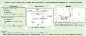
准确的农田一级产量估计对于知情的农业决策和粮食安全至关重要,特别是在数据匮乏的小规模雨养系统中,例如在南非发现的系统。本研究利用基于再校准的数据同化(DA)方法,探讨了将遥感叶面积指数(LAI)整合到WOFOST作物模型中的方法。使用了东开普省两个生长季节(2020-2021年)八个农场的数据。利用2020年两个农场的LAI观测数据,对关键物候参数进行了校准,并引入了影响日总同化的产量缺口因子,并对其与比叶面积进行了优化。优化后的参数在其他农场和季节进行了验证。结果表明,与没有同化的模拟(RMSE = 4817 kg.ha - 1, NRMSE = 112%)相比,DA显著提高了产量预测(RMSE = 472 kg.ha - 1, NRMSE = 11%)。这些发现突出了该方法的潜力,使作物模型适应数据有限的情况,量化产量差距,并支持有效的资源管理。这种方法为同样受到限制的农业系统的决策提供了可扩展的好处。本文章由计算机程序翻译,如有差异,请以英文原文为准。
Estimating actual maize yield with WOFOST in data-scarce small-scale cropping systems of South Africa: Data assimilation approach
Accurate farm-level yield estimation is crucial for informed agricultural decision-making and food security, particularly in data-scarce, small-scale rainfed systems such as those found in South Africa. This study explores the integration of remote sensing-derived leaf area index (LAI) into the WOFOST crop model using a recalibration-based data assimilation (DA) approach. Data from eight farms across two growing seasons (2020–2021) in the Eastern Cape were used. Key phenological parameters were calibrated, and a yield gap factor influencing daily gross assimilation was introduced and optimized alongside the specific leaf area using LAI observations from two farms in 2020. The optimized parameters were validated across additional farms and seasons. Results show that DA significantly improved yield predictions (RMSE = 472 kg.ha−1; NRMSE = 11%) compared to simulations without assimilation (RMSE = 4817 kg.ha−1; NRMSE = 112%). These findings highlight the method’s potential to adapt crop models to data-limited contexts, quantify yield gaps, and support efficient resource management. The approach offers scalable benefits for decision-making in similarly constrained agricultural systems.
求助全文
通过发布文献求助,成功后即可免费获取论文全文。
去求助
来源期刊

International journal of applied earth observation and geoinformation : ITC journal
Global and Planetary Change, Management, Monitoring, Policy and Law, Earth-Surface Processes, Computers in Earth Sciences
CiteScore
12.00
自引率
0.00%
发文量
0
审稿时长
77 days
期刊介绍:
The International Journal of Applied Earth Observation and Geoinformation publishes original papers that utilize earth observation data for natural resource and environmental inventory and management. These data primarily originate from remote sensing platforms, including satellites and aircraft, supplemented by surface and subsurface measurements. Addressing natural resources such as forests, agricultural land, soils, and water, as well as environmental concerns like biodiversity, land degradation, and hazards, the journal explores conceptual and data-driven approaches. It covers geoinformation themes like capturing, databasing, visualization, interpretation, data quality, and spatial uncertainty.
 求助内容:
求助内容: 应助结果提醒方式:


