弥合云的鸿沟:通过CNN特征融合的AHI/ATMS协同全天候海温检索

IF 8.6 Q1 REMOTE SENSING
Donglin Fan , Xin Yang , Hongchang He , Hongjie He , Bolin Fu
{"title":"弥合云的鸿沟:通过CNN特征融合的AHI/ATMS协同全天候海温检索","authors":"Donglin Fan ,&nbsp;Xin Yang ,&nbsp;Hongchang He ,&nbsp;Hongjie He ,&nbsp;Bolin Fu","doi":"10.1016/j.jag.2025.104887","DOIUrl":null,"url":null,"abstract":"<div><div>Infrared-based Sea Surface Temperature (SST) retrieval methods face persistent challenges from cloud-induced data gaps and accuracy degradation. This study bridges this critical limitation through multisensor satellite synergy, integrating geostationary Advanced Himawari Imager (AHI) with Advanced Technology Microwave Sounder (ATMS) data via a Convolutional Neural Network (CNN) for all weather SST retrieval. The CNN model adaptively extracts features from multi-band AHI/ATMS imagery, effectively predicting SST under varying cloud conditions. Evaluation results demonstrate a root mean square error (RMSE) of 2.07 °C, a mean absolute error (MAE) of 1.22 °C, and a coefficient of determination (R<sup>2</sup>) of 0.88 on the test dataset. Under the same CNN framework, unimodal retrievals from AHI and ATMS alone yield substantially lower performance (R<sup>2</sup> = 0.51, RMSE = 3.45 °C; and R<sup>2</sup> = 0.63, RMSE = 2.64 °C, respectively), confirming the complementary benefits of multisensor fusion. Comparisons with a Transformer-based model, the daily OSTIA product, and the official AHI SST product (clear-sky conditions) further indicate that the proposed CNN achieves the highest accuracy. Although RMSE exceeds 1 °C for certain cloud types, the method substantially mitigates cloud-induced data loss and provides a reliable, high-accuracy, all-weather SST retrieval strategy for satellite ocean remote sensing.</div></div>","PeriodicalId":73423,"journal":{"name":"International journal of applied earth observation and geoinformation : ITC journal","volume":"144 ","pages":"Article 104887"},"PeriodicalIF":8.6000,"publicationDate":"2025-10-03","publicationTypes":"Journal Article","fieldsOfStudy":null,"isOpenAccess":false,"openAccessPdf":"","citationCount":"0","resultStr":"{\"title\":\"Bridging the cloud gap: AHI/ATMS synergy through CNN feature fusion for all-weather SST retrieval\",\"authors\":\"Donglin Fan ,&nbsp;Xin Yang ,&nbsp;Hongchang He ,&nbsp;Hongjie He ,&nbsp;Bolin Fu\",\"doi\":\"10.1016/j.jag.2025.104887\",\"DOIUrl\":null,\"url\":null,\"abstract\":\"<div><div>Infrared-based Sea Surface Temperature (SST) retrieval methods face persistent challenges from cloud-induced data gaps and accuracy degradation. This study bridges this critical limitation through multisensor satellite synergy, integrating geostationary Advanced Himawari Imager (AHI) with Advanced Technology Microwave Sounder (ATMS) data via a Convolutional Neural Network (CNN) for all weather SST retrieval. The CNN model adaptively extracts features from multi-band AHI/ATMS imagery, effectively predicting SST under varying cloud conditions. Evaluation results demonstrate a root mean square error (RMSE) of 2.07 °C, a mean absolute error (MAE) of 1.22 °C, and a coefficient of determination (R<sup>2</sup>) of 0.88 on the test dataset. Under the same CNN framework, unimodal retrievals from AHI and ATMS alone yield substantially lower performance (R<sup>2</sup> = 0.51, RMSE = 3.45 °C; and R<sup>2</sup> = 0.63, RMSE = 2.64 °C, respectively), confirming the complementary benefits of multisensor fusion. Comparisons with a Transformer-based model, the daily OSTIA product, and the official AHI SST product (clear-sky conditions) further indicate that the proposed CNN achieves the highest accuracy. Although RMSE exceeds 1 °C for certain cloud types, the method substantially mitigates cloud-induced data loss and provides a reliable, high-accuracy, all-weather SST retrieval strategy for satellite ocean remote sensing.</div></div>\",\"PeriodicalId\":73423,\"journal\":{\"name\":\"International journal of applied earth observation and geoinformation : ITC journal\",\"volume\":\"144 \",\"pages\":\"Article 104887\"},\"PeriodicalIF\":8.6000,\"publicationDate\":\"2025-10-03\",\"publicationTypes\":\"Journal Article\",\"fieldsOfStudy\":null,\"isOpenAccess\":false,\"openAccessPdf\":\"\",\"citationCount\":\"0\",\"resultStr\":null,\"platform\":\"Semanticscholar\",\"paperid\":null,\"PeriodicalName\":\"International journal of applied earth observation and geoinformation : ITC journal\",\"FirstCategoryId\":\"1085\",\"ListUrlMain\":\"https://www.sciencedirect.com/science/article/pii/S1569843225005345\",\"RegionNum\":0,\"RegionCategory\":null,\"ArticlePicture\":[],\"TitleCN\":null,\"AbstractTextCN\":null,\"PMCID\":null,\"EPubDate\":\"\",\"PubModel\":\"\",\"JCR\":\"Q1\",\"JCRName\":\"REMOTE SENSING\",\"Score\":null,\"Total\":0}","platform":"Semanticscholar","paperid":null,"PeriodicalName":"International journal of applied earth observation and geoinformation : ITC journal","FirstCategoryId":"1085","ListUrlMain":"https://www.sciencedirect.com/science/article/pii/S1569843225005345","RegionNum":0,"RegionCategory":null,"ArticlePicture":[],"TitleCN":null,"AbstractTextCN":null,"PMCID":null,"EPubDate":"","PubModel":"","JCR":"Q1","JCRName":"REMOTE SENSING","Score":null,"Total":0}
引用次数: 0

摘要

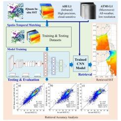
基于红外的海表温度(SST)检索方法面临着云引起的数据缺口和精度下降的持续挑战。本研究通过多传感器卫星协同,通过卷积神经网络(CNN)整合地球同步先进Himawari成像仪(AHI)和先进技术微波测深仪(ATMS)数据,以实现全天候海温检索,从而弥补了这一关键限制。CNN模型自适应提取多波段AHI/ATMS图像的特征,有效预测不同云条件下的海温。评估结果表明,测试数据集的均方根误差(RMSE)为2.07°C,平均绝对误差(MAE)为1.22°C,决定系数(R2)为0.88。在相同的CNN框架下,AHI和ATMS单峰检索的性能明显较低(R2 = 0.51, RMSE = 3.45°C; R2 = 0.63, RMSE = 2.64°C),证实了多传感器融合的互补优势。与基于transformer的模型、每日OSTIA产品和官方AHI SST产品(晴空条件)的比较进一步表明,所提出的CNN达到了最高的精度。虽然某些云类型的RMSE超过1°C,但该方法大大减轻了云引起的数据丢失,并为卫星海洋遥感提供了可靠、高精度、全天候的海温检索策略。
本文章由计算机程序翻译,如有差异,请以英文原文为准。

Bridging the cloud gap: AHI/ATMS synergy through CNN feature fusion for all-weather SST retrieval

Bridging the cloud gap: AHI/ATMS synergy through CNN feature fusion for all-weather SST retrieval
Infrared-based Sea Surface Temperature (SST) retrieval methods face persistent challenges from cloud-induced data gaps and accuracy degradation. This study bridges this critical limitation through multisensor satellite synergy, integrating geostationary Advanced Himawari Imager (AHI) with Advanced Technology Microwave Sounder (ATMS) data via a Convolutional Neural Network (CNN) for all weather SST retrieval. The CNN model adaptively extracts features from multi-band AHI/ATMS imagery, effectively predicting SST under varying cloud conditions. Evaluation results demonstrate a root mean square error (RMSE) of 2.07 °C, a mean absolute error (MAE) of 1.22 °C, and a coefficient of determination (R2) of 0.88 on the test dataset. Under the same CNN framework, unimodal retrievals from AHI and ATMS alone yield substantially lower performance (R2 = 0.51, RMSE = 3.45 °C; and R2 = 0.63, RMSE = 2.64 °C, respectively), confirming the complementary benefits of multisensor fusion. Comparisons with a Transformer-based model, the daily OSTIA product, and the official AHI SST product (clear-sky conditions) further indicate that the proposed CNN achieves the highest accuracy. Although RMSE exceeds 1 °C for certain cloud types, the method substantially mitigates cloud-induced data loss and provides a reliable, high-accuracy, all-weather SST retrieval strategy for satellite ocean remote sensing.
求助全文
通过发布文献求助,成功后即可免费获取论文全文。 去求助
来源期刊
International journal of applied earth observation and geoinformation : ITC journal
International journal of applied earth observation and geoinformation : ITC journal Global and Planetary Change, Management, Monitoring, Policy and Law, Earth-Surface Processes, Computers in Earth Sciences
CiteScore
12.00
自引率
0.00%
发文量
0
审稿时长
77 days
期刊介绍: The International Journal of Applied Earth Observation and Geoinformation publishes original papers that utilize earth observation data for natural resource and environmental inventory and management. These data primarily originate from remote sensing platforms, including satellites and aircraft, supplemented by surface and subsurface measurements. Addressing natural resources such as forests, agricultural land, soils, and water, as well as environmental concerns like biodiversity, land degradation, and hazards, the journal explores conceptual and data-driven approaches. It covers geoinformation themes like capturing, databasing, visualization, interpretation, data quality, and spatial uncertainty.
×
引用
GB/T 7714-2015
复制
MLA
复制
APA
复制
导出至
BibTeX EndNote RefMan NoteFirst NoteExpress
×
提示
您的信息不完整,为了账户安全,请先补充。
现在去补充
×
提示
您因"违规操作"
具体请查看互助需知
我知道了
×
提示
确定
请完成安全验证×
copy
已复制链接
快去分享给好友吧!
我知道了
右上角分享
点击右上角分享
0
联系我们:info@booksci.cn Book学术提供免费学术资源搜索服务,方便国内外学者检索中英文文献。致力于提供最便捷和优质的服务体验。 Copyright © 2023 布克学术 All rights reserved.
京ICP备2023020795号-1
ghs 京公网安备 11010802042870号
Book学术文献互助
Book学术文献互助群
群 号:604180095
Book学术官方微信