利用多源遥感数据和机器学习模型,为厄立特里亚上梅里布地区开发岩石构造图

IF 4.5 Q2 ENVIRONMENTAL SCIENCES
Kabral Mogos Asghede , Abazar M.A. Daoud , Musaab A.A. Mohammed , Woldegabriel Genzebu , Kefela Beyene Kiflay , Péter Pecsmány , János Vágó
{"title":"利用多源遥感数据和机器学习模型,为厄立特里亚上梅里布地区开发岩石构造图","authors":"Kabral Mogos Asghede ,&nbsp;Abazar M.A. Daoud ,&nbsp;Musaab A.A. Mohammed ,&nbsp;Woldegabriel Genzebu ,&nbsp;Kefela Beyene Kiflay ,&nbsp;Péter Pecsmány ,&nbsp;János Vágó","doi":"10.1016/j.rsase.2025.101722","DOIUrl":null,"url":null,"abstract":"<div><div>The Upper Mereb catchment area, located on the Southern zone of Eritrea, is a geologically complex region within the Arabian-Nubian Shield (ANS). The area's intricate litho-structural framework presents significant challenges for mineral exploration and groundwater investigations. Traditional geological mapping techniques often struggle to capture the fine-scale structural details necessary for resource assessments in such complex terrains. This study introduces a novel, high-resolution litho-structural mapping approach, integrating Landsat 9 (L9) multispectral data and gravity data with advanced machine learning algorithms, specifically Artificial Neural Networks (ANN) and Support Vector Machines (SVM). The classification results indicate that ANN outperforms SVM, achieving an accuracy exceeding 79 %, demonstrating the effectiveness of machine learning in distinguishing lithological units. Furthermore, detailed field investigations validate the accuracy of the litho-structural map, showing strong correlations with ground-truth data. A key component of this study is the structural analysis of lineament orientations, which provides critical insights into the tectonic evolution of the region. The Pan-African orogeny has significantly influenced the structural framework, with dominant NE-SW compressional forces creations the fracture patterns. The identified lineaments fall into three primary sets: NW-SE extensional fractures, indicative of crustal stretching; NE-SW release fractures, reflecting zones of stress relaxation; and N-S shear fractures, formed under oblique stress conditions. These structural features highlight the region's complex deformation history and provide essential information for understanding subsurface fluid flow and resource potential. This study represents the first comprehensive application of an integrated remote sensing and geophysical machine learning approach to geological mapping in the Upper Mereb area. The results emphasize the potential of hybrid remote sensing and geophysical data fusion for enhancing structural interpretations, offering a powerful tool for mineral exploration, groundwater assessments, and tectonic studies in the Arabian-Nubian Shield.</div></div>","PeriodicalId":53227,"journal":{"name":"Remote Sensing Applications-Society and Environment","volume":"40 ","pages":"Article 101722"},"PeriodicalIF":4.5000,"publicationDate":"2025-09-12","publicationTypes":"Journal Article","fieldsOfStudy":null,"isOpenAccess":false,"openAccessPdf":"","citationCount":"0","resultStr":"{\"title\":\"Development of a litho-structural map for the Upper Mereb area, Eritrea, using multi-source remote sensing data and machine learning models\",\"authors\":\"Kabral Mogos Asghede ,&nbsp;Abazar M.A. Daoud ,&nbsp;Musaab A.A. Mohammed ,&nbsp;Woldegabriel Genzebu ,&nbsp;Kefela Beyene Kiflay ,&nbsp;Péter Pecsmány ,&nbsp;János Vágó\",\"doi\":\"10.1016/j.rsase.2025.101722\",\"DOIUrl\":null,\"url\":null,\"abstract\":\"<div><div>The Upper Mereb catchment area, located on the Southern zone of Eritrea, is a geologically complex region within the Arabian-Nubian Shield (ANS). The area's intricate litho-structural framework presents significant challenges for mineral exploration and groundwater investigations. Traditional geological mapping techniques often struggle to capture the fine-scale structural details necessary for resource assessments in such complex terrains. This study introduces a novel, high-resolution litho-structural mapping approach, integrating Landsat 9 (L9) multispectral data and gravity data with advanced machine learning algorithms, specifically Artificial Neural Networks (ANN) and Support Vector Machines (SVM). The classification results indicate that ANN outperforms SVM, achieving an accuracy exceeding 79 %, demonstrating the effectiveness of machine learning in distinguishing lithological units. Furthermore, detailed field investigations validate the accuracy of the litho-structural map, showing strong correlations with ground-truth data. A key component of this study is the structural analysis of lineament orientations, which provides critical insights into the tectonic evolution of the region. The Pan-African orogeny has significantly influenced the structural framework, with dominant NE-SW compressional forces creations the fracture patterns. The identified lineaments fall into three primary sets: NW-SE extensional fractures, indicative of crustal stretching; NE-SW release fractures, reflecting zones of stress relaxation; and N-S shear fractures, formed under oblique stress conditions. These structural features highlight the region's complex deformation history and provide essential information for understanding subsurface fluid flow and resource potential. This study represents the first comprehensive application of an integrated remote sensing and geophysical machine learning approach to geological mapping in the Upper Mereb area. The results emphasize the potential of hybrid remote sensing and geophysical data fusion for enhancing structural interpretations, offering a powerful tool for mineral exploration, groundwater assessments, and tectonic studies in the Arabian-Nubian Shield.</div></div>\",\"PeriodicalId\":53227,\"journal\":{\"name\":\"Remote Sensing Applications-Society and Environment\",\"volume\":\"40 \",\"pages\":\"Article 101722\"},\"PeriodicalIF\":4.5000,\"publicationDate\":\"2025-09-12\",\"publicationTypes\":\"Journal Article\",\"fieldsOfStudy\":null,\"isOpenAccess\":false,\"openAccessPdf\":\"\",\"citationCount\":\"0\",\"resultStr\":null,\"platform\":\"Semanticscholar\",\"paperid\":null,\"PeriodicalName\":\"Remote Sensing Applications-Society and Environment\",\"FirstCategoryId\":\"1085\",\"ListUrlMain\":\"https://www.sciencedirect.com/science/article/pii/S2352938525002757\",\"RegionNum\":0,\"RegionCategory\":null,\"ArticlePicture\":[],\"TitleCN\":null,\"AbstractTextCN\":null,\"PMCID\":null,\"EPubDate\":\"\",\"PubModel\":\"\",\"JCR\":\"Q2\",\"JCRName\":\"ENVIRONMENTAL SCIENCES\",\"Score\":null,\"Total\":0}","platform":"Semanticscholar","paperid":null,"PeriodicalName":"Remote Sensing Applications-Society and Environment","FirstCategoryId":"1085","ListUrlMain":"https://www.sciencedirect.com/science/article/pii/S2352938525002757","RegionNum":0,"RegionCategory":null,"ArticlePicture":[],"TitleCN":null,"AbstractTextCN":null,"PMCID":null,"EPubDate":"","PubModel":"","JCR":"Q2","JCRName":"ENVIRONMENTAL SCIENCES","Score":null,"Total":0}
引用次数: 0

摘要

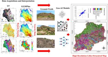
Upper Mereb集水区位于厄立特里亚南部地区,是阿拉伯-努比亚地盾(ANS)内一个地质复杂的地区。该地区复杂的岩石构造框架为矿产勘探和地下水调查带来了重大挑战。传统的地质测绘技术往往难以捕捉到在如此复杂的地形中进行资源评估所必需的精细结构细节。本研究引入了一种新颖的高分辨率岩石-结构制图方法,将Landsat 9 (L9)多光谱数据和重力数据与先进的机器学习算法,特别是人工神经网络(ANN)和支持向量机(SVM)相结合。分类结果表明,人工神经网络优于支持向量机,准确率超过79%,证明了机器学习在区分岩性单元方面的有效性。此外,详细的实地调查验证了岩石构造图的准确性,显示出与地面真实数据的强相关性。本研究的一个关键组成部分是对线向的构造分析,这为该地区的构造演化提供了重要的见解。泛非造山运动对构造格局产生了显著影响,以NE-SW向挤压力为主,形成了断裂格局。已识别的构造面主要分为三组:北西-东西张性断裂,表明地壳伸展;NE-SW释放裂缝,反映应力松弛带;斜应力条件下形成的南北向剪切裂缝。这些构造特征突出了该地区复杂的变形历史,为了解地下流体流动和资源潜力提供了重要信息。该研究首次将遥感和地球物理机器学习方法综合应用于Upper Mereb地区的地质填图。研究结果强调了混合遥感和地球物理数据融合在增强构造解释方面的潜力,为阿拉伯-努比亚地盾的矿产勘探、地下水评估和构造研究提供了强大的工具。
本文章由计算机程序翻译,如有差异,请以英文原文为准。

Development of a litho-structural map for the Upper Mereb area, Eritrea, using multi-source remote sensing data and machine learning models

Development of a litho-structural map for the Upper Mereb area, Eritrea, using multi-source remote sensing data and machine learning models
The Upper Mereb catchment area, located on the Southern zone of Eritrea, is a geologically complex region within the Arabian-Nubian Shield (ANS). The area's intricate litho-structural framework presents significant challenges for mineral exploration and groundwater investigations. Traditional geological mapping techniques often struggle to capture the fine-scale structural details necessary for resource assessments in such complex terrains. This study introduces a novel, high-resolution litho-structural mapping approach, integrating Landsat 9 (L9) multispectral data and gravity data with advanced machine learning algorithms, specifically Artificial Neural Networks (ANN) and Support Vector Machines (SVM). The classification results indicate that ANN outperforms SVM, achieving an accuracy exceeding 79 %, demonstrating the effectiveness of machine learning in distinguishing lithological units. Furthermore, detailed field investigations validate the accuracy of the litho-structural map, showing strong correlations with ground-truth data. A key component of this study is the structural analysis of lineament orientations, which provides critical insights into the tectonic evolution of the region. The Pan-African orogeny has significantly influenced the structural framework, with dominant NE-SW compressional forces creations the fracture patterns. The identified lineaments fall into three primary sets: NW-SE extensional fractures, indicative of crustal stretching; NE-SW release fractures, reflecting zones of stress relaxation; and N-S shear fractures, formed under oblique stress conditions. These structural features highlight the region's complex deformation history and provide essential information for understanding subsurface fluid flow and resource potential. This study represents the first comprehensive application of an integrated remote sensing and geophysical machine learning approach to geological mapping in the Upper Mereb area. The results emphasize the potential of hybrid remote sensing and geophysical data fusion for enhancing structural interpretations, offering a powerful tool for mineral exploration, groundwater assessments, and tectonic studies in the Arabian-Nubian Shield.
求助全文
通过发布文献求助,成功后即可免费获取论文全文。 去求助
来源期刊
CiteScore
8.00
自引率
8.50%
发文量
204
审稿时长
65 days
期刊介绍: The journal ''Remote Sensing Applications: Society and Environment'' (RSASE) focuses on remote sensing studies that address specific topics with an emphasis on environmental and societal issues - regional / local studies with global significance. Subjects are encouraged to have an interdisciplinary approach and include, but are not limited by: " -Global and climate change studies addressing the impact of increasing concentrations of greenhouse gases, CO2 emission, carbon balance and carbon mitigation, energy system on social and environmental systems -Ecological and environmental issues including biodiversity, ecosystem dynamics, land degradation, atmospheric and water pollution, urban footprint, ecosystem management and natural hazards (e.g. earthquakes, typhoons, floods, landslides) -Natural resource studies including land-use in general, biomass estimation, forests, agricultural land, plantation, soils, coral reefs, wetland and water resources -Agriculture, food production systems and food security outcomes -Socio-economic issues including urban systems, urban growth, public health, epidemics, land-use transition and land use conflicts -Oceanography and coastal zone studies, including sea level rise projections, coastlines changes and the ocean-land interface -Regional challenges for remote sensing application techniques, monitoring and analysis, such as cloud screening and atmospheric correction for tropical regions -Interdisciplinary studies combining remote sensing, household survey data, field measurements and models to address environmental, societal and sustainability issues -Quantitative and qualitative analysis that documents the impact of using remote sensing studies in social, political, environmental or economic systems
×
引用
GB/T 7714-2015
复制
MLA
复制
APA
复制
导出至
BibTeX EndNote RefMan NoteFirst NoteExpress
×
提示
您的信息不完整,为了账户安全,请先补充。
现在去补充
×
提示
您因"违规操作"
具体请查看互助需知
我知道了
×
提示
确定
请完成安全验证×
copy
已复制链接
快去分享给好友吧!
我知道了
右上角分享
点击右上角分享
0
联系我们:info@booksci.cn Book学术提供免费学术资源搜索服务,方便国内外学者检索中英文文献。致力于提供最便捷和优质的服务体验。 Copyright © 2023 布克学术 All rights reserved.
京ICP备2023020795号-1
ghs 京公网安备 11010802042870号
Book学术文献互助
Book学术文献互助群
群 号:604180095
Book学术官方微信