跨时空域的广义卫星水深测量:多源遥感数据的域自适应深度学习方法
IF 12.2
1区 地球科学
Q1 GEOGRAPHY, PHYSICAL
ISPRS Journal of Photogrammetry and Remote Sensing
Pub Date : 2025-10-03
DOI:10.1016/j.isprsjprs.2025.09.021
引用次数: 0
摘要
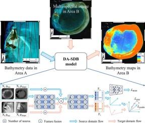
准确的水深数据对保护海洋生态系统和各种人类活动至关重要。基于经验方法的卫星水深测量(SDB)已被广泛应用于浅水深度估算。然而,经验方法是依赖于特定数据的回归模型,在不同时空域的泛化方面面临挑战。这些挑战可归因于水质、基质和大气条件变化引起的域转移。这种限制阻碍了它们在大规模或长期监控应用程序中的可伸缩性。在本文中,我们提出了一种基于领域自适应的卫星衍生测深(DA-SDB)深度学习模型来解决这一局限性。具体来说,DA-SDB模型包括三个组成部分:特征提取器、测深预测器和区域对准器。该特征提取器将金字塔样块(PLB)和物理辅助块(PAB)相结合,提高了数据利用率并提取了域不变特征。域对齐器通过对齐伪逆格拉姆矩阵来减轻域移位。在东沙环礁、比米尼岛、南沃登礁、哈德拉岛、穆巴拉兹岛和布提纳岛等5个不同的研究区域进行了时空转移实验。与现有方法相比,DA-SDB模型在泛化能力(均方根误差(RMSE)和平均绝对百分比误差(MAPE)分别降低了0.27 m和21.51%)和稳定性(12个最佳结果中有11个最佳结果)方面均有显著提高。值得注意的是,DA-SDB模型在很宽的深度范围内保持了很高的精度,与参考水深测量结果一致。它采用大气顶(TOA)反射率数据集,无需大气校正即可获得有效的结果。利用这种深度学习方法,可以快速、经济地进行偏远地区的水深测绘和关键地区的长期监测。本文章由计算机程序翻译,如有差异,请以英文原文为准。
Generalized satellite-derived bathymetry across spatial and temporal domains: a domain-adaptive deep learning approach with multi-source remote sensing data
Accurate bathymetric data are crucial for the protection of marine ecosystems and for various human activities. Satellite-derived bathymetry (SDB) based on an empirical approach has been widely employed to estimate shallow water depths. However, the empirical approaches are regression models dependent on specific data, facing challenges in generalizing across different spatial and temporal domains. These challenges can be attributed to domain shifts caused by variations in water quality, substrate, and atmospheric conditions. This limitation hampers their scalability for large-scale or long-term monitoring applications. In this paper, we propose a domain adaptation-based deep learning model for satellite-derived bathymetry (DA-SDB) to address the limitations. Specifically, the DA-SDB model comprises three components: a feature extractor, a bathymetry predictor, and a domain aligner. The feature extractor integrates a pyramid-like block (PLB) and a physical-assisted block (PAB) to improve the data utilization and extract domain-invariant features. The domain aligner mitigates domain shift by aligning the pseudo-inverse Gram matrices. We conducted spatial and temporal transfer experiments in five diverse study areas (Dongsha Atoll, Bimini Island, South Warden Reef, Hadrah Island, and Mubarraz and Bu Tinah Islands). The DA-SDB model demonstrated significant improvements in generalization ability (with the root-mean-square error (RMSE) and mean absolute percentage error (MAPE) reduced by 0.27 m and 21.51 %, respectively) and stability (achieving 11 out of 12 best results) over the state-of-the-art methods. Notably, the DA-SDB model maintains robust accuracy across a wide range of depths, as shown by its agreement with reference bathymetry. It employs a top-of-atmosphere (TOA) reflectance dataset and achieves effective results without atmospheric correction. Utilizing this deep learning method, the bathymetric mapping of remote areas and long-term monitoring of critical regions can be conducted rapidly and cost-effectively.
求助全文
通过发布文献求助,成功后即可免费获取论文全文。
去求助
来源期刊

ISPRS Journal of Photogrammetry and Remote Sensing
工程技术-成像科学与照相技术
CiteScore
21.00
自引率
6.30%
发文量
273
审稿时长
40 days
期刊介绍:
The ISPRS Journal of Photogrammetry and Remote Sensing (P&RS) serves as the official journal of the International Society for Photogrammetry and Remote Sensing (ISPRS). It acts as a platform for scientists and professionals worldwide who are involved in various disciplines that utilize photogrammetry, remote sensing, spatial information systems, computer vision, and related fields. The journal aims to facilitate communication and dissemination of advancements in these disciplines, while also acting as a comprehensive source of reference and archive.
P&RS endeavors to publish high-quality, peer-reviewed research papers that are preferably original and have not been published before. These papers can cover scientific/research, technological development, or application/practical aspects. Additionally, the journal welcomes papers that are based on presentations from ISPRS meetings, as long as they are considered significant contributions to the aforementioned fields.
In particular, P&RS encourages the submission of papers that are of broad scientific interest, showcase innovative applications (especially in emerging fields), have an interdisciplinary focus, discuss topics that have received limited attention in P&RS or related journals, or explore new directions in scientific or professional realms. It is preferred that theoretical papers include practical applications, while papers focusing on systems and applications should include a theoretical background.
 求助内容:
求助内容: 应助结果提醒方式:


