Lihong Zhang, Yan Liu, Lu Jin, Xiang-Yu Hou, Sandra Diminic, Xiaoyun Zhou, Shuichi Suetani, Carmel Nelson, Roxanne Bainbridge
{"title":"澳大利亚昆士兰东南部土著社区控制的精神卫生服务可及性方面的社会空间不平等。","authors":"Lihong Zhang, Yan Liu, Lu Jin, Xiang-Yu Hou, Sandra Diminic, Xiaoyun Zhou, Shuichi Suetani, Carmel Nelson, Roxanne Bainbridge","doi":"10.1186/s12942-025-00415-9","DOIUrl":null,"url":null,"abstract":"<p><strong>Background: </strong>Mental disorders significantly burden Indigenous communities, worsened by limited culturally appropriate services. Spatial inequalities in access further disadvantage Indigenous peoples, especially in socio-economically challenged areas. This paper measures the spatial accessibility of Indigenous community-controlled mental health services in South East Queensland, Australia and examines its social inequalities across the region.</p><p><strong>Methods: </strong>We considered both population and health service providers' capacity to maximise service coverage in measuring potential access to the services. Using Geographical Information Systems (GIS) technologies, a Gaussian-based two-step floating catchment area (G2SFCA) method was applied to quantify accessibility under four driving time thresholds ranging from 15 to 60 minutes. Bivariate global and local Moran's I statistics were used to analyse social inequalities in accessibility across various geographical areas.</p><p><strong>Results: </strong>Accessibility was higher in urban areas than those towards the peri-urban and rural areas; the overall spatial coverage was relatively limited for service access within the 15- or 30-minute driving time threshold, compared with the 45- or 60-minute driving time threshold. Lower levels of accessibility were identified in areas with a concentration of Indigenous and socio-economically disadvantaged populations.</p><p><strong>Conclusions: </strong>This study advances a socially informed spatial inequality assessment framework. Unlike previous research exploring accessibility qualitatively, our framework innovatively integrates spatial analysis, Indigenous-specific population data and culturally sensitive provider capacity metrics within an advanced G2SFCA model. This approach uniquely exposes the compounded socio-spatial barriers to mental health services for Indigenous populations across South East Queensland's urban-rural continuum. The resulting accessibility and inequality maps, combined with a summary of focus areas and their associated socio-demographic profiles, provide a direct policy lever to prioritise intervention for Indigenous communities experiencing the greatest disadvantage. By bridging spatial analysis with Indigenous cultural contexts, this work offers a replicable model for equitable, community-driven healthcare resource allocation for Indigenous peoples globally.</p>","PeriodicalId":48739,"journal":{"name":"International Journal of Health Geographics","volume":"24 1","pages":"24"},"PeriodicalIF":3.0000,"publicationDate":"2025-09-26","publicationTypes":"Journal Article","fieldsOfStudy":null,"isOpenAccess":false,"openAccessPdf":"https://www.ncbi.nlm.nih.gov/pmc/articles/PMC12465140/pdf/","citationCount":"0","resultStr":"{\"title\":\"Socio-spatial inequalities in accessibility of Indigenous community-controlled mental health services in South East Queensland, Australia.\",\"authors\":\"Lihong Zhang, Yan Liu, Lu Jin, Xiang-Yu Hou, Sandra Diminic, Xiaoyun Zhou, Shuichi Suetani, Carmel Nelson, Roxanne Bainbridge\",\"doi\":\"10.1186/s12942-025-00415-9\",\"DOIUrl\":null,\"url\":null,\"abstract\":\"<p><strong>Background: </strong>Mental disorders significantly burden Indigenous communities, worsened by limited culturally appropriate services. Spatial inequalities in access further disadvantage Indigenous peoples, especially in socio-economically challenged areas. This paper measures the spatial accessibility of Indigenous community-controlled mental health services in South East Queensland, Australia and examines its social inequalities across the region.</p><p><strong>Methods: </strong>We considered both population and health service providers' capacity to maximise service coverage in measuring potential access to the services. Using Geographical Information Systems (GIS) technologies, a Gaussian-based two-step floating catchment area (G2SFCA) method was applied to quantify accessibility under four driving time thresholds ranging from 15 to 60 minutes. Bivariate global and local Moran's I statistics were used to analyse social inequalities in accessibility across various geographical areas.</p><p><strong>Results: </strong>Accessibility was higher in urban areas than those towards the peri-urban and rural areas; the overall spatial coverage was relatively limited for service access within the 15- or 30-minute driving time threshold, compared with the 45- or 60-minute driving time threshold. Lower levels of accessibility were identified in areas with a concentration of Indigenous and socio-economically disadvantaged populations.</p><p><strong>Conclusions: </strong>This study advances a socially informed spatial inequality assessment framework. Unlike previous research exploring accessibility qualitatively, our framework innovatively integrates spatial analysis, Indigenous-specific population data and culturally sensitive provider capacity metrics within an advanced G2SFCA model. This approach uniquely exposes the compounded socio-spatial barriers to mental health services for Indigenous populations across South East Queensland's urban-rural continuum. The resulting accessibility and inequality maps, combined with a summary of focus areas and their associated socio-demographic profiles, provide a direct policy lever to prioritise intervention for Indigenous communities experiencing the greatest disadvantage. By bridging spatial analysis with Indigenous cultural contexts, this work offers a replicable model for equitable, community-driven healthcare resource allocation for Indigenous peoples globally.</p>\",\"PeriodicalId\":48739,\"journal\":{\"name\":\"International Journal of Health Geographics\",\"volume\":\"24 1\",\"pages\":\"24\"},\"PeriodicalIF\":3.0000,\"publicationDate\":\"2025-09-26\",\"publicationTypes\":\"Journal Article\",\"fieldsOfStudy\":null,\"isOpenAccess\":false,\"openAccessPdf\":\"https://www.ncbi.nlm.nih.gov/pmc/articles/PMC12465140/pdf/\",\"citationCount\":\"0\",\"resultStr\":null,\"platform\":\"Semanticscholar\",\"paperid\":null,\"PeriodicalName\":\"International Journal of Health Geographics\",\"FirstCategoryId\":\"3\",\"ListUrlMain\":\"https://doi.org/10.1186/s12942-025-00415-9\",\"RegionNum\":2,\"RegionCategory\":\"医学\",\"ArticlePicture\":[],\"TitleCN\":null,\"AbstractTextCN\":null,\"PMCID\":null,\"EPubDate\":\"\",\"PubModel\":\"\",\"JCR\":\"Q2\",\"JCRName\":\"PUBLIC, ENVIRONMENTAL & OCCUPATIONAL HEALTH\",\"Score\":null,\"Total\":0}","platform":"Semanticscholar","paperid":null,"PeriodicalName":"International Journal of Health Geographics","FirstCategoryId":"3","ListUrlMain":"https://doi.org/10.1186/s12942-025-00415-9","RegionNum":2,"RegionCategory":"医学","ArticlePicture":[],"TitleCN":null,"AbstractTextCN":null,"PMCID":null,"EPubDate":"","PubModel":"","JCR":"Q2","JCRName":"PUBLIC, ENVIRONMENTAL & OCCUPATIONAL HEALTH","Score":null,"Total":0}
Socio-spatial inequalities in accessibility of Indigenous community-controlled mental health services in South East Queensland, Australia.
Background: Mental disorders significantly burden Indigenous communities, worsened by limited culturally appropriate services. Spatial inequalities in access further disadvantage Indigenous peoples, especially in socio-economically challenged areas. This paper measures the spatial accessibility of Indigenous community-controlled mental health services in South East Queensland, Australia and examines its social inequalities across the region.
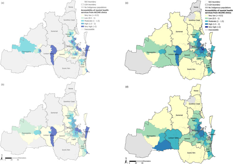
Methods: We considered both population and health service providers' capacity to maximise service coverage in measuring potential access to the services. Using Geographical Information Systems (GIS) technologies, a Gaussian-based two-step floating catchment area (G2SFCA) method was applied to quantify accessibility under four driving time thresholds ranging from 15 to 60 minutes. Bivariate global and local Moran's I statistics were used to analyse social inequalities in accessibility across various geographical areas.
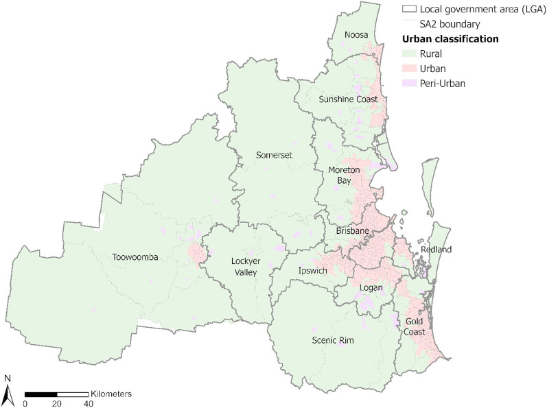
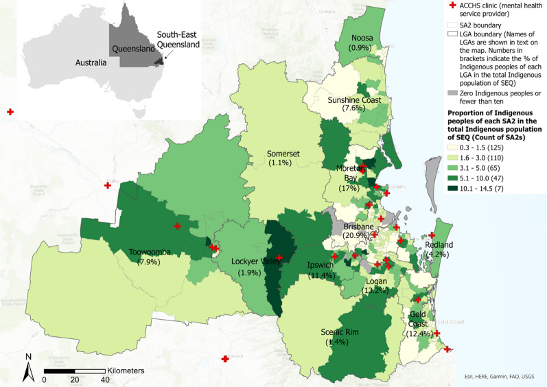
Results: Accessibility was higher in urban areas than those towards the peri-urban and rural areas; the overall spatial coverage was relatively limited for service access within the 15- or 30-minute driving time threshold, compared with the 45- or 60-minute driving time threshold. Lower levels of accessibility were identified in areas with a concentration of Indigenous and socio-economically disadvantaged populations.
Conclusions: This study advances a socially informed spatial inequality assessment framework. Unlike previous research exploring accessibility qualitatively, our framework innovatively integrates spatial analysis, Indigenous-specific population data and culturally sensitive provider capacity metrics within an advanced G2SFCA model. This approach uniquely exposes the compounded socio-spatial barriers to mental health services for Indigenous populations across South East Queensland's urban-rural continuum. The resulting accessibility and inequality maps, combined with a summary of focus areas and their associated socio-demographic profiles, provide a direct policy lever to prioritise intervention for Indigenous communities experiencing the greatest disadvantage. By bridging spatial analysis with Indigenous cultural contexts, this work offers a replicable model for equitable, community-driven healthcare resource allocation for Indigenous peoples globally.
期刊介绍:
A leader among the field, International Journal of Health Geographics is an interdisciplinary, open access journal publishing internationally significant studies of geospatial information systems and science applications in health and healthcare. With an exceptional author satisfaction rate and a quick time to first decision, the journal caters to readers across an array of healthcare disciplines globally.
International Journal of Health Geographics welcomes novel studies in the health and healthcare context spanning from spatial data infrastructure and Web geospatial interoperability research, to research into real-time Geographic Information Systems (GIS)-enabled surveillance services, remote sensing applications, spatial epidemiology, spatio-temporal statistics, internet GIS and cyberspace mapping, participatory GIS and citizen sensing, geospatial big data, healthy smart cities and regions, and geospatial Internet of Things and blockchain.
 求助内容:
求助内容: 应助结果提醒方式:


