{"title":"根据现代地球引力场卫星模型数据估计运动物体坐标的潜在误差","authors":"G. E. Valov, P. S. Mikhailov, V. N. Koneshov","doi":"10.1134/S1069351325700041","DOIUrl":null,"url":null,"abstract":"<p>The article studies the possibility and accuracy of correcting the coordinates of a moving object according to data of a modern satellite model of the Earth’s gravitational field. A software implementation of modeling the readings of strapdown inertial navigation systems (SINS) is presented. Based on an analysis of various sources and modeling of the route corresponding to a real marine scientific expedition, the optimal parameters of the SINS modules were obtained. An algorithm for refining the coordinate position of a moving object based on the coordinate descent method is proposed. Regression analysis was used to derive a formula for the relationship between the mean square error of the gravimetric map and the horizontal gradient of the gravity anomaly (GA). A number of experiments were carried out to refine the coordinate position in areas characterized by different GA gradients with modeling of the errors of the relative gravimeter and gravimetric map. As a result of experiments, it was found that it is possible to determine the coordinate position according to model gravity data with an accuracy of 100–1900 m in areas with “large” GA gradients (from 2 to 6 mGal/km) and from 100 to 6400 m in areas with “small” GA gradients (up to 2 mGal/km), depending on the type and magnitude of the errors.</p>","PeriodicalId":602,"journal":{"name":"Izvestiya, Physics of the Solid Earth","volume":"61 1","pages":"115 - 125"},"PeriodicalIF":1.0000,"publicationDate":"2025-07-18","publicationTypes":"Journal Article","fieldsOfStudy":null,"isOpenAccess":false,"openAccessPdf":"","citationCount":"0","resultStr":"{\"title\":\"Estimation of the Potential Error in Refining the Coordinates of a Moving Object according to Data of a Modern Satellite Model of the Earth’s Gravitational Field\",\"authors\":\"G. E. Valov, P. S. Mikhailov, V. N. Koneshov\",\"doi\":\"10.1134/S1069351325700041\",\"DOIUrl\":null,\"url\":null,\"abstract\":\"<p>The article studies the possibility and accuracy of correcting the coordinates of a moving object according to data of a modern satellite model of the Earth’s gravitational field. A software implementation of modeling the readings of strapdown inertial navigation systems (SINS) is presented. Based on an analysis of various sources and modeling of the route corresponding to a real marine scientific expedition, the optimal parameters of the SINS modules were obtained. An algorithm for refining the coordinate position of a moving object based on the coordinate descent method is proposed. Regression analysis was used to derive a formula for the relationship between the mean square error of the gravimetric map and the horizontal gradient of the gravity anomaly (GA). A number of experiments were carried out to refine the coordinate position in areas characterized by different GA gradients with modeling of the errors of the relative gravimeter and gravimetric map. As a result of experiments, it was found that it is possible to determine the coordinate position according to model gravity data with an accuracy of 100–1900 m in areas with “large” GA gradients (from 2 to 6 mGal/km) and from 100 to 6400 m in areas with “small” GA gradients (up to 2 mGal/km), depending on the type and magnitude of the errors.</p>\",\"PeriodicalId\":602,\"journal\":{\"name\":\"Izvestiya, Physics of the Solid Earth\",\"volume\":\"61 1\",\"pages\":\"115 - 125\"},\"PeriodicalIF\":1.0000,\"publicationDate\":\"2025-07-18\",\"publicationTypes\":\"Journal Article\",\"fieldsOfStudy\":null,\"isOpenAccess\":false,\"openAccessPdf\":\"\",\"citationCount\":\"0\",\"resultStr\":null,\"platform\":\"Semanticscholar\",\"paperid\":null,\"PeriodicalName\":\"Izvestiya, Physics of the Solid Earth\",\"FirstCategoryId\":\"89\",\"ListUrlMain\":\"https://link.springer.com/article/10.1134/S1069351325700041\",\"RegionNum\":4,\"RegionCategory\":\"地球科学\",\"ArticlePicture\":[],\"TitleCN\":null,\"AbstractTextCN\":null,\"PMCID\":null,\"EPubDate\":\"\",\"PubModel\":\"\",\"JCR\":\"Q4\",\"JCRName\":\"GEOCHEMISTRY & GEOPHYSICS\",\"Score\":null,\"Total\":0}","platform":"Semanticscholar","paperid":null,"PeriodicalName":"Izvestiya, Physics of the Solid Earth","FirstCategoryId":"89","ListUrlMain":"https://link.springer.com/article/10.1134/S1069351325700041","RegionNum":4,"RegionCategory":"地球科学","ArticlePicture":[],"TitleCN":null,"AbstractTextCN":null,"PMCID":null,"EPubDate":"","PubModel":"","JCR":"Q4","JCRName":"GEOCHEMISTRY & GEOPHYSICS","Score":null,"Total":0}
Estimation of the Potential Error in Refining the Coordinates of a Moving Object according to Data of a Modern Satellite Model of the Earth’s Gravitational Field
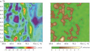
The article studies the possibility and accuracy of correcting the coordinates of a moving object according to data of a modern satellite model of the Earth’s gravitational field. A software implementation of modeling the readings of strapdown inertial navigation systems (SINS) is presented. Based on an analysis of various sources and modeling of the route corresponding to a real marine scientific expedition, the optimal parameters of the SINS modules were obtained. An algorithm for refining the coordinate position of a moving object based on the coordinate descent method is proposed. Regression analysis was used to derive a formula for the relationship between the mean square error of the gravimetric map and the horizontal gradient of the gravity anomaly (GA). A number of experiments were carried out to refine the coordinate position in areas characterized by different GA gradients with modeling of the errors of the relative gravimeter and gravimetric map. As a result of experiments, it was found that it is possible to determine the coordinate position according to model gravity data with an accuracy of 100–1900 m in areas with “large” GA gradients (from 2 to 6 mGal/km) and from 100 to 6400 m in areas with “small” GA gradients (up to 2 mGal/km), depending on the type and magnitude of the errors.
期刊介绍:
Izvestiya, Physics of the Solid Earth is an international peer reviewed journal that publishes results of original theoretical and experimental research in relevant areas of the physics of the Earth''s interior and applied geophysics. The journal welcomes manuscripts from all countries in the English or Russian language.
 求助内容:
求助内容: 应助结果提醒方式:


