遥感、国家森林清查和行政调查系统提供的采伐统计数据的综合分析:来自意大利的一个例子
IF 8.6
Q1 REMOTE SENSING
International journal of applied earth observation and geoinformation : ITC journal
Pub Date : 2025-09-24
DOI:10.1016/j.jag.2025.104871
引用次数: 0
摘要
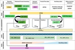
森林是实现欧盟气候中和目标的关键因素,但自然干扰、气候变化和人类活动,使得建立一个影响森林生态系统主要参数的连续监测系统迫在眉睫。一个关键参数是年砍伐量:在给定的参考期间砍伐的树木量。我们将基于直接实地测量的国家森林清查数据与通过遥感获得的年度时间序列数据相结合,以评估2000年至2023年间意大利进行的砍伐量。意大利被选为代表性案例研究,因为收获统计数据缺失或部分不一致,这也是其他欧洲国家的情况。我们强调,没有任何数据源,单独考虑,可以提供一个全面的估计收获水平及其演变的时间。2000年至2023年间,森林砍伐总量从2006年1650万立方米的峰值到2014年1040万立方米的低点不等。对采伐水平的近实时评估,如我们研究中估计的,对于量化人类活动对森林生态系统的影响越来越重要。根据我们的研究结果,最近几年的森林砍伐率,即森林砍伐与增量的比率,约为0.38。然而,考虑到所有输入数据的不确定性,总感觉在±50%左右,相应的感觉率可能会明显更大。由此产生了迫切需要建立一个持续监测系统,不仅在意大利,而且在整个欧盟可靠地整合国家森林清查调查和遥感数据。本文章由计算机程序翻译,如有差异,请以英文原文为准。
Integrated analysis of harvest statistics provided by remote sensing, national forest inventories and administrative survey systems: An example from Italy
Forests are a key element for reaching the EU climate neutrality targets, but natural disturbances, climate change and human activities, make it urgent to set up a continuous monitoring system of the main parameters affecting forest ecosystems. A key parameter is the annual felling: the volume of trees felled during a given reference period.
We combine National Forest Inventory data, based on direct field measurements, with yearly time series data derived by remote sensing, to assess the amount of fellings carried out in Italy between 2000 and 2023. Italy was selected as a representative case study as harvest statistics are missing or partially inconsistent, which is also the case for other European countries.
We highlighted that no data source, considered individually, can provide a comprehensive estimate of the harvest level and its evolution in time.
Between 2000 and 2023, total fellings ranged from a peak of 16.5 million m3 in 2006 to a low of 10.4 million m3 in 2014.
A near real-time assessment of the harvest level, such as estimated within our study, is increasingly important to quantify the impact of human activities on forest ecosystems. According to our results, the fellings rate, i.e. the ratio between fellings and increment, was about 0.38 within the latest years. Nevertheless, considering the uncertainty of all input data, the total fellings ranged by about ± 50 %, and the corresponding fellings rate could be significantly larger. From this arises the urgent need to set up a continuous monitoring system, integrating National Forest Inventory surveys and remote sensing data reliably, not only in Italy, but across the EU.
求助全文
通过发布文献求助,成功后即可免费获取论文全文。
去求助
来源期刊

International journal of applied earth observation and geoinformation : ITC journal
Global and Planetary Change, Management, Monitoring, Policy and Law, Earth-Surface Processes, Computers in Earth Sciences
CiteScore
12.00
自引率
0.00%
发文量
0
审稿时长
77 days
期刊介绍:
The International Journal of Applied Earth Observation and Geoinformation publishes original papers that utilize earth observation data for natural resource and environmental inventory and management. These data primarily originate from remote sensing platforms, including satellites and aircraft, supplemented by surface and subsurface measurements. Addressing natural resources such as forests, agricultural land, soils, and water, as well as environmental concerns like biodiversity, land degradation, and hazards, the journal explores conceptual and data-driven approaches. It covers geoinformation themes like capturing, databasing, visualization, interpretation, data quality, and spatial uncertainty.
 求助内容:
求助内容: 应助结果提醒方式:


