Abdelhakim Eshanibli , Nur Azwin Ismail , Hussin B. Ghanush , Abdullatif Dugdug , Osagie Abel Uyimwen , Nabil Khalifa , Abed Alrauf M. Aushah , Khiri A. Khalf
{"title":"利比亚锡尔特盆地西部Gerad地堑基底和地下构造深度的重磁资料圈定","authors":"Abdelhakim Eshanibli , Nur Azwin Ismail , Hussin B. Ghanush , Abdullatif Dugdug , Osagie Abel Uyimwen , Nabil Khalifa , Abed Alrauf M. Aushah , Khiri A. Khalf","doi":"10.1016/j.engeos.2025.100468","DOIUrl":null,"url":null,"abstract":"<div><div>This study integrates gravity and aeromagnetic datasets to delineate basement depth and characterise the subsurface structural framework of the Gerad Graben in the western Sirt Basin, Libya. Techniques including high-pass filtering, Centre for Exploration Targeting (CET) edge detection, Source Parameter Imaging (SPI), and Euler Deconvolution (ED) were applied to residual gravity and residual reduced-to-pole (RTP) magnetic data to enhance fault mapping and basement morphology. Tests of various cutoff wavelengths show that 10 km for gravity and 15 km for magnetic data provide optimal resolution of shallow structures while preserving deeper trends. Forward 2D GM-SYS modelling and Werner Deconvolution further constrained the geometry and depth of intrusive bodies and fault systems. Results reveal a structurally complex graben with NE-SW, NW-SE, ENE-WSW, and N-S trending faults, indicating multiphase tectonic deformation. Graben-bounding faults show displacement values of 600–4290 m, and basement depths in the central depocenter reach 4275–4300 m, validated by well NTF-50. Magnetic anomalies indicate intrusive igneous bodies, including NW-SE-trending sills and dikes, associated with the Tibesti and Al Haruj volcanic provinces. These intrusions likely caused localised heating, uplift, and fault reactivation. The integrated interpretation supports a tectono-magmatic evolution involving successive rifting phases from the Paleozoic to Cenozoic, influenced by inherited Precambrian structures. These features, coupled with substantial sediment infill and magmatic activity, enhance the hydrocarbon potential of the Gerad Graben, suggesting the presence of structural and stratigraphic traps within the broader of Sirt Basin petroleum system.</div></div>","PeriodicalId":100469,"journal":{"name":"Energy Geoscience","volume":"6 4","pages":"Article 100468"},"PeriodicalIF":3.6000,"publicationDate":"2025-09-16","publicationTypes":"Journal Article","fieldsOfStudy":null,"isOpenAccess":false,"openAccessPdf":"","citationCount":"0","resultStr":"{\"title\":\"Delineation of depth to basement and subsurface structures beneath the Gerad Graben, western Sirt Basin, Libya, from gravity and aeromagnetic data\",\"authors\":\"Abdelhakim Eshanibli , Nur Azwin Ismail , Hussin B. Ghanush , Abdullatif Dugdug , Osagie Abel Uyimwen , Nabil Khalifa , Abed Alrauf M. Aushah , Khiri A. Khalf\",\"doi\":\"10.1016/j.engeos.2025.100468\",\"DOIUrl\":null,\"url\":null,\"abstract\":\"<div><div>This study integrates gravity and aeromagnetic datasets to delineate basement depth and characterise the subsurface structural framework of the Gerad Graben in the western Sirt Basin, Libya. Techniques including high-pass filtering, Centre for Exploration Targeting (CET) edge detection, Source Parameter Imaging (SPI), and Euler Deconvolution (ED) were applied to residual gravity and residual reduced-to-pole (RTP) magnetic data to enhance fault mapping and basement morphology. Tests of various cutoff wavelengths show that 10 km for gravity and 15 km for magnetic data provide optimal resolution of shallow structures while preserving deeper trends. Forward 2D GM-SYS modelling and Werner Deconvolution further constrained the geometry and depth of intrusive bodies and fault systems. Results reveal a structurally complex graben with NE-SW, NW-SE, ENE-WSW, and N-S trending faults, indicating multiphase tectonic deformation. Graben-bounding faults show displacement values of 600–4290 m, and basement depths in the central depocenter reach 4275–4300 m, validated by well NTF-50. Magnetic anomalies indicate intrusive igneous bodies, including NW-SE-trending sills and dikes, associated with the Tibesti and Al Haruj volcanic provinces. These intrusions likely caused localised heating, uplift, and fault reactivation. The integrated interpretation supports a tectono-magmatic evolution involving successive rifting phases from the Paleozoic to Cenozoic, influenced by inherited Precambrian structures. These features, coupled with substantial sediment infill and magmatic activity, enhance the hydrocarbon potential of the Gerad Graben, suggesting the presence of structural and stratigraphic traps within the broader of Sirt Basin petroleum system.</div></div>\",\"PeriodicalId\":100469,\"journal\":{\"name\":\"Energy Geoscience\",\"volume\":\"6 4\",\"pages\":\"Article 100468\"},\"PeriodicalIF\":3.6000,\"publicationDate\":\"2025-09-16\",\"publicationTypes\":\"Journal Article\",\"fieldsOfStudy\":null,\"isOpenAccess\":false,\"openAccessPdf\":\"\",\"citationCount\":\"0\",\"resultStr\":null,\"platform\":\"Semanticscholar\",\"paperid\":null,\"PeriodicalName\":\"Energy Geoscience\",\"FirstCategoryId\":\"1085\",\"ListUrlMain\":\"https://www.sciencedirect.com/science/article/pii/S2666759225000897\",\"RegionNum\":0,\"RegionCategory\":null,\"ArticlePicture\":[],\"TitleCN\":null,\"AbstractTextCN\":null,\"PMCID\":null,\"EPubDate\":\"\",\"PubModel\":\"\",\"JCR\":\"\",\"JCRName\":\"\",\"Score\":null,\"Total\":0}","platform":"Semanticscholar","paperid":null,"PeriodicalName":"Energy Geoscience","FirstCategoryId":"1085","ListUrlMain":"https://www.sciencedirect.com/science/article/pii/S2666759225000897","RegionNum":0,"RegionCategory":null,"ArticlePicture":[],"TitleCN":null,"AbstractTextCN":null,"PMCID":null,"EPubDate":"","PubModel":"","JCR":"","JCRName":"","Score":null,"Total":0}
Delineation of depth to basement and subsurface structures beneath the Gerad Graben, western Sirt Basin, Libya, from gravity and aeromagnetic data
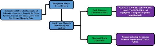
This study integrates gravity and aeromagnetic datasets to delineate basement depth and characterise the subsurface structural framework of the Gerad Graben in the western Sirt Basin, Libya. Techniques including high-pass filtering, Centre for Exploration Targeting (CET) edge detection, Source Parameter Imaging (SPI), and Euler Deconvolution (ED) were applied to residual gravity and residual reduced-to-pole (RTP) magnetic data to enhance fault mapping and basement morphology. Tests of various cutoff wavelengths show that 10 km for gravity and 15 km for magnetic data provide optimal resolution of shallow structures while preserving deeper trends. Forward 2D GM-SYS modelling and Werner Deconvolution further constrained the geometry and depth of intrusive bodies and fault systems. Results reveal a structurally complex graben with NE-SW, NW-SE, ENE-WSW, and N-S trending faults, indicating multiphase tectonic deformation. Graben-bounding faults show displacement values of 600–4290 m, and basement depths in the central depocenter reach 4275–4300 m, validated by well NTF-50. Magnetic anomalies indicate intrusive igneous bodies, including NW-SE-trending sills and dikes, associated with the Tibesti and Al Haruj volcanic provinces. These intrusions likely caused localised heating, uplift, and fault reactivation. The integrated interpretation supports a tectono-magmatic evolution involving successive rifting phases from the Paleozoic to Cenozoic, influenced by inherited Precambrian structures. These features, coupled with substantial sediment infill and magmatic activity, enhance the hydrocarbon potential of the Gerad Graben, suggesting the presence of structural and stratigraphic traps within the broader of Sirt Basin petroleum system.

 求助内容:
求助内容: 应助结果提醒方式:


