基于TanDEM-X的喀喇昆仑地区大地冰川物质平衡(2011-2019):InSAR DEM差异框架
IF 11.4
1区 地球科学
Q1 ENVIRONMENTAL SCIENCES
引用次数: 0
摘要
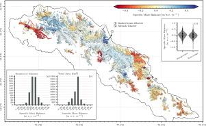
冰川是气候变化的敏感指标,既影响区域供水,也影响全球海平面上升。与全球退缩的趋势相反,喀喇昆仑的冰川呈现出一种不寻常的稳定模式和适度的增厚。然而,由于以往测量方法的局限性,人们对质量平衡异常的空间变异性和潜在原因仍然知之甚少。为了弥补这一差距,我们对喀喇昆仑中东部的冰川高程变化进行了全面的大地测量分析,覆盖了2011年至2019年期间面积超过1万平方公里的681座冰川。海拔高度完全由TanDEM-X InSAR数据测量,以减少穿透偏差和时间模糊性。采用三模块DEM差分框架进行大地测量分析。在此框架中,第一个模块通过迭代方法生成高质量的InSAR DEM,以解决山区地形对InSAR处理的挑战;第二个模块采用了一种创新的高斯过程回归填充方法进行鲁棒高程变化制图;第三个模块采用非平稳不确定性分析进行严格的不确定性量化。结果表明,区域平均高程变化率为0.0038±0.0042myr - 10.0038±0.0042myr - 1,比质量平衡为0.0032±0.0052mw. e.r - 10.0032±0.0052mw.e。Yr−1,表明在研究期间整体略有增厚。高程变化的空间格局表现出明显的异质性,激流型和非激流型冰川之间存在明显差异,反映了该地区动力、气候和形态因素的复杂相互作用。该研究证明了高分辨率andme - x InSAR DEM在具有挑战性的山区环境中进行精确大地质量平衡分析的能力。提出的框架为未来大规模冰川研究提供了一种可扩展的方法。本文章由计算机程序翻译,如有差异,请以英文原文为准。

Geodetic glacier mass balance in the Karakoram (2011–2019) from TanDEM-X: An InSAR DEM differencing framework
Glaciers serve as sensitive indicators of climate change, influencing both regional water supplies and global sea-level rise. Contrasting to the global tendency towards retreat, glaciers in the Karakoram exhibits an unusual pattern of stability and modest thickening. However, the spatial variability and underlying causes of the mass balance anomalies remain insufficiently understood, primarily due to the limitations in previous measurement methods. To address this gap, we conducted a comprehensive geodetic analysis of glacier elevation changes in the central and eastern Karakoram, covering 681 glaciers of over 10,000 km2 between 2011 and 2019. The elevation was measured exclusively with TanDEM-X InSAR data to reduce penetration bias and temporal ambiguities. The geodetic analysis was conducted using a three-module DEM Differencing framework. In this framework, the first module generates high-quality InSAR DEM with an iterative approach to address the challenges of mountainous terrain for InSAR processing; the second module employed an innovative voids filling method using Gaussian Process Regression for robust elevation change mapping; and the third module incorporates a non-stationary uncertainty analysis for rigorous uncertainty quantification. The results reveal a regional mean elevation change rate of and a specific mass balance of , indicating slight overall thickening during the study period. The spatial patterns of elevation change display pronounced heterogeneity and clear differences between surge-type and non-surge glaciers, reflecting the complex interplay of dynamic, climatic, and morphological factors in the region. This study demonstrates the capability of high-resolution TanDME-X InSAR DEM for accurate geodetic mass balance analysis in challenging mountain environments. The proposed framework provides a scalable methodology for future large-scale glacier studies.
求助全文
通过发布文献求助,成功后即可免费获取论文全文。
去求助
来源期刊

Remote Sensing of Environment
环境科学-成像科学与照相技术
CiteScore
25.10
自引率
8.90%
发文量
455
审稿时长
53 days
期刊介绍:
Remote Sensing of Environment (RSE) serves the Earth observation community by disseminating results on the theory, science, applications, and technology that contribute to advancing the field of remote sensing. With a thoroughly interdisciplinary approach, RSE encompasses terrestrial, oceanic, and atmospheric sensing.
The journal emphasizes biophysical and quantitative approaches to remote sensing at local to global scales, covering a diverse range of applications and techniques.
RSE serves as a vital platform for the exchange of knowledge and advancements in the dynamic field of remote sensing.
 求助内容:
求助内容: 应助结果提醒方式:


