基于语义分割的无人机图像农田地块提取与面积计算
IF 4.5
Q2 ENVIRONMENTAL SCIENCES
Remote Sensing Applications-Society and Environment
Pub Date : 2025-09-19
DOI:10.1016/j.rsase.2025.101734
引用次数: 0
摘要
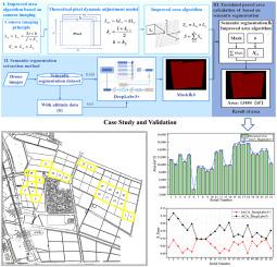
在智慧农业灌溉管理中,准确高效的农田面积计算是至关重要的组成部分,可以显著促进水资源配置的优化和农业生产效率的提高。提出了一种基于语义分割的无人机图像农田地块提取与面积计算方法。首先,基于相机成像原理建立理论动态像元平差模型,改进农田地块面积的计算方法;然后,采用语义分割的方法从无人机图像中提取农田地块,提高面积计算效率;最后,利用自建农田地块数据集和多高度航空影像数据集,验证了所提方法及其改进算法的准确性和适用性。实验结果表明,地块分割的精度与面积计算方法的精度是相互影响的,其相对重要性在工作流程的不同阶段有所不同,该方法显著提高了农田地块面积的计算精度和效率。在农田地块提取任务中,基于Deeplabv3+的语义分割模型取得了优异的成绩,测试集F1得分、Miou、OA、准确率和召回率分别为96.60%、95.67%、97.83%、97.95%和98.41%。改进算法在22 ~ 49m的空中高度范围内保持了1.2%的平均相对误差。在海拔84 ~ 121m范围内,与传统方法相比,均方误差(MSE)降低了84.56%,平均绝对误差(MAE)降低了64.46%。与实测面积数据的对比分析表明,该方法的面积计算误差严格控制在4%以内,满足农业工程精度标准。本文章由计算机程序翻译,如有差异,请以英文原文为准。
Farmland parcel extraction and area calculation from UAV images based on semantic segmentation
In irrigation management of smart farming, the accurate and efficient calculation of farmland parcel area is regarded as a critical component, by which the optimization of water resource allocation and the enhancement of agricultural production efficiency are significantly promoted. This study proposed a method for farmland parcel extraction and area calculation from Unmanned Aerial Vehicle (UAV) images based on semantic segmentation. First, a theoretical dynamic pixel adjustment model was established based on camera imaging principles to improve the calculation method for farmland parcel area. Then, farmland parcel extraction from UAV images was performed by semantic segmentation, through which the efficiency of area calculation was enhanced. Finally, verification of the proposed method and its improved algorithm’s accuracy and applicability was conducted by utilizing self-built farmland parcel datasets and multi-altitude aerial image datasets. Experimental results indicated that the accuracy of parcel segmentation and that of area calculation methods exert a mutual influence on each other, with their relative importance varying across different stages of the workflow and the calculation accuracy and efficiency of farmland parcel area was significantly improved by the proposed method. In the task of farmland parcel extraction, the semantic segmentation model based on Deeplabv3+ resulted excellent performance, achieving a test-set F1 score, Miou, OA, precision and recall of the test set are 96.60 %, 95.67 %, 97.83 %, 97.95 % and 98.41 %. An average relative error of 1.2 % is maintained by the improved algorithm across the aerial altitude range of 22–49m. In the range of 84–121m altitude, reductions of 84.56 % in mean squared error (MSE) and 64.46 % in mean absolute error (MAE) were achieved when compared with traditional methods. Comparative analysis with measured area data demonstrated that the area calculation error of the proposed method is strictly constrained within a 4 % threshold, satisfying with the precision standards of agricultural engineering.
求助全文
通过发布文献求助,成功后即可免费获取论文全文。
去求助
来源期刊

CiteScore
8.00
自引率
8.50%
发文量
204
审稿时长
65 days
期刊介绍:
The journal ''Remote Sensing Applications: Society and Environment'' (RSASE) focuses on remote sensing studies that address specific topics with an emphasis on environmental and societal issues - regional / local studies with global significance. Subjects are encouraged to have an interdisciplinary approach and include, but are not limited by: " -Global and climate change studies addressing the impact of increasing concentrations of greenhouse gases, CO2 emission, carbon balance and carbon mitigation, energy system on social and environmental systems -Ecological and environmental issues including biodiversity, ecosystem dynamics, land degradation, atmospheric and water pollution, urban footprint, ecosystem management and natural hazards (e.g. earthquakes, typhoons, floods, landslides) -Natural resource studies including land-use in general, biomass estimation, forests, agricultural land, plantation, soils, coral reefs, wetland and water resources -Agriculture, food production systems and food security outcomes -Socio-economic issues including urban systems, urban growth, public health, epidemics, land-use transition and land use conflicts -Oceanography and coastal zone studies, including sea level rise projections, coastlines changes and the ocean-land interface -Regional challenges for remote sensing application techniques, monitoring and analysis, such as cloud screening and atmospheric correction for tropical regions -Interdisciplinary studies combining remote sensing, household survey data, field measurements and models to address environmental, societal and sustainability issues -Quantitative and qualitative analysis that documents the impact of using remote sensing studies in social, political, environmental or economic systems
 求助内容:
求助内容: 应助结果提醒方式:


