{"title":"GEOV2-AVHRR: 1981 - 2022年全球叶面积指数和PAR吸收分数的连续一致时间序列","authors":"Aleixandre Verger , Marie Weiss , Frédéric Baret","doi":"10.1016/j.rse.2025.115029","DOIUrl":null,"url":null,"abstract":"<div><div>Long-term time series of global leaf area index (LAI) and fraction of absorbed photosynthetic active radiation (FAPAR) are required for characterizing vegetation dynamics in global change studies. The recently developed Copernicus Land Monitoring Service GEOV2-CLMS products were demonstrated to outperform other existing LAI and FAPAR products in terms of completeness, temporal smoothness, consistency across variables and accuracy. However, these GEOV2-CLMS products are derived from the SPOT/VGT and PROBA-V constellation with temporal coverage from 1999 to 2020 which limits its applicability for global change studies. We present here an adaptation of the GEOV2-CLMS algorithm to AVHRR to extend these time series and generate long-term global vegetation products from July 1981 to December 2022. The GEOV2-AVHRR algorithm was specifically designed to maximize the temporal consistency over the successive AVHRR sensors on board NOAA and MetOp-B satellites while keeping high agreement with GEOV2-CLMS products. Neural networks first transform AVHRR surface reflectance into LAI and FAPAR values at the daily time step. The daily estimates are then filtered, smoothed, gap filled and composited every 10-day.</div><div>GEOV2-AVHRR showed accuracy error between −0.2 and 0.3 LAI and ∼ −0.03 FAPAR and uncertainty <1 LAI and ∼ 0.10–0.15 for woody and non-woody sites of both DIRECT2.1 and GBOV V3 datasets. GEOV2-AVHRR agreed well with GEOV2-CLMS (MODIS): 92 % (76 %) of land pixels are within ±max(20 %, 0.5) LAI and 71 % (34 %) within ±max(10 %, 0.05) FAPAR uncertainty requirements. The gap filling and temporal filters applied in GEOV2-AVHRR proved effective in improving the completeness (only 1 % of missing data) and temporal precision (smoothness) of LAI and FAPAR time series as compared to MODIS. The intra-annual consistency of GEOV2-AVHRR highly agree with GEOV2-CLMS, indicating it is mostly driven by the algorithm. On the contrary, the inter-annual consistency of LAI and FAPAR datasets appears to be very sensitive to the consistency of the input surface reflectance. GEOV2-AVHRR showed high stability as evaluated with MODIS LAI/FAPAR and improves the stability of GEOV2-CLMS. Some residual inter-annual inconsistencies from the transition to sensors are observed for GEOV2-AVHRR as well as for other long term AVHRR datasets (i.e. GIMMS, GLASS and C3S). GEOV2-AVHRR shows overall greening trends in ∼70 % (∼50 % significant at <em>p</em> < 0.05) of land pixels, and the magnitude and spatial pattern of trends highly agree with those of GIMMS.</div></div>","PeriodicalId":417,"journal":{"name":"Remote Sensing of Environment","volume":"331 ","pages":"Article 115029"},"PeriodicalIF":11.4000,"publicationDate":"2025-09-23","publicationTypes":"Journal Article","fieldsOfStudy":null,"isOpenAccess":false,"openAccessPdf":"","citationCount":"0","resultStr":"{\"title\":\"GEOV2-AVHRR: Continuous and consistent time series of global leaf area index and fraction absorbed PAR from 1981 to 2022\",\"authors\":\"Aleixandre Verger , Marie Weiss , Frédéric Baret\",\"doi\":\"10.1016/j.rse.2025.115029\",\"DOIUrl\":null,\"url\":null,\"abstract\":\"<div><div>Long-term time series of global leaf area index (LAI) and fraction of absorbed photosynthetic active radiation (FAPAR) are required for characterizing vegetation dynamics in global change studies. The recently developed Copernicus Land Monitoring Service GEOV2-CLMS products were demonstrated to outperform other existing LAI and FAPAR products in terms of completeness, temporal smoothness, consistency across variables and accuracy. However, these GEOV2-CLMS products are derived from the SPOT/VGT and PROBA-V constellation with temporal coverage from 1999 to 2020 which limits its applicability for global change studies. We present here an adaptation of the GEOV2-CLMS algorithm to AVHRR to extend these time series and generate long-term global vegetation products from July 1981 to December 2022. The GEOV2-AVHRR algorithm was specifically designed to maximize the temporal consistency over the successive AVHRR sensors on board NOAA and MetOp-B satellites while keeping high agreement with GEOV2-CLMS products. Neural networks first transform AVHRR surface reflectance into LAI and FAPAR values at the daily time step. The daily estimates are then filtered, smoothed, gap filled and composited every 10-day.</div><div>GEOV2-AVHRR showed accuracy error between −0.2 and 0.3 LAI and ∼ −0.03 FAPAR and uncertainty <1 LAI and ∼ 0.10–0.15 for woody and non-woody sites of both DIRECT2.1 and GBOV V3 datasets. GEOV2-AVHRR agreed well with GEOV2-CLMS (MODIS): 92 % (76 %) of land pixels are within ±max(20 %, 0.5) LAI and 71 % (34 %) within ±max(10 %, 0.05) FAPAR uncertainty requirements. The gap filling and temporal filters applied in GEOV2-AVHRR proved effective in improving the completeness (only 1 % of missing data) and temporal precision (smoothness) of LAI and FAPAR time series as compared to MODIS. The intra-annual consistency of GEOV2-AVHRR highly agree with GEOV2-CLMS, indicating it is mostly driven by the algorithm. On the contrary, the inter-annual consistency of LAI and FAPAR datasets appears to be very sensitive to the consistency of the input surface reflectance. GEOV2-AVHRR showed high stability as evaluated with MODIS LAI/FAPAR and improves the stability of GEOV2-CLMS. Some residual inter-annual inconsistencies from the transition to sensors are observed for GEOV2-AVHRR as well as for other long term AVHRR datasets (i.e. GIMMS, GLASS and C3S). GEOV2-AVHRR shows overall greening trends in ∼70 % (∼50 % significant at <em>p</em> < 0.05) of land pixels, and the magnitude and spatial pattern of trends highly agree with those of GIMMS.</div></div>\",\"PeriodicalId\":417,\"journal\":{\"name\":\"Remote Sensing of Environment\",\"volume\":\"331 \",\"pages\":\"Article 115029\"},\"PeriodicalIF\":11.4000,\"publicationDate\":\"2025-09-23\",\"publicationTypes\":\"Journal Article\",\"fieldsOfStudy\":null,\"isOpenAccess\":false,\"openAccessPdf\":\"\",\"citationCount\":\"0\",\"resultStr\":null,\"platform\":\"Semanticscholar\",\"paperid\":null,\"PeriodicalName\":\"Remote Sensing of Environment\",\"FirstCategoryId\":\"5\",\"ListUrlMain\":\"https://www.sciencedirect.com/science/article/pii/S003442572500433X\",\"RegionNum\":1,\"RegionCategory\":\"地球科学\",\"ArticlePicture\":[],\"TitleCN\":null,\"AbstractTextCN\":null,\"PMCID\":null,\"EPubDate\":\"\",\"PubModel\":\"\",\"JCR\":\"Q1\",\"JCRName\":\"ENVIRONMENTAL SCIENCES\",\"Score\":null,\"Total\":0}","platform":"Semanticscholar","paperid":null,"PeriodicalName":"Remote Sensing of Environment","FirstCategoryId":"5","ListUrlMain":"https://www.sciencedirect.com/science/article/pii/S003442572500433X","RegionNum":1,"RegionCategory":"地球科学","ArticlePicture":[],"TitleCN":null,"AbstractTextCN":null,"PMCID":null,"EPubDate":"","PubModel":"","JCR":"Q1","JCRName":"ENVIRONMENTAL SCIENCES","Score":null,"Total":0}
GEOV2-AVHRR: Continuous and consistent time series of global leaf area index and fraction absorbed PAR from 1981 to 2022
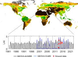
Long-term time series of global leaf area index (LAI) and fraction of absorbed photosynthetic active radiation (FAPAR) are required for characterizing vegetation dynamics in global change studies. The recently developed Copernicus Land Monitoring Service GEOV2-CLMS products were demonstrated to outperform other existing LAI and FAPAR products in terms of completeness, temporal smoothness, consistency across variables and accuracy. However, these GEOV2-CLMS products are derived from the SPOT/VGT and PROBA-V constellation with temporal coverage from 1999 to 2020 which limits its applicability for global change studies. We present here an adaptation of the GEOV2-CLMS algorithm to AVHRR to extend these time series and generate long-term global vegetation products from July 1981 to December 2022. The GEOV2-AVHRR algorithm was specifically designed to maximize the temporal consistency over the successive AVHRR sensors on board NOAA and MetOp-B satellites while keeping high agreement with GEOV2-CLMS products. Neural networks first transform AVHRR surface reflectance into LAI and FAPAR values at the daily time step. The daily estimates are then filtered, smoothed, gap filled and composited every 10-day.
GEOV2-AVHRR showed accuracy error between −0.2 and 0.3 LAI and ∼ −0.03 FAPAR and uncertainty <1 LAI and ∼ 0.10–0.15 for woody and non-woody sites of both DIRECT2.1 and GBOV V3 datasets. GEOV2-AVHRR agreed well with GEOV2-CLMS (MODIS): 92 % (76 %) of land pixels are within ±max(20 %, 0.5) LAI and 71 % (34 %) within ±max(10 %, 0.05) FAPAR uncertainty requirements. The gap filling and temporal filters applied in GEOV2-AVHRR proved effective in improving the completeness (only 1 % of missing data) and temporal precision (smoothness) of LAI and FAPAR time series as compared to MODIS. The intra-annual consistency of GEOV2-AVHRR highly agree with GEOV2-CLMS, indicating it is mostly driven by the algorithm. On the contrary, the inter-annual consistency of LAI and FAPAR datasets appears to be very sensitive to the consistency of the input surface reflectance. GEOV2-AVHRR showed high stability as evaluated with MODIS LAI/FAPAR and improves the stability of GEOV2-CLMS. Some residual inter-annual inconsistencies from the transition to sensors are observed for GEOV2-AVHRR as well as for other long term AVHRR datasets (i.e. GIMMS, GLASS and C3S). GEOV2-AVHRR shows overall greening trends in ∼70 % (∼50 % significant at p < 0.05) of land pixels, and the magnitude and spatial pattern of trends highly agree with those of GIMMS.
期刊介绍:
Remote Sensing of Environment (RSE) serves the Earth observation community by disseminating results on the theory, science, applications, and technology that contribute to advancing the field of remote sensing. With a thoroughly interdisciplinary approach, RSE encompasses terrestrial, oceanic, and atmospheric sensing.
The journal emphasizes biophysical and quantitative approaches to remote sensing at local to global scales, covering a diverse range of applications and techniques.
RSE serves as a vital platform for the exchange of knowledge and advancements in the dynamic field of remote sensing.