基于多模态遥感影像的滑坡实时监测轻量级双流关注网络
IF 4.5
Q2 ENVIRONMENTAL SCIENCES
Remote Sensing Applications-Society and Environment
Pub Date : 2025-09-19
DOI:10.1016/j.rsase.2025.101732
引用次数: 0
摘要
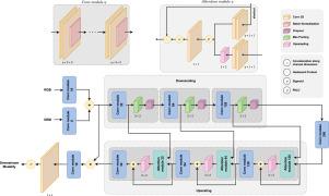
从事后遥感图像中快速描绘山体滑坡需要可以在现场部署的模型,通常是在具有严格内存和延迟预算的电池供电的边缘设备上。大多数最先进的探测器打破了这些限制,运送数千万个参数来获得边际精度。因此,我们引入了一个双流注意力网络,其可训练的总足迹仅为2.03 M个参数——大致相当于一张JPEG图像的大小——但仍然利用了共同注册的RGB正交图像和数字高程模型的互补物理特性。两个光编码器独立处理模态;一个可证明的等距后期融合算子在不丢失信息的情况下合并了它们的层次,一个(≤1)-Lipschitz空间通道门在保持梯度稳定性的同时丢弃了冗余特征。尽管其规模庞大,但该网络在高分辨率Bijie基准上的IoU为0.835,mIoU为0.818,与DeepLabv3\protect \relax \special {t4ht=+}(R-101)等重量级基准相比,使用的权重减少了约95%,在4-5个百分点之内。消融研究表明,每一种架构选择——双流处理、后期融合和注意门控——至少贡献1.5 pp IoU。一台Jetson Xavier AGX在1.6 s (<;10 W包线)内分割256 × 256瓦片,确认了快速滑坡测绘任务的实时适用性。通过协调dem衍生的信息和极高的参数效率,所提出的架构为下一代设备上的地质灾害监测系统提供了实用基础。本文章由计算机程序翻译,如有差异,请以英文原文为准。
A lightweight Dual-Stream Attention Network for real-time landslide monitoring in multi-modal remote sensing imagery
Rapid delineation of landslides from post-event remote-sensing imagery demands models that can be deployed in the field, often on battery-powered edge devices with strict memory and latency budgets. Most state-of-the-art detectors break those constraints, shipping tens of millions of parameters to gain marginal accuracy. We therefore introduce a Dual-Stream Attention Network whose total trainable footprint is just 2.03 M parameters – roughly the size of a single JPEG image – yet still exploits the complementary physics of co-registered RGB orthomosaics and digital-elevation models. Two light encoders process the modalities independently; a provably isometric late-fusion operator merges their hierarchies without information loss, and a -Lipschitz spatial-channel gate discards redundant features while preserving gradient stability. Despite its size, the network attains an IoU of 0.835 and an mIoU of 0.818 on the high-resolution Bijie benchmark, coming within 4–5 percentage points of heavyweight baselines such as DeepLabv3\protect \relax \special {t4ht=+}(R-101) while using fewer weights. Ablation studies show that each architectural choice – dual-stream processing, late fusion, and attentional gating – contributes at least pp IoU. A single Jetson Xavier AGX segments a 256 × 256 tile in 1.6 s ( W envelope), confirming real-time suitability for rapid landslide mapping missions. By reconciling DEM-derived information with extreme parameter efficiency, the proposed architecture offers a practical foundation for next-generation, on-device geohazard monitoring systems.
求助全文
通过发布文献求助,成功后即可免费获取论文全文。
去求助
来源期刊

CiteScore
8.00
自引率
8.50%
发文量
204
审稿时长
65 days
期刊介绍:
The journal ''Remote Sensing Applications: Society and Environment'' (RSASE) focuses on remote sensing studies that address specific topics with an emphasis on environmental and societal issues - regional / local studies with global significance. Subjects are encouraged to have an interdisciplinary approach and include, but are not limited by: " -Global and climate change studies addressing the impact of increasing concentrations of greenhouse gases, CO2 emission, carbon balance and carbon mitigation, energy system on social and environmental systems -Ecological and environmental issues including biodiversity, ecosystem dynamics, land degradation, atmospheric and water pollution, urban footprint, ecosystem management and natural hazards (e.g. earthquakes, typhoons, floods, landslides) -Natural resource studies including land-use in general, biomass estimation, forests, agricultural land, plantation, soils, coral reefs, wetland and water resources -Agriculture, food production systems and food security outcomes -Socio-economic issues including urban systems, urban growth, public health, epidemics, land-use transition and land use conflicts -Oceanography and coastal zone studies, including sea level rise projections, coastlines changes and the ocean-land interface -Regional challenges for remote sensing application techniques, monitoring and analysis, such as cloud screening and atmospheric correction for tropical regions -Interdisciplinary studies combining remote sensing, household survey data, field measurements and models to address environmental, societal and sustainability issues -Quantitative and qualitative analysis that documents the impact of using remote sensing studies in social, political, environmental or economic systems
 求助内容:
求助内容: 应助结果提醒方式:


