利用遥感和国家森林清查数据测绘瑞典的柴草
IF 8.6
Q1 REMOTE SENSING
International journal of applied earth observation and geoinformation : ITC journal
Pub Date : 2025-09-18
DOI:10.1016/j.jag.2025.104850
引用次数: 0
摘要
Cervid的浏览影响着全世界的森林生态系统,强调了在准确估计可用饲料的基础上进行野生动物管理的必要性。在这项研究中,我们通过结合国家森林清查(NFI)和不同遥感(RS)数据集的数据,为瑞典开发了第一个国家尺度的模型来估计cervid牧草的丰度。我们重点研究了瑞典六种主要的饲草树种:苏格兰松(Pinus sylvestris)、桦树(Betula spp.)、欧洲白杨(Populus tremula)、罗文(Sorbus aucuparia)、橡树(Quercus spp.)和山羊柳(Salix caprea)。本文章由计算机程序翻译,如有差异,请以英文原文为准。
Mapping cervid forage in Sweden using remote sensing and national forest inventory data
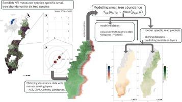
Cervid browsing influences forest ecosystems worldwide, stressing the need for wildlife management founded in accurate estimates of available forage. In this study, we developed the first national-scale models for Sweden to estimate the abundance of cervid forage by combining data from the National Forest Inventory (NFI) and different remote sensing (RS) datasets. We focused on six key forage tree species for cervids in Sweden: Scots pine (Pinus sylvestris), birch (Betula spp.), European aspen (Populus tremula), rowan (Sorbus aucuparia), oak (Quercus spp.), and goat willow (Salix caprea).
We combined airborne laser scanning and other auxiliary RS data with NFI data from 2016 to 2022 to model small tree abundance from 19 461 plots across Sweden in an area-based approach. We fitted generalized linear mixed models using likelihood-ratio tests to predict species-specific forage availability. Models were validated using an independent dataset of NFI data collected in 2023. Our models demonstrated moderate to strong predictive performance, with marginal R2 values ranging from 0.226 to 0.973. Model validation suggested higher RMSE and rRMSE values for tree species that are scarce throughout the country than for more abundant species.
We provide maps for all six modelled tree species, both at a 1 ha and a 1 km2 spatial scale, with the aim for them to be used in wildlife management, forestry planning, and ecological research. Our map products can for example help stakeholders assess a region’s spatial distribution of cervid forage and thus inform habitat management and potentially mitigate browsing-related economic losses in forestry.
求助全文
通过发布文献求助,成功后即可免费获取论文全文。
去求助
来源期刊

International journal of applied earth observation and geoinformation : ITC journal
Global and Planetary Change, Management, Monitoring, Policy and Law, Earth-Surface Processes, Computers in Earth Sciences
CiteScore
12.00
自引率
0.00%
发文量
0
审稿时长
77 days
期刊介绍:
The International Journal of Applied Earth Observation and Geoinformation publishes original papers that utilize earth observation data for natural resource and environmental inventory and management. These data primarily originate from remote sensing platforms, including satellites and aircraft, supplemented by surface and subsurface measurements. Addressing natural resources such as forests, agricultural land, soils, and water, as well as environmental concerns like biodiversity, land degradation, and hazards, the journal explores conceptual and data-driven approaches. It covers geoinformation themes like capturing, databasing, visualization, interpretation, data quality, and spatial uncertainty.
 求助内容:
求助内容: 应助结果提醒方式:


