{"title":"生态系统健康挑战:基于最大熵模型的库哈瓦-唐湖禁猎区摩富龙生境质量及其对物种生存状况的影响","authors":"Mohammadali Salmanpour, Hossein Parvaresh, Saber Ghasemi, Shadi Khatami","doi":"10.1007/s10661-025-14574-6","DOIUrl":null,"url":null,"abstract":"<div><p> The health of natural ecosystems is an important indicator for assessing the health of both the environment and human. The present descriptive-analytical study aimed to model habitat quality and its impact on the survival status of the Laristan mouflon (<i>Ovis orientalis laristanica</i>) species in the Hunting prohibition area of Kuh Hava-Tang Khor, using the maximum entropy model in 2022. The presence of this species was recorded at 87 locations using GPS. Four groups of environmental variables were identified as influential in determining habitat suitability: climatic factors (temperature, humidity, precipitation), vegetation cover (density), topographical factors (elevation, slope rate, and slope direction), and human factors (distance from water sources and roads). Bioclimatic variables were generated using R software, and bioclimatic maps were produced through the inverse distance weighting (IDW) method in ArcGIS 10.3. Vegetation density was calculated using the normalized difference vegetation index (NDVI). The ROC index was used to validate the model results. The results showed that the NDVI value for areas with vegetation was 0.3851, while for areas without vegetation, it was −0.4783. Slope classes ranging from 0 to 5.2 degrees and elevations between 448 and 596 m covered the largest area. The ROC value of 0.84 indicates a high accuracy of the model in estimating the presence points of the target species. Vegetation cover and distance from water sources were identified as the most significant components in the species’ distribution, accounting for 17.08% and 13.84% of the absolute effects, respectively. The Jackknife diagram revealed that vegetation cover, slope, and distance from water sources contributed 65%, 57%, and 48% of the total variance, respectively, playing a primary role in predicting habitat suitability. Overall, the results of this study demonstrate the potential of the maximum entropy model in analyzing habitat quality and its impact on the survival status of Laristan mouflon in the hunting prohibition area of Kuh Hava-Tang Khor.</p></div>","PeriodicalId":544,"journal":{"name":"Environmental Monitoring and Assessment","volume":"197 10","pages":""},"PeriodicalIF":3.0000,"publicationDate":"2025-09-16","publicationTypes":"Journal Article","fieldsOfStudy":null,"isOpenAccess":false,"openAccessPdf":"","citationCount":"0","resultStr":"{\"title\":\"Ecosystem health challenges: modeling the quality of the habitat and its effect on the survival status of Laristan mouflon (Ovis orientalis laristanica) species in the hunting prohibition area of Kuh Hava-Tang Khor based on the maximum entropy model\",\"authors\":\"Mohammadali Salmanpour, Hossein Parvaresh, Saber Ghasemi, Shadi Khatami\",\"doi\":\"10.1007/s10661-025-14574-6\",\"DOIUrl\":null,\"url\":null,\"abstract\":\"<div><p> The health of natural ecosystems is an important indicator for assessing the health of both the environment and human. The present descriptive-analytical study aimed to model habitat quality and its impact on the survival status of the Laristan mouflon (<i>Ovis orientalis laristanica</i>) species in the Hunting prohibition area of Kuh Hava-Tang Khor, using the maximum entropy model in 2022. The presence of this species was recorded at 87 locations using GPS. Four groups of environmental variables were identified as influential in determining habitat suitability: climatic factors (temperature, humidity, precipitation), vegetation cover (density), topographical factors (elevation, slope rate, and slope direction), and human factors (distance from water sources and roads). Bioclimatic variables were generated using R software, and bioclimatic maps were produced through the inverse distance weighting (IDW) method in ArcGIS 10.3. Vegetation density was calculated using the normalized difference vegetation index (NDVI). The ROC index was used to validate the model results. The results showed that the NDVI value for areas with vegetation was 0.3851, while for areas without vegetation, it was −0.4783. Slope classes ranging from 0 to 5.2 degrees and elevations between 448 and 596 m covered the largest area. The ROC value of 0.84 indicates a high accuracy of the model in estimating the presence points of the target species. Vegetation cover and distance from water sources were identified as the most significant components in the species’ distribution, accounting for 17.08% and 13.84% of the absolute effects, respectively. The Jackknife diagram revealed that vegetation cover, slope, and distance from water sources contributed 65%, 57%, and 48% of the total variance, respectively, playing a primary role in predicting habitat suitability. Overall, the results of this study demonstrate the potential of the maximum entropy model in analyzing habitat quality and its impact on the survival status of Laristan mouflon in the hunting prohibition area of Kuh Hava-Tang Khor.</p></div>\",\"PeriodicalId\":544,\"journal\":{\"name\":\"Environmental Monitoring and Assessment\",\"volume\":\"197 10\",\"pages\":\"\"},\"PeriodicalIF\":3.0000,\"publicationDate\":\"2025-09-16\",\"publicationTypes\":\"Journal Article\",\"fieldsOfStudy\":null,\"isOpenAccess\":false,\"openAccessPdf\":\"\",\"citationCount\":\"0\",\"resultStr\":null,\"platform\":\"Semanticscholar\",\"paperid\":null,\"PeriodicalName\":\"Environmental Monitoring and Assessment\",\"FirstCategoryId\":\"93\",\"ListUrlMain\":\"https://link.springer.com/article/10.1007/s10661-025-14574-6\",\"RegionNum\":4,\"RegionCategory\":\"环境科学与生态学\",\"ArticlePicture\":[],\"TitleCN\":null,\"AbstractTextCN\":null,\"PMCID\":null,\"EPubDate\":\"\",\"PubModel\":\"\",\"JCR\":\"Q3\",\"JCRName\":\"ENVIRONMENTAL SCIENCES\",\"Score\":null,\"Total\":0}","platform":"Semanticscholar","paperid":null,"PeriodicalName":"Environmental Monitoring and Assessment","FirstCategoryId":"93","ListUrlMain":"https://link.springer.com/article/10.1007/s10661-025-14574-6","RegionNum":4,"RegionCategory":"环境科学与生态学","ArticlePicture":[],"TitleCN":null,"AbstractTextCN":null,"PMCID":null,"EPubDate":"","PubModel":"","JCR":"Q3","JCRName":"ENVIRONMENTAL SCIENCES","Score":null,"Total":0}
引用次数: 0
摘要
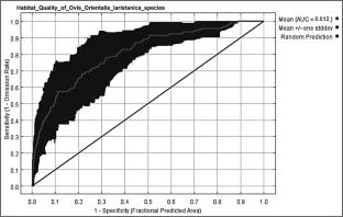
自然生态系统的健康状况是评价环境和人类健康状况的重要指标。本文采用2022年最大熵模型,对库哈瓦-唐湖禁猎区旱茅(Ovis orientalis laristica)生境质量及其对生存状况的影响进行了描述分析。利用GPS在87个地点记录了该物种的存在。确定了四组影响生境适宜性的环境变量:气候因素(温度、湿度、降水)、植被覆盖(密度)、地形因素(海拔、坡度和坡度方向)和人为因素(距离水源和道路的距离)。利用R软件生成生物气候变量,并在ArcGIS 10.3中通过逆距离加权(IDW)法生成生物气候图。植被密度采用归一化植被指数(NDVI)计算。采用ROC指数对模型结果进行验证。结果表明:有植被区NDVI值为0.3851,无植被区NDVI值为- 0.4783;坡度等级从0到5.2度,海拔高度在448到596米之间,覆盖了最大的面积。ROC值为0.84,表明模型对目标物种存在点的估计精度较高。植被覆盖度和水源距离对物种分布影响最大,分别占绝对影响的17.08%和13.84%。叠刀图显示,植被覆盖度、坡度和水源距离分别占总方差的65%、57%和48%,在预测生境适宜性中起主要作用。综上所述,本研究结果证明了最大熵模型在分析库哈瓦-唐湖禁猎区栖息地质量及其对泥鳅生存状况影响方面的潜力。
Ecosystem health challenges: modeling the quality of the habitat and its effect on the survival status of Laristan mouflon (Ovis orientalis laristanica) species in the hunting prohibition area of Kuh Hava-Tang Khor based on the maximum entropy model
The health of natural ecosystems is an important indicator for assessing the health of both the environment and human. The present descriptive-analytical study aimed to model habitat quality and its impact on the survival status of the Laristan mouflon (Ovis orientalis laristanica) species in the Hunting prohibition area of Kuh Hava-Tang Khor, using the maximum entropy model in 2022. The presence of this species was recorded at 87 locations using GPS. Four groups of environmental variables were identified as influential in determining habitat suitability: climatic factors (temperature, humidity, precipitation), vegetation cover (density), topographical factors (elevation, slope rate, and slope direction), and human factors (distance from water sources and roads). Bioclimatic variables were generated using R software, and bioclimatic maps were produced through the inverse distance weighting (IDW) method in ArcGIS 10.3. Vegetation density was calculated using the normalized difference vegetation index (NDVI). The ROC index was used to validate the model results. The results showed that the NDVI value for areas with vegetation was 0.3851, while for areas without vegetation, it was −0.4783. Slope classes ranging from 0 to 5.2 degrees and elevations between 448 and 596 m covered the largest area. The ROC value of 0.84 indicates a high accuracy of the model in estimating the presence points of the target species. Vegetation cover and distance from water sources were identified as the most significant components in the species’ distribution, accounting for 17.08% and 13.84% of the absolute effects, respectively. The Jackknife diagram revealed that vegetation cover, slope, and distance from water sources contributed 65%, 57%, and 48% of the total variance, respectively, playing a primary role in predicting habitat suitability. Overall, the results of this study demonstrate the potential of the maximum entropy model in analyzing habitat quality and its impact on the survival status of Laristan mouflon in the hunting prohibition area of Kuh Hava-Tang Khor.
期刊介绍:
Environmental Monitoring and Assessment emphasizes technical developments and data arising from environmental monitoring and assessment, the use of scientific principles in the design of monitoring systems at the local, regional and global scales, and the use of monitoring data in assessing the consequences of natural resource management actions and pollution risks to man and the environment.

 求助内容:
求助内容: 应助结果提醒方式:


