基于多源遥感数据的泥石流灾害预测——以云南省独龙江镇为例
IF 4.5
Q2 ENVIRONMENTAL SCIENCES
Remote Sensing Applications-Society and Environment
Pub Date : 2025-08-01
DOI:10.1016/j.rsase.2025.101719
引用次数: 0
摘要
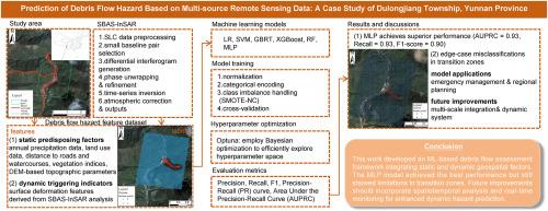
泥石流是一种具有突发性和广泛影响区域的高破坏性自然灾害,对世界各地的山区,特别是中国云南省等地质脆弱地区构成严重威胁。这些事件的准确预测对于防灾和减灾至关重要,但由于环境因素的复杂相互作用,这仍然具有挑战性。结合多源遥感数据和机器学习技术,提出了云南省独龙江乡泥石流预测的先进框架。通过结合光学、合成孔径雷达(SAR)和地形数据集,我们开发了一种基于网格的高分辨率方法,可以捕获静态诱发因素和动态前兆信号。在6个被评估的ML模型中,多层感知器(MLP)表现出较好的性能,在泥石流预测中实现了精确召回曲线下面积(AUPRC)得分为0.94,召回率和精度分别为0.93和0.86。与传统的静态因子模型相比,基于小基线子集干涉合成孔径雷达(SBAS-InSAR)的地表变形预测精度显著提高,为改进山区预警系统建立了一种新的方法。这项研究为灾害预防提供了有价值的见解,可以适用于全球其他地质灾害易发地区。本文章由计算机程序翻译,如有差异,请以英文原文为准。
Prediction of debris flow hazard based on multi-source remote sensing data: A case study of Dulongjiang Township, Yunnan Province
Debris flows, characterized as a highly destructive natural hazard with sudden onset and extensive impact zones, pose severe threats to mountainous regions worldwide, particularly in geologically vulnerable areas like China's Yunnan Province. Accurate prediction of these events is crucial for disaster prevention and mitigation, yet it remains challenging due to the complex interplay of environmental factors. This investigation presents an advanced debris flow prediction framework for Dulongjiang Township in Yunnan Province by integrating multi-source remote sensing data and machine learning (ML) techniques. By combining optical, Synthetic Aperture Radar (SAR), and topographic datasets, we develop a high-resolution grid-based approach that captures both static predisposing factors and dynamic precursory signals. Among six evaluated ML models, the Multilayer Perceptron (MLP) demonstrated superior performance, achieving an Area Under the Precision-Recall Curve (AUPRC) score of 0.94, with recall and precision of 0.93 and 0.86, respectively, in debris flow prediction. The incorporation of Small Baseline Subset Interferometric Synthetic Aperture Radar (SBAS-InSAR)-based surface deformation significantly enhanced prediction accuracy compared to traditional static-factor models, establishing a novel methodology for improved early warning systems in mountainous regions. This research provides valuable insights for disaster prevention and could be adapted to other geohazard-prone areas worldwide.
求助全文
通过发布文献求助,成功后即可免费获取论文全文。
去求助
来源期刊

CiteScore
8.00
自引率
8.50%
发文量
204
审稿时长
65 days
期刊介绍:
The journal ''Remote Sensing Applications: Society and Environment'' (RSASE) focuses on remote sensing studies that address specific topics with an emphasis on environmental and societal issues - regional / local studies with global significance. Subjects are encouraged to have an interdisciplinary approach and include, but are not limited by: " -Global and climate change studies addressing the impact of increasing concentrations of greenhouse gases, CO2 emission, carbon balance and carbon mitigation, energy system on social and environmental systems -Ecological and environmental issues including biodiversity, ecosystem dynamics, land degradation, atmospheric and water pollution, urban footprint, ecosystem management and natural hazards (e.g. earthquakes, typhoons, floods, landslides) -Natural resource studies including land-use in general, biomass estimation, forests, agricultural land, plantation, soils, coral reefs, wetland and water resources -Agriculture, food production systems and food security outcomes -Socio-economic issues including urban systems, urban growth, public health, epidemics, land-use transition and land use conflicts -Oceanography and coastal zone studies, including sea level rise projections, coastlines changes and the ocean-land interface -Regional challenges for remote sensing application techniques, monitoring and analysis, such as cloud screening and atmospheric correction for tropical regions -Interdisciplinary studies combining remote sensing, household survey data, field measurements and models to address environmental, societal and sustainability issues -Quantitative and qualitative analysis that documents the impact of using remote sensing studies in social, political, environmental or economic systems
 求助内容:
求助内容: 应助结果提醒方式:


