海岛森林景观中与保护状况和道路基础设施相关的碳储量地理空间格局
IF 4.5
Q2 ENVIRONMENTAL SCIENCES
Remote Sensing Applications-Society and Environment
Pub Date : 2025-08-01
DOI:10.1016/j.rsase.2025.101713
引用次数: 0
摘要
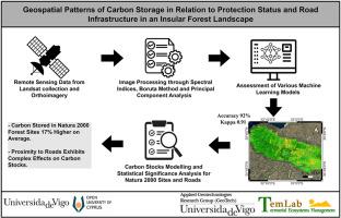
森林通过碳储存在减缓气候变化方面发挥着至关重要的作用。然而,这些生态系统面临着越来越多的人类活动的威胁,如基础设施发展和土地利用/土地覆盖(LULC)的变化。迄今为止,有限的研究集中在了解道路如何影响森林中的碳储量,以及这种关系如何受到保护制度的影响,特别是在岛屿上。在塞浦路塞岛上进行的这项研究旨在评估用于估计林冠覆盖(CC)等关键森林变量的机器学习(ML)技术,并分析与lulc和保护制度相关的道路周围碳储量的空间动态。遥感(RS)数据,包括陆地卫星图像和正射影像,与ML相结合,创建了一个详细的LULC分类的集成模型。利用生态系统服务与权衡综合评估(InVEST)工具估算每个LULC的碳储量,并利用统计分析评估森林、道路和保护制度之间的相互作用。分析显示,受保护的地点比未受保护的地区多储存17%的碳,而靠近道路对碳储量表现出复杂的影响,其模式因保护状况而异。集成模型优于单个模型,达到92%的准确率和0.91的kappa,显示了组合算法的优势,可以进行更稳健的预测。该研究强调了将机器学习与生态系统服务模型相结合的影响,以提高对道路、LULC和森林之间相互作用的理解。它还强调了保护和路边植被管理对生态系统恢复力和可持续碳储存的重要性。本文章由计算机程序翻译,如有差异,请以英文原文为准。
Geospatial patterns of carbon storage in relation to protection status and road infrastructure in an insular forest landscape
Forests play a crucial role in climate change mitigation through carbon storage. Nevertheless, these ecosystems face increasing threats from human activities, such as infrastructure development and Land Use/Land Cover (LULC) changes. To date, limited research has focused on understanding how roads impact carbon stocks in forests, and how this relation is influenced by protection regimes, especially on islands. This study on the island of Cyprus aims to assess Machine Learning (ML) techniques for estimating key forest variables such as Canopy Cover (CC) and to analyze the spatial dynamics of carbon stocks around roads in relation to LULCs and protection regimes. Remote Sensing (RS) data, including Landsat imagery and orthophotos, are combined with ML to create an ensemble model for detailed LULC classifications. The Integrated Valuation of Ecosystem Services and Trade-offs (InVEST) tool is utilized to estimate carbon stocks for each LULC and statistical analysis is used to evaluate interactions between forests, roads, and protection regimes. The analysis revealed that protected sites store significantly 17 % more carbon than unprotected areas whilst proximity to roads exhibits complex effects on carbon stocks, with varying patterns depending on the protection status. The ensemble model outperforms individual models, achieving 92 % accuracy and a kappa of 0.91, showing the advantages of combining algorithms for more robust predictions. The research highlights the impact of integrating ML with ecosystem service models to improve understanding of interactions between roads, LULC, and forests. It also emphasizes the importance of conservation and roadside vegetation management for ecosystem resilience and sustainable carbon storage.
求助全文
通过发布文献求助,成功后即可免费获取论文全文。
去求助
来源期刊

CiteScore
8.00
自引率
8.50%
发文量
204
审稿时长
65 days
期刊介绍:
The journal ''Remote Sensing Applications: Society and Environment'' (RSASE) focuses on remote sensing studies that address specific topics with an emphasis on environmental and societal issues - regional / local studies with global significance. Subjects are encouraged to have an interdisciplinary approach and include, but are not limited by: " -Global and climate change studies addressing the impact of increasing concentrations of greenhouse gases, CO2 emission, carbon balance and carbon mitigation, energy system on social and environmental systems -Ecological and environmental issues including biodiversity, ecosystem dynamics, land degradation, atmospheric and water pollution, urban footprint, ecosystem management and natural hazards (e.g. earthquakes, typhoons, floods, landslides) -Natural resource studies including land-use in general, biomass estimation, forests, agricultural land, plantation, soils, coral reefs, wetland and water resources -Agriculture, food production systems and food security outcomes -Socio-economic issues including urban systems, urban growth, public health, epidemics, land-use transition and land use conflicts -Oceanography and coastal zone studies, including sea level rise projections, coastlines changes and the ocean-land interface -Regional challenges for remote sensing application techniques, monitoring and analysis, such as cloud screening and atmospheric correction for tropical regions -Interdisciplinary studies combining remote sensing, household survey data, field measurements and models to address environmental, societal and sustainability issues -Quantitative and qualitative analysis that documents the impact of using remote sensing studies in social, political, environmental or economic systems
 求助内容:
求助内容: 应助结果提醒方式:


