Stephen Biliyitorb Liwur , Jacob Nchagmado Tagnan , Pearl Seyram Asamoah
{"title":"城市增长还是城市风险?通过自然因素和空间决策模型的视角揭示库马西(加纳)的洪水悖论","authors":"Stephen Biliyitorb Liwur , Jacob Nchagmado Tagnan , Pearl Seyram Asamoah","doi":"10.1016/j.jafrearsci.2025.105814","DOIUrl":null,"url":null,"abstract":"<div><div>Amid accelerating urbanization across the global landscape, urban sustainability finds itself in a precarious balance, particularly in the face of increasing flood risks. As such, this study aims to assess and map flood risk in Kumasi. Methodologically, this study is grounded in the analytical hierarchy process (AHP) spatial decision modelling approach to unearth the varied impacts of natural and urban factors on flood susceptibility in the city. Consequently, the resulting model reveals that approximately 98 % of the city is moderately to highly susceptible to flooding. This model result is supported by a validation assessment with an overall accuracy of 95 % and a Kappa coefficient of 0.91, emphasizing the urgency for actionable flood management and resilient urban planning. The model also points out that natural terrain variables including elevation (β = 0.1324, p < 0.001), slope (β = 0.0707, p < 0.001), topographic wetness index (β = 0.1062, p < 0.001), drainage density, and proximity to rivers and urban development dynamics (Normalized Difference Vegetation Index: β = 0.0402, p < 0.001, and Land use and land cover: β = 0.0201, p < 0.046) are major predictors of flood susceptibility. Consequently, this study calls for a paradigm shift toward spatially integrated urban governance, anchored in proactive spatial planning, informed land use policies, and hydrologically responsive infrastructure design for the city.</div></div>","PeriodicalId":14874,"journal":{"name":"Journal of African Earth Sciences","volume":"232 ","pages":"Article 105814"},"PeriodicalIF":2.2000,"publicationDate":"2025-08-12","publicationTypes":"Journal Article","fieldsOfStudy":null,"isOpenAccess":false,"openAccessPdf":"","citationCount":"0","resultStr":"{\"title\":\"Urban growth or urban risk? Unraveling the flood paradox in Kumasi (Ghana) through the lens of natural factors and spatial decision modeling\",\"authors\":\"Stephen Biliyitorb Liwur , Jacob Nchagmado Tagnan , Pearl Seyram Asamoah\",\"doi\":\"10.1016/j.jafrearsci.2025.105814\",\"DOIUrl\":null,\"url\":null,\"abstract\":\"<div><div>Amid accelerating urbanization across the global landscape, urban sustainability finds itself in a precarious balance, particularly in the face of increasing flood risks. As such, this study aims to assess and map flood risk in Kumasi. Methodologically, this study is grounded in the analytical hierarchy process (AHP) spatial decision modelling approach to unearth the varied impacts of natural and urban factors on flood susceptibility in the city. Consequently, the resulting model reveals that approximately 98 % of the city is moderately to highly susceptible to flooding. This model result is supported by a validation assessment with an overall accuracy of 95 % and a Kappa coefficient of 0.91, emphasizing the urgency for actionable flood management and resilient urban planning. The model also points out that natural terrain variables including elevation (β = 0.1324, p < 0.001), slope (β = 0.0707, p < 0.001), topographic wetness index (β = 0.1062, p < 0.001), drainage density, and proximity to rivers and urban development dynamics (Normalized Difference Vegetation Index: β = 0.0402, p < 0.001, and Land use and land cover: β = 0.0201, p < 0.046) are major predictors of flood susceptibility. Consequently, this study calls for a paradigm shift toward spatially integrated urban governance, anchored in proactive spatial planning, informed land use policies, and hydrologically responsive infrastructure design for the city.</div></div>\",\"PeriodicalId\":14874,\"journal\":{\"name\":\"Journal of African Earth Sciences\",\"volume\":\"232 \",\"pages\":\"Article 105814\"},\"PeriodicalIF\":2.2000,\"publicationDate\":\"2025-08-12\",\"publicationTypes\":\"Journal Article\",\"fieldsOfStudy\":null,\"isOpenAccess\":false,\"openAccessPdf\":\"\",\"citationCount\":\"0\",\"resultStr\":null,\"platform\":\"Semanticscholar\",\"paperid\":null,\"PeriodicalName\":\"Journal of African Earth Sciences\",\"FirstCategoryId\":\"89\",\"ListUrlMain\":\"https://www.sciencedirect.com/science/article/pii/S1464343X2500281X\",\"RegionNum\":4,\"RegionCategory\":\"地球科学\",\"ArticlePicture\":[],\"TitleCN\":null,\"AbstractTextCN\":null,\"PMCID\":null,\"EPubDate\":\"\",\"PubModel\":\"\",\"JCR\":\"Q2\",\"JCRName\":\"GEOSCIENCES, MULTIDISCIPLINARY\",\"Score\":null,\"Total\":0}","platform":"Semanticscholar","paperid":null,"PeriodicalName":"Journal of African Earth Sciences","FirstCategoryId":"89","ListUrlMain":"https://www.sciencedirect.com/science/article/pii/S1464343X2500281X","RegionNum":4,"RegionCategory":"地球科学","ArticlePicture":[],"TitleCN":null,"AbstractTextCN":null,"PMCID":null,"EPubDate":"","PubModel":"","JCR":"Q2","JCRName":"GEOSCIENCES, MULTIDISCIPLINARY","Score":null,"Total":0}
引用次数: 0
摘要
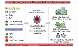
在全球城市化加速的背景下,城市可持续性发现自己处于不稳定的平衡状态,尤其是在洪水风险日益增加的情况下。因此,本研究的目的是评估和绘制库马西的洪水风险。在方法上,本研究基于层次分析法(AHP)空间决策建模方法,揭示自然因素和城市因素对城市洪水易感性的不同影响。因此,由此得出的模型显示,大约98%的城市是中等到高度易受洪水影响的。该模型结果得到了总体精度为95%、Kappa系数为0.91的验证评估的支持,强调了可操作性洪水管理和弹性城市规划的紧迫性。该模型还指出,高程(β = 0.1324, p < 0.001)、坡度(β = 0.0707, p < 0.001)、地形湿度指数(β = 0.1062, p < 0.001)、排水密度、靠近河流和城市发展动态(归一化植被指数:β = 0.0402, p < 0.001,土地利用和土地覆盖:β = 0.0201, p < 0.046)等自然地形变量是洪水易感性的主要预测因子。因此,本研究呼吁向空间一体化城市治理模式转变,以积极的空间规划、明智的土地使用政策和水文响应型城市基础设施设计为基础。
Urban growth or urban risk? Unraveling the flood paradox in Kumasi (Ghana) through the lens of natural factors and spatial decision modeling
Amid accelerating urbanization across the global landscape, urban sustainability finds itself in a precarious balance, particularly in the face of increasing flood risks. As such, this study aims to assess and map flood risk in Kumasi. Methodologically, this study is grounded in the analytical hierarchy process (AHP) spatial decision modelling approach to unearth the varied impacts of natural and urban factors on flood susceptibility in the city. Consequently, the resulting model reveals that approximately 98 % of the city is moderately to highly susceptible to flooding. This model result is supported by a validation assessment with an overall accuracy of 95 % and a Kappa coefficient of 0.91, emphasizing the urgency for actionable flood management and resilient urban planning. The model also points out that natural terrain variables including elevation (β = 0.1324, p < 0.001), slope (β = 0.0707, p < 0.001), topographic wetness index (β = 0.1062, p < 0.001), drainage density, and proximity to rivers and urban development dynamics (Normalized Difference Vegetation Index: β = 0.0402, p < 0.001, and Land use and land cover: β = 0.0201, p < 0.046) are major predictors of flood susceptibility. Consequently, this study calls for a paradigm shift toward spatially integrated urban governance, anchored in proactive spatial planning, informed land use policies, and hydrologically responsive infrastructure design for the city.
期刊介绍:
The Journal of African Earth Sciences sees itself as the prime geological journal for all aspects of the Earth Sciences about the African plate. Papers dealing with peripheral areas are welcome if they demonstrate a tight link with Africa.
The Journal publishes high quality, peer-reviewed scientific papers. It is devoted primarily to research papers but short communications relating to new developments of broad interest, reviews and book reviews will also be considered. Papers must have international appeal and should present work of more regional than local significance and dealing with well identified and justified scientific questions. Specialised technical papers, analytical or exploration reports must be avoided. Papers on applied geology should preferably be linked to such core disciplines and must be addressed to a more general geoscientific audience.