一种新颖的随机森林方法将SMAP土壤湿度产品降尺度到100米分辨率,使用时间最接近的卫星观测数据
IF 4.5
Q2 ENVIRONMENTAL SCIENCES
Remote Sensing Applications-Society and Environment
Pub Date : 2025-08-01
DOI:10.1016/j.rsase.2025.101710
引用次数: 0
摘要
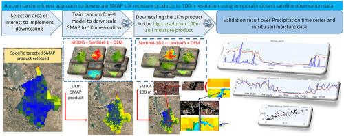
地表土壤湿度是控制水和能量收支以及其他水文和地表过程的重要因素。然而,监测土壤湿度的卫星数据的粗分辨率提出了一个问题,可以通过降尺度来解决。本文提出了一种基于Landsat、MODIS、Sentinel-1和Sentinel-2卫星数据的随机森林模型对粗分辨率土壤湿度主动式被动(SMAP)土壤湿度产品进行降尺度的新方法。关键变量包括植被指数、地表温度、低分辨率微波数据和海拔。利用谷歌地球引擎(GEE),为每个SMAP图像开发了单独的模型,使用最接近的精细卫星数据来解释时间变化并提高预测精度。在不同的时空尺度和土地覆盖类型上对缩小后的产品进行了评估,结果表明,该产品与降水和灌溉事件具有很强的相关性,在水体检测方面具有很高的效率,并且能够区分作物类型和水分条件。与西班牙REMEDHUS网络的土壤湿度时间序列比较,结果吻合良好,r值为0.697,RMSE为0.098 m3/m3,非常接近其更粗糙的分辨率对应的SMAP/Sentinel-1 1 km产品,RMSE为0.07 m3/m3,突出了缩小后产品的鲁棒性和准确性。为每个目标土壤湿度产品开发模型,而不是为所有图像开发单个模型,在保持预测准确性的同时减少了训练阶段的时间和体积。本研究的结果表明,将土壤水分数据降尺度到100 m分辨率显著提高了在更精细尺度上监测和管理土壤水分的能力。这一改进对精准农业、水文建模和环境监测具有广泛的影响,可能导致更好的资源管理、提高作物产量和更准确的水文预测。本文章由计算机程序翻译,如有差异,请以英文原文为准。
A novel random forest approach to downscale SMAP soil moisture products to 100 m resolution using temporally closest satellite observation data
Surface soil moisture is an important factor in controlling the water and energy budget, as well as other hydrological and land surface processes. However, the coarse resolution of satellite data monitoring soil moisture presents a problem that can be addressed by downscaling. This study presents a novel approach for downscaling the coarse-resolution Soil Moisture Active Passive (SMAP) soil moisture product using a random forest model with data from Landsat, MODIS, Sentinel-1, and Sentinel-2 satellites. Key variables include vegetation indices, land surface temperature (LST), low-resolution microwave data, and elevation. Leveraging Google Earth Engine (GEE), individual models are developed for each SMAP image, using the closest finer satellite data to account for temporal variations and enhance prediction accuracy. The downscaled product was evaluated across various spatiotemporal scales and land cover types, showing strong correlations with precipitation and irrigation events, high efficacy in water body detection, and differentiation between crop types and moisture conditions. Comparisons with soil moisture time series from Spain's REMEDHUS network indicate good agreement, with an R-value of 0.697 and an RMSE of 0.098 m3/m3, very close to its much coarser resolution counterpart SMAP/Sentinel-1 1 km product with RMSE 0.07 m3/m3, highlighting the downscaled product's robustness and accuracy. Developing the model for each target soil moisture product, as opposed to a single model for all images, reduces the time and volume of the training phase while maintaining prediction accuracy. This study's findings suggest that downscaling soil moisture data to 100 m resolution significantly enhances the ability to monitor and manage soil moisture at a finer scale. This improvement has broad implications for precision agriculture, hydrological modeling, and environmental monitoring, potentially leading to better resource management, improved crop yields, and more accurate hydrological predictions.
求助全文
通过发布文献求助,成功后即可免费获取论文全文。
去求助
来源期刊

CiteScore
8.00
自引率
8.50%
发文量
204
审稿时长
65 days
期刊介绍:
The journal ''Remote Sensing Applications: Society and Environment'' (RSASE) focuses on remote sensing studies that address specific topics with an emphasis on environmental and societal issues - regional / local studies with global significance. Subjects are encouraged to have an interdisciplinary approach and include, but are not limited by: " -Global and climate change studies addressing the impact of increasing concentrations of greenhouse gases, CO2 emission, carbon balance and carbon mitigation, energy system on social and environmental systems -Ecological and environmental issues including biodiversity, ecosystem dynamics, land degradation, atmospheric and water pollution, urban footprint, ecosystem management and natural hazards (e.g. earthquakes, typhoons, floods, landslides) -Natural resource studies including land-use in general, biomass estimation, forests, agricultural land, plantation, soils, coral reefs, wetland and water resources -Agriculture, food production systems and food security outcomes -Socio-economic issues including urban systems, urban growth, public health, epidemics, land-use transition and land use conflicts -Oceanography and coastal zone studies, including sea level rise projections, coastlines changes and the ocean-land interface -Regional challenges for remote sensing application techniques, monitoring and analysis, such as cloud screening and atmospheric correction for tropical regions -Interdisciplinary studies combining remote sensing, household survey data, field measurements and models to address environmental, societal and sustainability issues -Quantitative and qualitative analysis that documents the impact of using remote sensing studies in social, political, environmental or economic systems
 求助内容:
求助内容: 应助结果提醒方式:


