Federica Massimi, Antonio Tedeschi, Kalapraveen Bagadi, Francesco Benedetto
{"title":"整合谷歌地图和平滑街景视频的路线规划。","authors":"Federica Massimi, Antonio Tedeschi, Kalapraveen Bagadi, Francesco Benedetto","doi":"10.3390/jimaging11080251","DOIUrl":null,"url":null,"abstract":"<p><p>This research addresses the long-standing dependence on printed maps for navigation and highlights the limitations of existing digital services like Google Street View and Google Street View Player in providing comprehensive solutions for route analysis and understanding. The absence of a systematic approach to route analysis, issues related to insufficient street view images, and the lack of proper image mapping for desired roads remain unaddressed by current applications, which are predominantly client-based. In response, we propose an innovative automatic system designed to generate videos depicting road routes between two geographic locations. The system calculates and presents the route conventionally, emphasizing the path on a two-dimensional representation, and in a multimedia format. A prototype is developed based on a cloud-based client-server architecture, featuring three core modules: frames acquisition, frames analysis and elaboration, and the persistence of metadata information and computed videos. The tests, encompassing both real-world and synthetic scenarios, have produced promising results, showcasing the efficiency of our system. By providing users with a real and immersive understanding of requested routes, our approach fills a crucial gap in existing navigation solutions. This research contributes to the advancement of route planning technologies, offering a comprehensive and user-friendly system that leverages cloud computing and multimedia visualization for an enhanced navigation experience.</p>","PeriodicalId":37035,"journal":{"name":"Journal of Imaging","volume":"11 8","pages":""},"PeriodicalIF":2.7000,"publicationDate":"2025-07-25","publicationTypes":"Journal Article","fieldsOfStudy":null,"isOpenAccess":false,"openAccessPdf":"https://www.ncbi.nlm.nih.gov/pmc/articles/PMC12387516/pdf/","citationCount":"0","resultStr":"{\"title\":\"Integrating Google Maps and Smooth Street View Videos for Route Planning.\",\"authors\":\"Federica Massimi, Antonio Tedeschi, Kalapraveen Bagadi, Francesco Benedetto\",\"doi\":\"10.3390/jimaging11080251\",\"DOIUrl\":null,\"url\":null,\"abstract\":\"<p><p>This research addresses the long-standing dependence on printed maps for navigation and highlights the limitations of existing digital services like Google Street View and Google Street View Player in providing comprehensive solutions for route analysis and understanding. The absence of a systematic approach to route analysis, issues related to insufficient street view images, and the lack of proper image mapping for desired roads remain unaddressed by current applications, which are predominantly client-based. In response, we propose an innovative automatic system designed to generate videos depicting road routes between two geographic locations. The system calculates and presents the route conventionally, emphasizing the path on a two-dimensional representation, and in a multimedia format. A prototype is developed based on a cloud-based client-server architecture, featuring three core modules: frames acquisition, frames analysis and elaboration, and the persistence of metadata information and computed videos. The tests, encompassing both real-world and synthetic scenarios, have produced promising results, showcasing the efficiency of our system. By providing users with a real and immersive understanding of requested routes, our approach fills a crucial gap in existing navigation solutions. This research contributes to the advancement of route planning technologies, offering a comprehensive and user-friendly system that leverages cloud computing and multimedia visualization for an enhanced navigation experience.</p>\",\"PeriodicalId\":37035,\"journal\":{\"name\":\"Journal of Imaging\",\"volume\":\"11 8\",\"pages\":\"\"},\"PeriodicalIF\":2.7000,\"publicationDate\":\"2025-07-25\",\"publicationTypes\":\"Journal Article\",\"fieldsOfStudy\":null,\"isOpenAccess\":false,\"openAccessPdf\":\"https://www.ncbi.nlm.nih.gov/pmc/articles/PMC12387516/pdf/\",\"citationCount\":\"0\",\"resultStr\":null,\"platform\":\"Semanticscholar\",\"paperid\":null,\"PeriodicalName\":\"Journal of Imaging\",\"FirstCategoryId\":\"1085\",\"ListUrlMain\":\"https://doi.org/10.3390/jimaging11080251\",\"RegionNum\":0,\"RegionCategory\":null,\"ArticlePicture\":[],\"TitleCN\":null,\"AbstractTextCN\":null,\"PMCID\":null,\"EPubDate\":\"\",\"PubModel\":\"\",\"JCR\":\"Q3\",\"JCRName\":\"IMAGING SCIENCE & PHOTOGRAPHIC TECHNOLOGY\",\"Score\":null,\"Total\":0}","platform":"Semanticscholar","paperid":null,"PeriodicalName":"Journal of Imaging","FirstCategoryId":"1085","ListUrlMain":"https://doi.org/10.3390/jimaging11080251","RegionNum":0,"RegionCategory":null,"ArticlePicture":[],"TitleCN":null,"AbstractTextCN":null,"PMCID":null,"EPubDate":"","PubModel":"","JCR":"Q3","JCRName":"IMAGING SCIENCE & PHOTOGRAPHIC TECHNOLOGY","Score":null,"Total":0}
Integrating Google Maps and Smooth Street View Videos for Route Planning.
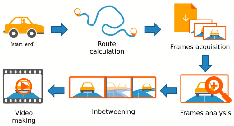
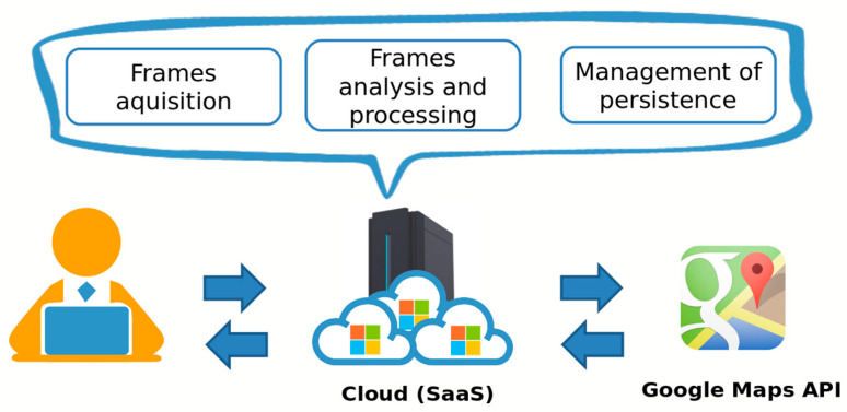
This research addresses the long-standing dependence on printed maps for navigation and highlights the limitations of existing digital services like Google Street View and Google Street View Player in providing comprehensive solutions for route analysis and understanding. The absence of a systematic approach to route analysis, issues related to insufficient street view images, and the lack of proper image mapping for desired roads remain unaddressed by current applications, which are predominantly client-based. In response, we propose an innovative automatic system designed to generate videos depicting road routes between two geographic locations. The system calculates and presents the route conventionally, emphasizing the path on a two-dimensional representation, and in a multimedia format. A prototype is developed based on a cloud-based client-server architecture, featuring three core modules: frames acquisition, frames analysis and elaboration, and the persistence of metadata information and computed videos. The tests, encompassing both real-world and synthetic scenarios, have produced promising results, showcasing the efficiency of our system. By providing users with a real and immersive understanding of requested routes, our approach fills a crucial gap in existing navigation solutions. This research contributes to the advancement of route planning technologies, offering a comprehensive and user-friendly system that leverages cloud computing and multimedia visualization for an enhanced navigation experience.

 求助内容:
求助内容: 应助结果提醒方式:


