{"title":"绘制森林细粒土壤粒度分布:通过图形神经网络、激光雷达和Sentinel-2的整体GeoAI方法","authors":"Omid Abdi, Ville Laamanen, Jori Uusitalo","doi":"10.1016/j.jag.2025.104807","DOIUrl":null,"url":null,"abstract":"<div><div>Fine-grained soils are crucial for assessing forest diversity and soil disturbances. Existing models for predicting particle size distributions (PSDs) often rely heavily on soil samples or lack necessary spatial dependencies, scalability and flexibility. This study introduces a holistic GeoAI model using graph neural networks (GNNs), LiDAR, and Sentinel-2 data to address these limitations. We collected 330 soil samples from 47 forest stands with a random-stratified method in southwestern Finland. The samples were pre-processed and analyzed for PSDs using a laser diffraction method, and classified into four groups: <2 µm, 2–6 µm, 6–20 µm, and 20–60 µm. To increase the number of annotations, we predicted soil PSDs at unmeasured locations using CoKriging within stands. The forests were segmented into small homogeneous polygons to construct the graph layer. We mapped 61 covariates using LiDAR and Sentinel-2 based on <em>scorpan</em> model, which were then summarized into the graph layer. Subsequently, we established the pipelines of five GNN models regarding the top covariates. The results indicate that geomorphometry and organisms covariates accounted for the majority of importance. The graph attention network (GAT) recorded high stability during training and remarkable prediction accuracy after testing with R<sup>2</sup> values above 0.98 in predicting fine-grained soil PSDs across all four soil groups. Conversely, the relational graph convolutional networks (RGCN) also achieved R<sup>2</sup> values above 0.97, but with lower stability and longer training times. However, the high accuracy of the predictive models is partly due to the large number of annotations derived from CoKriging, which may introduce uncertainties. Our GAT model demonstrated strong transferability when applied to an independent test stand using CoKriging-derived data (R<sup>2</sup>: 0.98–0.99) and showed robust performance when evaluated against real ground-truth samples (R<sup>2</sup>: 0.88–0.95). The observed prediction errors (RMSE: 0.68–2.82) reflect a combination of uncertainties originating from the CoKriging training data (RMSE: 0.34–2.46) and model-induced errors during training (RMSE: 0.37–1.46). Nevertheless, the consistently high R<sup>2</sup> values indicate a strong agreement between predicted and measured soil PSDs. Future studies should focus on training the model with a larger number of ground-truth soil samples and evaluating its transferability across diverse boreal forest landscapes.</div></div>","PeriodicalId":73423,"journal":{"name":"International journal of applied earth observation and geoinformation : ITC journal","volume":"143 ","pages":"Article 104807"},"PeriodicalIF":8.6000,"publicationDate":"2025-09-01","publicationTypes":"Journal Article","fieldsOfStudy":null,"isOpenAccess":false,"openAccessPdf":"","citationCount":"0","resultStr":"{\"title\":\"Mapping forest fine-grained soil particle size distributions: a holistic GeoAI approach via graph neural networks, LiDAR, and Sentinel-2\",\"authors\":\"Omid Abdi, Ville Laamanen, Jori Uusitalo\",\"doi\":\"10.1016/j.jag.2025.104807\",\"DOIUrl\":null,\"url\":null,\"abstract\":\"<div><div>Fine-grained soils are crucial for assessing forest diversity and soil disturbances. Existing models for predicting particle size distributions (PSDs) often rely heavily on soil samples or lack necessary spatial dependencies, scalability and flexibility. This study introduces a holistic GeoAI model using graph neural networks (GNNs), LiDAR, and Sentinel-2 data to address these limitations. We collected 330 soil samples from 47 forest stands with a random-stratified method in southwestern Finland. The samples were pre-processed and analyzed for PSDs using a laser diffraction method, and classified into four groups: <2 µm, 2–6 µm, 6–20 µm, and 20–60 µm. To increase the number of annotations, we predicted soil PSDs at unmeasured locations using CoKriging within stands. The forests were segmented into small homogeneous polygons to construct the graph layer. We mapped 61 covariates using LiDAR and Sentinel-2 based on <em>scorpan</em> model, which were then summarized into the graph layer. Subsequently, we established the pipelines of five GNN models regarding the top covariates. The results indicate that geomorphometry and organisms covariates accounted for the majority of importance. The graph attention network (GAT) recorded high stability during training and remarkable prediction accuracy after testing with R<sup>2</sup> values above 0.98 in predicting fine-grained soil PSDs across all four soil groups. Conversely, the relational graph convolutional networks (RGCN) also achieved R<sup>2</sup> values above 0.97, but with lower stability and longer training times. However, the high accuracy of the predictive models is partly due to the large number of annotations derived from CoKriging, which may introduce uncertainties. Our GAT model demonstrated strong transferability when applied to an independent test stand using CoKriging-derived data (R<sup>2</sup>: 0.98–0.99) and showed robust performance when evaluated against real ground-truth samples (R<sup>2</sup>: 0.88–0.95). The observed prediction errors (RMSE: 0.68–2.82) reflect a combination of uncertainties originating from the CoKriging training data (RMSE: 0.34–2.46) and model-induced errors during training (RMSE: 0.37–1.46). Nevertheless, the consistently high R<sup>2</sup> values indicate a strong agreement between predicted and measured soil PSDs. Future studies should focus on training the model with a larger number of ground-truth soil samples and evaluating its transferability across diverse boreal forest landscapes.</div></div>\",\"PeriodicalId\":73423,\"journal\":{\"name\":\"International journal of applied earth observation and geoinformation : ITC journal\",\"volume\":\"143 \",\"pages\":\"Article 104807\"},\"PeriodicalIF\":8.6000,\"publicationDate\":\"2025-09-01\",\"publicationTypes\":\"Journal Article\",\"fieldsOfStudy\":null,\"isOpenAccess\":false,\"openAccessPdf\":\"\",\"citationCount\":\"0\",\"resultStr\":null,\"platform\":\"Semanticscholar\",\"paperid\":null,\"PeriodicalName\":\"International journal of applied earth observation and geoinformation : ITC journal\",\"FirstCategoryId\":\"1085\",\"ListUrlMain\":\"https://www.sciencedirect.com/science/article/pii/S1569843225004546\",\"RegionNum\":0,\"RegionCategory\":null,\"ArticlePicture\":[],\"TitleCN\":null,\"AbstractTextCN\":null,\"PMCID\":null,\"EPubDate\":\"\",\"PubModel\":\"\",\"JCR\":\"Q1\",\"JCRName\":\"REMOTE SENSING\",\"Score\":null,\"Total\":0}","platform":"Semanticscholar","paperid":null,"PeriodicalName":"International journal of applied earth observation and geoinformation : ITC journal","FirstCategoryId":"1085","ListUrlMain":"https://www.sciencedirect.com/science/article/pii/S1569843225004546","RegionNum":0,"RegionCategory":null,"ArticlePicture":[],"TitleCN":null,"AbstractTextCN":null,"PMCID":null,"EPubDate":"","PubModel":"","JCR":"Q1","JCRName":"REMOTE SENSING","Score":null,"Total":0}
Mapping forest fine-grained soil particle size distributions: a holistic GeoAI approach via graph neural networks, LiDAR, and Sentinel-2
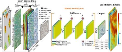
Fine-grained soils are crucial for assessing forest diversity and soil disturbances. Existing models for predicting particle size distributions (PSDs) often rely heavily on soil samples or lack necessary spatial dependencies, scalability and flexibility. This study introduces a holistic GeoAI model using graph neural networks (GNNs), LiDAR, and Sentinel-2 data to address these limitations. We collected 330 soil samples from 47 forest stands with a random-stratified method in southwestern Finland. The samples were pre-processed and analyzed for PSDs using a laser diffraction method, and classified into four groups: <2 µm, 2–6 µm, 6–20 µm, and 20–60 µm. To increase the number of annotations, we predicted soil PSDs at unmeasured locations using CoKriging within stands. The forests were segmented into small homogeneous polygons to construct the graph layer. We mapped 61 covariates using LiDAR and Sentinel-2 based on scorpan model, which were then summarized into the graph layer. Subsequently, we established the pipelines of five GNN models regarding the top covariates. The results indicate that geomorphometry and organisms covariates accounted for the majority of importance. The graph attention network (GAT) recorded high stability during training and remarkable prediction accuracy after testing with R2 values above 0.98 in predicting fine-grained soil PSDs across all four soil groups. Conversely, the relational graph convolutional networks (RGCN) also achieved R2 values above 0.97, but with lower stability and longer training times. However, the high accuracy of the predictive models is partly due to the large number of annotations derived from CoKriging, which may introduce uncertainties. Our GAT model demonstrated strong transferability when applied to an independent test stand using CoKriging-derived data (R2: 0.98–0.99) and showed robust performance when evaluated against real ground-truth samples (R2: 0.88–0.95). The observed prediction errors (RMSE: 0.68–2.82) reflect a combination of uncertainties originating from the CoKriging training data (RMSE: 0.34–2.46) and model-induced errors during training (RMSE: 0.37–1.46). Nevertheless, the consistently high R2 values indicate a strong agreement between predicted and measured soil PSDs. Future studies should focus on training the model with a larger number of ground-truth soil samples and evaluating its transferability across diverse boreal forest landscapes.
期刊介绍:
The International Journal of Applied Earth Observation and Geoinformation publishes original papers that utilize earth observation data for natural resource and environmental inventory and management. These data primarily originate from remote sensing platforms, including satellites and aircraft, supplemented by surface and subsurface measurements. Addressing natural resources such as forests, agricultural land, soils, and water, as well as environmental concerns like biodiversity, land degradation, and hazards, the journal explores conceptual and data-driven approaches. It covers geoinformation themes like capturing, databasing, visualization, interpretation, data quality, and spatial uncertainty.