{"title":"基于PRISMA高光谱数据的喜马拉雅高原比兰加纳地区积雪粒度特征与反演","authors":"Manish Rawat, Ashish Pandey, Dhananjay Paswan Das, Praveen Kumar Gupta","doi":"10.1007/s12518-025-00627-5","DOIUrl":null,"url":null,"abstract":"<div><p>Rapid urbanization processes have significantly increased freshwater consumption, prompting the need for precise predictions of snowmelt-derived streamflow in glacierized Himalayan basins, which are highly susceptible to climate change. However, understanding snow characteristics, such as snow cover and snow grain size, remains a challenge due to inaccessibility of these terrains and the limitations of in-situ data collection. Hyperspectral remote sensing datasets offer a promising solution for monitoring and retrieving snow properties at both micro and macro levels. In this study, the PRISMA hyperspectral dataset was employed to estimate snow grain sizes in the Bhilangana basin of the Upper Himalayan region through the Spectral Angle Mapper (SAM) and Snow Grain Size Index (SGSI) methods. The SGSI approach uses visible and near-infrared wavelengths to classify snow grains, while the SAM method applies endmember spectral signatures validated against the USGS spectral library. The results shows that both SGSI and SAM effectively classified snow grains into fine (< 0.5 mm), medium (0.5–1.0 mm), and coarse (1.0–2.0 mm) categories, achieving a classification accuracy of approximately 88%. The SGSI method utilized the bi-spectral reflectance ratio of PRISMA bands 6 (441.63 nm) and 69 (1028.79 nm) to classify snow grains with spatial variability. The outcomes of the study disclose the competency of PRISMA data for spatial representation of snow grain size variability. The spatial analysis shows that fine and medium grain sizes dominate the snowpack, particularly during the seasonal accumulation observed in February. The findings indicate that fine-grained snow distribution at higher altitudes is crucial for assessing avalanche risks assessment and predicting snowmelt timing. This research demonstrates PRISMA data’s effectiveness in detailed snow grain size mapping, offering valuable insights for applications in climatology, hydrology, and mountain hazard management. Enhanced snow grain size mapping contributes to improved avalanche forecasting and resource planning, ultimately supporting the safety and resilience of the Himalayan mountain regions.</p></div>","PeriodicalId":46286,"journal":{"name":"Applied Geomatics","volume":"17 3","pages":"431 - 447"},"PeriodicalIF":2.3000,"publicationDate":"2025-04-14","publicationTypes":"Journal Article","fieldsOfStudy":null,"isOpenAccess":false,"openAccessPdf":"","citationCount":"0","resultStr":"{\"title\":\"Characterization and retrieval of snow grain size in the Bhilangana region of the Upper Himalayas using hyperspectral PRISMA data\",\"authors\":\"Manish Rawat, Ashish Pandey, Dhananjay Paswan Das, Praveen Kumar Gupta\",\"doi\":\"10.1007/s12518-025-00627-5\",\"DOIUrl\":null,\"url\":null,\"abstract\":\"<div><p>Rapid urbanization processes have significantly increased freshwater consumption, prompting the need for precise predictions of snowmelt-derived streamflow in glacierized Himalayan basins, which are highly susceptible to climate change. However, understanding snow characteristics, such as snow cover and snow grain size, remains a challenge due to inaccessibility of these terrains and the limitations of in-situ data collection. Hyperspectral remote sensing datasets offer a promising solution for monitoring and retrieving snow properties at both micro and macro levels. In this study, the PRISMA hyperspectral dataset was employed to estimate snow grain sizes in the Bhilangana basin of the Upper Himalayan region through the Spectral Angle Mapper (SAM) and Snow Grain Size Index (SGSI) methods. The SGSI approach uses visible and near-infrared wavelengths to classify snow grains, while the SAM method applies endmember spectral signatures validated against the USGS spectral library. The results shows that both SGSI and SAM effectively classified snow grains into fine (< 0.5 mm), medium (0.5–1.0 mm), and coarse (1.0–2.0 mm) categories, achieving a classification accuracy of approximately 88%. The SGSI method utilized the bi-spectral reflectance ratio of PRISMA bands 6 (441.63 nm) and 69 (1028.79 nm) to classify snow grains with spatial variability. The outcomes of the study disclose the competency of PRISMA data for spatial representation of snow grain size variability. The spatial analysis shows that fine and medium grain sizes dominate the snowpack, particularly during the seasonal accumulation observed in February. The findings indicate that fine-grained snow distribution at higher altitudes is crucial for assessing avalanche risks assessment and predicting snowmelt timing. This research demonstrates PRISMA data’s effectiveness in detailed snow grain size mapping, offering valuable insights for applications in climatology, hydrology, and mountain hazard management. Enhanced snow grain size mapping contributes to improved avalanche forecasting and resource planning, ultimately supporting the safety and resilience of the Himalayan mountain regions.</p></div>\",\"PeriodicalId\":46286,\"journal\":{\"name\":\"Applied Geomatics\",\"volume\":\"17 3\",\"pages\":\"431 - 447\"},\"PeriodicalIF\":2.3000,\"publicationDate\":\"2025-04-14\",\"publicationTypes\":\"Journal Article\",\"fieldsOfStudy\":null,\"isOpenAccess\":false,\"openAccessPdf\":\"\",\"citationCount\":\"0\",\"resultStr\":null,\"platform\":\"Semanticscholar\",\"paperid\":null,\"PeriodicalName\":\"Applied Geomatics\",\"FirstCategoryId\":\"1085\",\"ListUrlMain\":\"https://link.springer.com/article/10.1007/s12518-025-00627-5\",\"RegionNum\":0,\"RegionCategory\":null,\"ArticlePicture\":[],\"TitleCN\":null,\"AbstractTextCN\":null,\"PMCID\":null,\"EPubDate\":\"\",\"PubModel\":\"\",\"JCR\":\"Q2\",\"JCRName\":\"REMOTE SENSING\",\"Score\":null,\"Total\":0}","platform":"Semanticscholar","paperid":null,"PeriodicalName":"Applied Geomatics","FirstCategoryId":"1085","ListUrlMain":"https://link.springer.com/article/10.1007/s12518-025-00627-5","RegionNum":0,"RegionCategory":null,"ArticlePicture":[],"TitleCN":null,"AbstractTextCN":null,"PMCID":null,"EPubDate":"","PubModel":"","JCR":"Q2","JCRName":"REMOTE SENSING","Score":null,"Total":0}
Characterization and retrieval of snow grain size in the Bhilangana region of the Upper Himalayas using hyperspectral PRISMA data
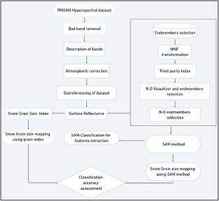
Rapid urbanization processes have significantly increased freshwater consumption, prompting the need for precise predictions of snowmelt-derived streamflow in glacierized Himalayan basins, which are highly susceptible to climate change. However, understanding snow characteristics, such as snow cover and snow grain size, remains a challenge due to inaccessibility of these terrains and the limitations of in-situ data collection. Hyperspectral remote sensing datasets offer a promising solution for monitoring and retrieving snow properties at both micro and macro levels. In this study, the PRISMA hyperspectral dataset was employed to estimate snow grain sizes in the Bhilangana basin of the Upper Himalayan region through the Spectral Angle Mapper (SAM) and Snow Grain Size Index (SGSI) methods. The SGSI approach uses visible and near-infrared wavelengths to classify snow grains, while the SAM method applies endmember spectral signatures validated against the USGS spectral library. The results shows that both SGSI and SAM effectively classified snow grains into fine (< 0.5 mm), medium (0.5–1.0 mm), and coarse (1.0–2.0 mm) categories, achieving a classification accuracy of approximately 88%. The SGSI method utilized the bi-spectral reflectance ratio of PRISMA bands 6 (441.63 nm) and 69 (1028.79 nm) to classify snow grains with spatial variability. The outcomes of the study disclose the competency of PRISMA data for spatial representation of snow grain size variability. The spatial analysis shows that fine and medium grain sizes dominate the snowpack, particularly during the seasonal accumulation observed in February. The findings indicate that fine-grained snow distribution at higher altitudes is crucial for assessing avalanche risks assessment and predicting snowmelt timing. This research demonstrates PRISMA data’s effectiveness in detailed snow grain size mapping, offering valuable insights for applications in climatology, hydrology, and mountain hazard management. Enhanced snow grain size mapping contributes to improved avalanche forecasting and resource planning, ultimately supporting the safety and resilience of the Himalayan mountain regions.
期刊介绍:
Applied Geomatics (AGMJ) is the official journal of SIFET the Italian Society of Photogrammetry and Topography and covers all aspects and information on scientific and technical advances in the geomatics sciences. The Journal publishes innovative contributions in geomatics applications ranging from the integration of instruments, methodologies and technologies and their use in the environmental sciences, engineering and other natural sciences.
The areas of interest include many research fields such as: remote sensing, close range and videometric photogrammetry, image analysis, digital mapping, land and geographic information systems, geographic information science, integrated geodesy, spatial data analysis, heritage recording; network adjustment and numerical processes. Furthermore, Applied Geomatics is open to articles from all areas of deformation measurements and analysis, structural engineering, mechanical engineering and all trends in earth and planetary survey science and space technology. The Journal also contains notices of conferences and international workshops, industry news, and information on new products. It provides a useful forum for professional and academic scientists involved in geomatics science and technology.
Information on Open Research Funding and Support may be found here: https://www.springernature.com/gp/open-research/institutional-agreements

 求助内容:
求助内容: 应助结果提醒方式:


