Chenxi Liu , Wei Gong , Shuo Shi , Tong Wang , Tao Xu , Zixi Shi , Jiayun Niu
{"title":"基于多源遥感融合的深度学习驱动的北方地区森林冠层高度制图:整合Sentinel-1/2、PALSAR和ICESat-2/LVIS数据","authors":"Chenxi Liu , Wei Gong , Shuo Shi , Tong Wang , Tao Xu , Zixi Shi , Jiayun Niu","doi":"10.1016/j.jag.2025.104766","DOIUrl":null,"url":null,"abstract":"<div><div>Forest canopy height is a key indicator for estimating forest carbon sinks and managing vegetation growth. Existing methods for fusing optical and Light Detection and Ranging (LiDAR) data still have limitations in canopy height estimation for boreal forests. In this study, we develop a forest canopy height estimation model (VGG-AdaBins) that leverages convolutional neural networks (CNNs) to extract deep features from multi-source remote sensing data. By introducing an adaptive tree height distribution estimation module, the model enables the coupling of multi-source remote sensing data for forest canopy height estimation. A joint validation dataset is constructed, including Sentinel-1/2, PALSAR images, airborne LVIS LiDAR, and spaceborne ICESat-2 photon-counting LiDAR data. This dataset is used to train the canopy height model. Finally, the performance of the canopy height prediction model is evaluated using 100 independent airborne datasets. The model’s prediction of tree height shows an MAE of 1.42 m and a RMSE of 2.25 m. The predicted 30 m canopy height map exhibits good consistency with the existing airborne data and demonstrated higher accuracy compared with current forest canopy height maps, with an accuracy improvement of at least 20%. The high prediction accuracy demonstrates that VGG-AdaBins, by integrating multi-source remote sensing data, can map continuous canopy height at the regional scale. This approach contributes to the advancement of large-scale canopy height mapping and forest carbon stock assessment in boreal forests.</div></div>","PeriodicalId":73423,"journal":{"name":"International journal of applied earth observation and geoinformation : ITC journal","volume":"143 ","pages":"Article 104766"},"PeriodicalIF":8.6000,"publicationDate":"2025-08-26","publicationTypes":"Journal Article","fieldsOfStudy":null,"isOpenAccess":false,"openAccessPdf":"","citationCount":"0","resultStr":"{\"title\":\"Deep learning-driven forest canopy height mapping in boreal regions through multi-source remote sensing fusion: Integrating Sentinel-1/2, PALSAR, and ICESat-2/LVIS data\",\"authors\":\"Chenxi Liu , Wei Gong , Shuo Shi , Tong Wang , Tao Xu , Zixi Shi , Jiayun Niu\",\"doi\":\"10.1016/j.jag.2025.104766\",\"DOIUrl\":null,\"url\":null,\"abstract\":\"<div><div>Forest canopy height is a key indicator for estimating forest carbon sinks and managing vegetation growth. Existing methods for fusing optical and Light Detection and Ranging (LiDAR) data still have limitations in canopy height estimation for boreal forests. In this study, we develop a forest canopy height estimation model (VGG-AdaBins) that leverages convolutional neural networks (CNNs) to extract deep features from multi-source remote sensing data. By introducing an adaptive tree height distribution estimation module, the model enables the coupling of multi-source remote sensing data for forest canopy height estimation. A joint validation dataset is constructed, including Sentinel-1/2, PALSAR images, airborne LVIS LiDAR, and spaceborne ICESat-2 photon-counting LiDAR data. This dataset is used to train the canopy height model. Finally, the performance of the canopy height prediction model is evaluated using 100 independent airborne datasets. The model’s prediction of tree height shows an MAE of 1.42 m and a RMSE of 2.25 m. The predicted 30 m canopy height map exhibits good consistency with the existing airborne data and demonstrated higher accuracy compared with current forest canopy height maps, with an accuracy improvement of at least 20%. The high prediction accuracy demonstrates that VGG-AdaBins, by integrating multi-source remote sensing data, can map continuous canopy height at the regional scale. This approach contributes to the advancement of large-scale canopy height mapping and forest carbon stock assessment in boreal forests.</div></div>\",\"PeriodicalId\":73423,\"journal\":{\"name\":\"International journal of applied earth observation and geoinformation : ITC journal\",\"volume\":\"143 \",\"pages\":\"Article 104766\"},\"PeriodicalIF\":8.6000,\"publicationDate\":\"2025-08-26\",\"publicationTypes\":\"Journal Article\",\"fieldsOfStudy\":null,\"isOpenAccess\":false,\"openAccessPdf\":\"\",\"citationCount\":\"0\",\"resultStr\":null,\"platform\":\"Semanticscholar\",\"paperid\":null,\"PeriodicalName\":\"International journal of applied earth observation and geoinformation : ITC journal\",\"FirstCategoryId\":\"1085\",\"ListUrlMain\":\"https://www.sciencedirect.com/science/article/pii/S1569843225004133\",\"RegionNum\":0,\"RegionCategory\":null,\"ArticlePicture\":[],\"TitleCN\":null,\"AbstractTextCN\":null,\"PMCID\":null,\"EPubDate\":\"\",\"PubModel\":\"\",\"JCR\":\"Q1\",\"JCRName\":\"REMOTE SENSING\",\"Score\":null,\"Total\":0}","platform":"Semanticscholar","paperid":null,"PeriodicalName":"International journal of applied earth observation and geoinformation : ITC journal","FirstCategoryId":"1085","ListUrlMain":"https://www.sciencedirect.com/science/article/pii/S1569843225004133","RegionNum":0,"RegionCategory":null,"ArticlePicture":[],"TitleCN":null,"AbstractTextCN":null,"PMCID":null,"EPubDate":"","PubModel":"","JCR":"Q1","JCRName":"REMOTE SENSING","Score":null,"Total":0}
Deep learning-driven forest canopy height mapping in boreal regions through multi-source remote sensing fusion: Integrating Sentinel-1/2, PALSAR, and ICESat-2/LVIS data
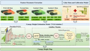
Forest canopy height is a key indicator for estimating forest carbon sinks and managing vegetation growth. Existing methods for fusing optical and Light Detection and Ranging (LiDAR) data still have limitations in canopy height estimation for boreal forests. In this study, we develop a forest canopy height estimation model (VGG-AdaBins) that leverages convolutional neural networks (CNNs) to extract deep features from multi-source remote sensing data. By introducing an adaptive tree height distribution estimation module, the model enables the coupling of multi-source remote sensing data for forest canopy height estimation. A joint validation dataset is constructed, including Sentinel-1/2, PALSAR images, airborne LVIS LiDAR, and spaceborne ICESat-2 photon-counting LiDAR data. This dataset is used to train the canopy height model. Finally, the performance of the canopy height prediction model is evaluated using 100 independent airborne datasets. The model’s prediction of tree height shows an MAE of 1.42 m and a RMSE of 2.25 m. The predicted 30 m canopy height map exhibits good consistency with the existing airborne data and demonstrated higher accuracy compared with current forest canopy height maps, with an accuracy improvement of at least 20%. The high prediction accuracy demonstrates that VGG-AdaBins, by integrating multi-source remote sensing data, can map continuous canopy height at the regional scale. This approach contributes to the advancement of large-scale canopy height mapping and forest carbon stock assessment in boreal forests.
期刊介绍:
The International Journal of Applied Earth Observation and Geoinformation publishes original papers that utilize earth observation data for natural resource and environmental inventory and management. These data primarily originate from remote sensing platforms, including satellites and aircraft, supplemented by surface and subsurface measurements. Addressing natural resources such as forests, agricultural land, soils, and water, as well as environmental concerns like biodiversity, land degradation, and hazards, the journal explores conceptual and data-driven approaches. It covers geoinformation themes like capturing, databasing, visualization, interpretation, data quality, and spatial uncertainty.