Wei Si , Zhixiong Chen , Chi Yung Jim , Ngai Weng Chan , Mou Leong Tan , Bingbing Liu , Dong Liu , Lifei Wei , Shaoyong Wang , Fei Zhang
{"title":"基于创新动态模型池框架解读洱海水体富营养化","authors":"Wei Si , Zhixiong Chen , Chi Yung Jim , Ngai Weng Chan , Mou Leong Tan , Bingbing Liu , Dong Liu , Lifei Wei , Shaoyong Wang , Fei Zhang","doi":"10.1016/j.jag.2025.104808","DOIUrl":null,"url":null,"abstract":"<div><div>Rapid global urbanization has led to water eutrophication, threatening the stability of aquatic ecosystems stability. Chlorophyll-a (Chla), a key indicator of algal biomass, is a widely recognized as a metric for eutrophication. However, existing remote sensing retrieval methods face limitations in addressing complex environmental variations. This study developed an innovative Dynamic Model Pool (DMP) framework to optimize water quality prediction performance dynamically. Using Sentinel-2 satellite imagery and monthly in-situ Chla measurement data from Erhai located in Southwest China spanning 2018 to 2020, this study tested the effectiveness of the DMP framework. The results demonstrated that: (1) The DMP framework dynamically selected the optimal model based on data-specific characteristics. In 2018, the CBR model achieved the highest accuracy, while in 2019, GBR and XGBR were the most accurate. In 2020, GBR outperformed other models. (2) Spatiotemporal Chla distribution maps recorded consistently higher concentrations in the south part of lake, while the central part showed minimal level and variation. (3) Seasonal precipitation and temperature variations and policy implementation were key drivers of Chla concentration changes. Seasonal variations in precipitation and temperature collectively influenced the nutrient input and dilution dynamics in Erhai. Meanwhile, policy interventions implemented between 2018 and 2022, such as pollution interception and wastewater treatment, substantially decreased nutrient inflows during flood seasons and effectively limited nutrient accumulation.</div></div>","PeriodicalId":73423,"journal":{"name":"International journal of applied earth observation and geoinformation : ITC journal","volume":"143 ","pages":"Article 104808"},"PeriodicalIF":8.6000,"publicationDate":"2025-08-22","publicationTypes":"Journal Article","fieldsOfStudy":null,"isOpenAccess":false,"openAccessPdf":"","citationCount":"0","resultStr":"{\"title\":\"Decoding lake water eutrophication using an innovative dynamic model pool framework in Erhai Lake\",\"authors\":\"Wei Si , Zhixiong Chen , Chi Yung Jim , Ngai Weng Chan , Mou Leong Tan , Bingbing Liu , Dong Liu , Lifei Wei , Shaoyong Wang , Fei Zhang\",\"doi\":\"10.1016/j.jag.2025.104808\",\"DOIUrl\":null,\"url\":null,\"abstract\":\"<div><div>Rapid global urbanization has led to water eutrophication, threatening the stability of aquatic ecosystems stability. Chlorophyll-a (Chla), a key indicator of algal biomass, is a widely recognized as a metric for eutrophication. However, existing remote sensing retrieval methods face limitations in addressing complex environmental variations. This study developed an innovative Dynamic Model Pool (DMP) framework to optimize water quality prediction performance dynamically. Using Sentinel-2 satellite imagery and monthly in-situ Chla measurement data from Erhai located in Southwest China spanning 2018 to 2020, this study tested the effectiveness of the DMP framework. The results demonstrated that: (1) The DMP framework dynamically selected the optimal model based on data-specific characteristics. In 2018, the CBR model achieved the highest accuracy, while in 2019, GBR and XGBR were the most accurate. In 2020, GBR outperformed other models. (2) Spatiotemporal Chla distribution maps recorded consistently higher concentrations in the south part of lake, while the central part showed minimal level and variation. (3) Seasonal precipitation and temperature variations and policy implementation were key drivers of Chla concentration changes. Seasonal variations in precipitation and temperature collectively influenced the nutrient input and dilution dynamics in Erhai. Meanwhile, policy interventions implemented between 2018 and 2022, such as pollution interception and wastewater treatment, substantially decreased nutrient inflows during flood seasons and effectively limited nutrient accumulation.</div></div>\",\"PeriodicalId\":73423,\"journal\":{\"name\":\"International journal of applied earth observation and geoinformation : ITC journal\",\"volume\":\"143 \",\"pages\":\"Article 104808\"},\"PeriodicalIF\":8.6000,\"publicationDate\":\"2025-08-22\",\"publicationTypes\":\"Journal Article\",\"fieldsOfStudy\":null,\"isOpenAccess\":false,\"openAccessPdf\":\"\",\"citationCount\":\"0\",\"resultStr\":null,\"platform\":\"Semanticscholar\",\"paperid\":null,\"PeriodicalName\":\"International journal of applied earth observation and geoinformation : ITC journal\",\"FirstCategoryId\":\"1085\",\"ListUrlMain\":\"https://www.sciencedirect.com/science/article/pii/S1569843225004558\",\"RegionNum\":0,\"RegionCategory\":null,\"ArticlePicture\":[],\"TitleCN\":null,\"AbstractTextCN\":null,\"PMCID\":null,\"EPubDate\":\"\",\"PubModel\":\"\",\"JCR\":\"Q1\",\"JCRName\":\"REMOTE SENSING\",\"Score\":null,\"Total\":0}","platform":"Semanticscholar","paperid":null,"PeriodicalName":"International journal of applied earth observation and geoinformation : ITC journal","FirstCategoryId":"1085","ListUrlMain":"https://www.sciencedirect.com/science/article/pii/S1569843225004558","RegionNum":0,"RegionCategory":null,"ArticlePicture":[],"TitleCN":null,"AbstractTextCN":null,"PMCID":null,"EPubDate":"","PubModel":"","JCR":"Q1","JCRName":"REMOTE SENSING","Score":null,"Total":0}
引用次数: 0
摘要
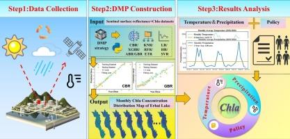
全球快速城市化导致水体富营养化,威胁着水生生态系统的稳定。叶绿素a (Chla)是藻类生物量的重要指标,被广泛认为是富营养化的度量指标。然而,现有的遥感检索方法在处理复杂的环境变化方面存在局限性。本研究开发了一个创新的动态模型池(Dynamic Model Pool, DMP)框架,以动态优化水质预测性能。利用2018 - 2020年中国西南部洱海的Sentinel-2卫星图像和每月原位Chla测量数据,本研究验证了DMP框架的有效性。结果表明:(1)DMP框架根据数据的特定特征动态选择最优模型。2018年,CBR模型的准确率最高,而2019年,GBR和XGBR模型的准确率最高。2020年,GBR表现优于其他模型。(2) Chla时空分布图显示,湖泊南部Chla浓度持续较高,中部Chla浓度变化最小。(3)季节降水、气温变化和政策实施是Chla浓度变化的主要驱动因素。降水和温度的季节变化共同影响洱海的养分输入和稀释动态。与此同时,2018年至2022年期间实施的污染拦截和废水处理等政策干预措施大幅减少了汛期养分流入,有效限制了养分积累。
Decoding lake water eutrophication using an innovative dynamic model pool framework in Erhai Lake
Rapid global urbanization has led to water eutrophication, threatening the stability of aquatic ecosystems stability. Chlorophyll-a (Chla), a key indicator of algal biomass, is a widely recognized as a metric for eutrophication. However, existing remote sensing retrieval methods face limitations in addressing complex environmental variations. This study developed an innovative Dynamic Model Pool (DMP) framework to optimize water quality prediction performance dynamically. Using Sentinel-2 satellite imagery and monthly in-situ Chla measurement data from Erhai located in Southwest China spanning 2018 to 2020, this study tested the effectiveness of the DMP framework. The results demonstrated that: (1) The DMP framework dynamically selected the optimal model based on data-specific characteristics. In 2018, the CBR model achieved the highest accuracy, while in 2019, GBR and XGBR were the most accurate. In 2020, GBR outperformed other models. (2) Spatiotemporal Chla distribution maps recorded consistently higher concentrations in the south part of lake, while the central part showed minimal level and variation. (3) Seasonal precipitation and temperature variations and policy implementation were key drivers of Chla concentration changes. Seasonal variations in precipitation and temperature collectively influenced the nutrient input and dilution dynamics in Erhai. Meanwhile, policy interventions implemented between 2018 and 2022, such as pollution interception and wastewater treatment, substantially decreased nutrient inflows during flood seasons and effectively limited nutrient accumulation.
期刊介绍:
The International Journal of Applied Earth Observation and Geoinformation publishes original papers that utilize earth observation data for natural resource and environmental inventory and management. These data primarily originate from remote sensing platforms, including satellites and aircraft, supplemented by surface and subsurface measurements. Addressing natural resources such as forests, agricultural land, soils, and water, as well as environmental concerns like biodiversity, land degradation, and hazards, the journal explores conceptual and data-driven approaches. It covers geoinformation themes like capturing, databasing, visualization, interpretation, data quality, and spatial uncertainty.