Gerard E Ryan, Nicholas Tierney, Nick Golding, Daniel J Weiss
{"title":"traveltime:一个R包,用于计算从用户指定位置穿越景观所需的时间。","authors":"Gerard E Ryan, Nicholas Tierney, Nick Golding, Daniel J Weiss","doi":"10.12688/gatesopenres.16356.1","DOIUrl":null,"url":null,"abstract":"<p><p>Understanding and mapping the time to travel among locations is useful for many activities from urban planning to public health and myriad others. Here we present a software package - traveltime - written in and for the language R. traveltime enables a user to create a raster map of the travel time over an area of interest from a user-specified set of locations defined by geographic coordinates. The result is a raster of the area of interest where the value in each cell is the lowest travel time in minutes to the nearest of the supplied locations. We envisage this software having diverse applications including: estimating sampling bias, allocating defibrillators, setting health districts, or mapping access to vehicle chargers and agricultural facilities. The work-flow requires two key steps: preparing a friction surface for the area of interest, and then calculating travel time over that surface for the points of interest. traveltime is available from R-Universe and GitHub, and documented at https://idem-lab.github.io/traveltime/.</p>","PeriodicalId":12593,"journal":{"name":"Gates Open Research","volume":"9 ","pages":"50"},"PeriodicalIF":0.0000,"publicationDate":"2025-07-24","publicationTypes":"Journal Article","fieldsOfStudy":null,"isOpenAccess":false,"openAccessPdf":"https://www.ncbi.nlm.nih.gov/pmc/articles/PMC12290219/pdf/","citationCount":"0","resultStr":"{\"title\":\"traveltime: an R package to calculate travel time across a landscape from user-specified locations.\",\"authors\":\"Gerard E Ryan, Nicholas Tierney, Nick Golding, Daniel J Weiss\",\"doi\":\"10.12688/gatesopenres.16356.1\",\"DOIUrl\":null,\"url\":null,\"abstract\":\"<p><p>Understanding and mapping the time to travel among locations is useful for many activities from urban planning to public health and myriad others. Here we present a software package - traveltime - written in and for the language R. traveltime enables a user to create a raster map of the travel time over an area of interest from a user-specified set of locations defined by geographic coordinates. The result is a raster of the area of interest where the value in each cell is the lowest travel time in minutes to the nearest of the supplied locations. We envisage this software having diverse applications including: estimating sampling bias, allocating defibrillators, setting health districts, or mapping access to vehicle chargers and agricultural facilities. The work-flow requires two key steps: preparing a friction surface for the area of interest, and then calculating travel time over that surface for the points of interest. traveltime is available from R-Universe and GitHub, and documented at https://idem-lab.github.io/traveltime/.</p>\",\"PeriodicalId\":12593,\"journal\":{\"name\":\"Gates Open Research\",\"volume\":\"9 \",\"pages\":\"50\"},\"PeriodicalIF\":0.0000,\"publicationDate\":\"2025-07-24\",\"publicationTypes\":\"Journal Article\",\"fieldsOfStudy\":null,\"isOpenAccess\":false,\"openAccessPdf\":\"https://www.ncbi.nlm.nih.gov/pmc/articles/PMC12290219/pdf/\",\"citationCount\":\"0\",\"resultStr\":null,\"platform\":\"Semanticscholar\",\"paperid\":null,\"PeriodicalName\":\"Gates Open Research\",\"FirstCategoryId\":\"1085\",\"ListUrlMain\":\"https://doi.org/10.12688/gatesopenres.16356.1\",\"RegionNum\":0,\"RegionCategory\":null,\"ArticlePicture\":[],\"TitleCN\":null,\"AbstractTextCN\":null,\"PMCID\":null,\"EPubDate\":\"2025/1/1 0:00:00\",\"PubModel\":\"eCollection\",\"JCR\":\"\",\"JCRName\":\"\",\"Score\":null,\"Total\":0}","platform":"Semanticscholar","paperid":null,"PeriodicalName":"Gates Open Research","FirstCategoryId":"1085","ListUrlMain":"https://doi.org/10.12688/gatesopenres.16356.1","RegionNum":0,"RegionCategory":null,"ArticlePicture":[],"TitleCN":null,"AbstractTextCN":null,"PMCID":null,"EPubDate":"2025/1/1 0:00:00","PubModel":"eCollection","JCR":"","JCRName":"","Score":null,"Total":0}
traveltime: an R package to calculate travel time across a landscape from user-specified locations.
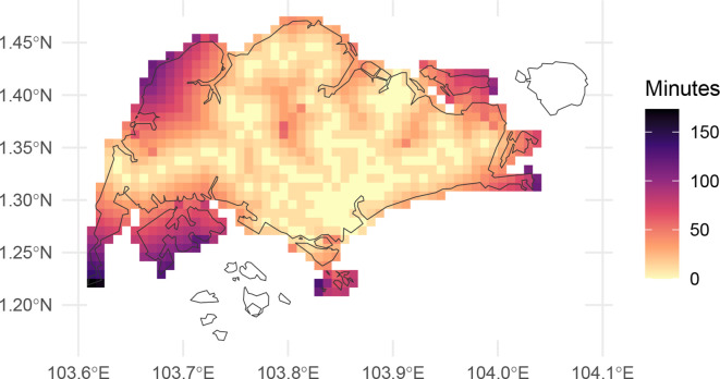
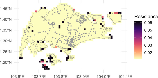
Understanding and mapping the time to travel among locations is useful for many activities from urban planning to public health and myriad others. Here we present a software package - traveltime - written in and for the language R. traveltime enables a user to create a raster map of the travel time over an area of interest from a user-specified set of locations defined by geographic coordinates. The result is a raster of the area of interest where the value in each cell is the lowest travel time in minutes to the nearest of the supplied locations. We envisage this software having diverse applications including: estimating sampling bias, allocating defibrillators, setting health districts, or mapping access to vehicle chargers and agricultural facilities. The work-flow requires two key steps: preparing a friction surface for the area of interest, and then calculating travel time over that surface for the points of interest. traveltime is available from R-Universe and GitHub, and documented at https://idem-lab.github.io/traveltime/.

 求助内容:
求助内容: 应助结果提醒方式:


