按需的语义EO数据立方体——基于知识的多模态数据的语义查询,用于地球上任何地方的中尺度分析

IF 12.2 1区 地球科学 Q1 GEOGRAPHY, PHYSICAL
Felix Kröber , Martin Sudmanns , Lorena Abad , Dirk Tiede
{"title":"按需的语义EO数据立方体——基于知识的多模态数据的语义查询,用于地球上任何地方的中尺度分析","authors":"Felix Kröber ,&nbsp;Martin Sudmanns ,&nbsp;Lorena Abad ,&nbsp;Dirk Tiede","doi":"10.1016/j.isprsjprs.2025.07.015","DOIUrl":null,"url":null,"abstract":"<div><div>With the daily increasing amount of available Earth Observation (EO) data, the importance of processing frameworks that allow users to focus on the actual analysis of the data instead of the technical and conceptual complexity of data access and integration is growing. In this context, we present a Python-based implementation of ad-hoc data cubes to perform big EO data analysis in a few lines of code. In contrast to existing data cube frameworks, our semantic, knowledge-based approach enables data to be processed beyond its simple numerical representation, with structured integration and communication of expert knowledge from the relevant domains. The technical foundations for this are threefold: Firstly, on-demand fetching of data in cloud-optimized formats via SpatioTemporal Asset Catalog (STAC) standardized metadata to regularized three-dimensional data cubes. Secondly, provision of a semantic language along with an analysis structure that enables to address data and create knowledge-based models. And thirdly, chunking and parallelization mechanisms to execute the created models in a scalable and efficient manner. From the user’s point of view, big EO data archives can be analyzed both on local, commercially available devices and on cloud-based processing infrastructures without being tied to a specific platform. Visualization options for models enable effective exchange with end users and domain experts regarding the design of analyses. The concrete benefits of the presented framework are demonstrated using two application examples relevant for environmental monitoring: querying cloud-free data and analyzing the extent of forest disturbance areas.</div></div>","PeriodicalId":50269,"journal":{"name":"ISPRS Journal of Photogrammetry and Remote Sensing","volume":"228 ","pages":"Pages 552-565"},"PeriodicalIF":12.2000,"publicationDate":"2025-07-29","publicationTypes":"Journal Article","fieldsOfStudy":null,"isOpenAccess":false,"openAccessPdf":"","citationCount":"0","resultStr":"{\"title\":\"On-demand, semantic EO data cubes – knowledge-based, semantic querying of multimodal data for mesoscale analyses anywhere on Earth\",\"authors\":\"Felix Kröber ,&nbsp;Martin Sudmanns ,&nbsp;Lorena Abad ,&nbsp;Dirk Tiede\",\"doi\":\"10.1016/j.isprsjprs.2025.07.015\",\"DOIUrl\":null,\"url\":null,\"abstract\":\"<div><div>With the daily increasing amount of available Earth Observation (EO) data, the importance of processing frameworks that allow users to focus on the actual analysis of the data instead of the technical and conceptual complexity of data access and integration is growing. In this context, we present a Python-based implementation of ad-hoc data cubes to perform big EO data analysis in a few lines of code. In contrast to existing data cube frameworks, our semantic, knowledge-based approach enables data to be processed beyond its simple numerical representation, with structured integration and communication of expert knowledge from the relevant domains. The technical foundations for this are threefold: Firstly, on-demand fetching of data in cloud-optimized formats via SpatioTemporal Asset Catalog (STAC) standardized metadata to regularized three-dimensional data cubes. Secondly, provision of a semantic language along with an analysis structure that enables to address data and create knowledge-based models. And thirdly, chunking and parallelization mechanisms to execute the created models in a scalable and efficient manner. From the user’s point of view, big EO data archives can be analyzed both on local, commercially available devices and on cloud-based processing infrastructures without being tied to a specific platform. Visualization options for models enable effective exchange with end users and domain experts regarding the design of analyses. The concrete benefits of the presented framework are demonstrated using two application examples relevant for environmental monitoring: querying cloud-free data and analyzing the extent of forest disturbance areas.</div></div>\",\"PeriodicalId\":50269,\"journal\":{\"name\":\"ISPRS Journal of Photogrammetry and Remote Sensing\",\"volume\":\"228 \",\"pages\":\"Pages 552-565\"},\"PeriodicalIF\":12.2000,\"publicationDate\":\"2025-07-29\",\"publicationTypes\":\"Journal Article\",\"fieldsOfStudy\":null,\"isOpenAccess\":false,\"openAccessPdf\":\"\",\"citationCount\":\"0\",\"resultStr\":null,\"platform\":\"Semanticscholar\",\"paperid\":null,\"PeriodicalName\":\"ISPRS Journal of Photogrammetry and Remote Sensing\",\"FirstCategoryId\":\"5\",\"ListUrlMain\":\"https://www.sciencedirect.com/science/article/pii/S092427162500276X\",\"RegionNum\":1,\"RegionCategory\":\"地球科学\",\"ArticlePicture\":[],\"TitleCN\":null,\"AbstractTextCN\":null,\"PMCID\":null,\"EPubDate\":\"\",\"PubModel\":\"\",\"JCR\":\"Q1\",\"JCRName\":\"GEOGRAPHY, PHYSICAL\",\"Score\":null,\"Total\":0}","platform":"Semanticscholar","paperid":null,"PeriodicalName":"ISPRS Journal of Photogrammetry and Remote Sensing","FirstCategoryId":"5","ListUrlMain":"https://www.sciencedirect.com/science/article/pii/S092427162500276X","RegionNum":1,"RegionCategory":"地球科学","ArticlePicture":[],"TitleCN":null,"AbstractTextCN":null,"PMCID":null,"EPubDate":"","PubModel":"","JCR":"Q1","JCRName":"GEOGRAPHY, PHYSICAL","Score":null,"Total":0}
引用次数: 0

摘要

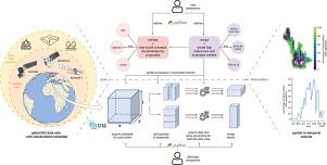
随着可用地球观测(EO)数据量的日益增加,处理框架的重要性日益增加,这些框架允许用户专注于数据的实际分析,而不是数据访问和集成的技术和概念复杂性。在这种情况下,我们提供了一个基于python的临时数据集实现,通过几行代码执行大型EO数据分析。与现有的数据立方体框架相比,我们的语义、基于知识的方法使数据能够超越简单的数字表示进行处理,并与相关领域的专家知识进行结构化集成和交流。其技术基础有三个方面:首先,通过时空资产目录(STAC)标准化元数据按需提取云优化格式的数据到正则化的三维数据立方体。其次,提供语义语言和分析结构,使处理数据和创建基于知识的模型成为可能。第三,分块和并行化机制,以可伸缩和有效的方式执行创建的模型。从用户的角度来看,可以在本地商用设备和基于云的处理基础设施上分析大型EO数据档案,而无需绑定到特定平台。模型的可视化选项支持与最终用户和领域专家就分析设计进行有效的交换。通过两个与环境监测相关的应用实例:查询无云数据和分析森林干扰区的范围,展示了所提出框架的具体好处。
本文章由计算机程序翻译,如有差异,请以英文原文为准。

On-demand, semantic EO data cubes – knowledge-based, semantic querying of multimodal data for mesoscale analyses anywhere on Earth

On-demand, semantic EO data cubes – knowledge-based, semantic querying of multimodal data for mesoscale analyses anywhere on Earth
With the daily increasing amount of available Earth Observation (EO) data, the importance of processing frameworks that allow users to focus on the actual analysis of the data instead of the technical and conceptual complexity of data access and integration is growing. In this context, we present a Python-based implementation of ad-hoc data cubes to perform big EO data analysis in a few lines of code. In contrast to existing data cube frameworks, our semantic, knowledge-based approach enables data to be processed beyond its simple numerical representation, with structured integration and communication of expert knowledge from the relevant domains. The technical foundations for this are threefold: Firstly, on-demand fetching of data in cloud-optimized formats via SpatioTemporal Asset Catalog (STAC) standardized metadata to regularized three-dimensional data cubes. Secondly, provision of a semantic language along with an analysis structure that enables to address data and create knowledge-based models. And thirdly, chunking and parallelization mechanisms to execute the created models in a scalable and efficient manner. From the user’s point of view, big EO data archives can be analyzed both on local, commercially available devices and on cloud-based processing infrastructures without being tied to a specific platform. Visualization options for models enable effective exchange with end users and domain experts regarding the design of analyses. The concrete benefits of the presented framework are demonstrated using two application examples relevant for environmental monitoring: querying cloud-free data and analyzing the extent of forest disturbance areas.
求助全文
通过发布文献求助,成功后即可免费获取论文全文。 去求助
来源期刊
ISPRS Journal of Photogrammetry and Remote Sensing
ISPRS Journal of Photogrammetry and Remote Sensing 工程技术-成像科学与照相技术
CiteScore
21.00
自引率
6.30%
发文量
273
审稿时长
40 days
期刊介绍: The ISPRS Journal of Photogrammetry and Remote Sensing (P&RS) serves as the official journal of the International Society for Photogrammetry and Remote Sensing (ISPRS). It acts as a platform for scientists and professionals worldwide who are involved in various disciplines that utilize photogrammetry, remote sensing, spatial information systems, computer vision, and related fields. The journal aims to facilitate communication and dissemination of advancements in these disciplines, while also acting as a comprehensive source of reference and archive. P&RS endeavors to publish high-quality, peer-reviewed research papers that are preferably original and have not been published before. These papers can cover scientific/research, technological development, or application/practical aspects. Additionally, the journal welcomes papers that are based on presentations from ISPRS meetings, as long as they are considered significant contributions to the aforementioned fields. In particular, P&RS encourages the submission of papers that are of broad scientific interest, showcase innovative applications (especially in emerging fields), have an interdisciplinary focus, discuss topics that have received limited attention in P&RS or related journals, or explore new directions in scientific or professional realms. It is preferred that theoretical papers include practical applications, while papers focusing on systems and applications should include a theoretical background.
×
引用
GB/T 7714-2015
复制
MLA
复制
APA
复制
导出至
BibTeX EndNote RefMan NoteFirst NoteExpress
×
提示
您的信息不完整,为了账户安全,请先补充。
现在去补充
×
提示
您因"违规操作"
具体请查看互助需知
我知道了
×
提示
确定
请完成安全验证×
copy
已复制链接
快去分享给好友吧!
我知道了
右上角分享
点击右上角分享
0
联系我们:info@booksci.cn Book学术提供免费学术资源搜索服务,方便国内外学者检索中英文文献。致力于提供最便捷和优质的服务体验。 Copyright © 2023 布克学术 All rights reserved.
京ICP备2023020795号-1
ghs 京公网安备 11010802042870号
Book学术文献互助
Book学术文献互助群
群 号:604180095
Book学术官方微信