推进InSAR分析:线性和非线性位移建模的TimeSAPS

IF 4.5 Q2 ENVIRONMENTAL SCIENCES
Eugenia Giorgini , Luca Tavasci , Enrica Vecchi , Luca Poluzzi , Stefano Gandolfi
{"title":"推进InSAR分析:线性和非线性位移建模的TimeSAPS","authors":"Eugenia Giorgini ,&nbsp;Luca Tavasci ,&nbsp;Enrica Vecchi ,&nbsp;Luca Poluzzi ,&nbsp;Stefano Gandolfi","doi":"10.1016/j.rsase.2025.101656","DOIUrl":null,"url":null,"abstract":"<div><div>The Synthetic Aperture Radar Interferometry (InSAR) technique enables precise monitoring of ground displacements over extensive areas based on radar data. While several open-source software packages have been developed for SAR data processing, most retrieve the average velocity of Persistent Scatterers (PS) clusters under the assumption of linear behavior, limiting their application in complex scenarios.</div><div>To enable more advanced and detailed analysis of InSAR time series, the TimeSAPS software package has been developed. This tool addresses the limitations of existing open-source packages, which primarily focus on linear approximations of displacement time series, by introducing advanced capabilities for analyzing both linear trends and nonlinear components. TimeSAPS performs a comprehensive analysis of PS derived from InSAR processing, characterizing time series in terms of linear trends, periodic signals, and nonlinear movements. Nonlinear components are modeled as a combination of sinusoids, each defined by its phase, amplitude, and frequency power spectrum. TimeSAPS overcomes the limitations of existing tools by providing advanced methods to recognize and model nonlinear surface movements, even when they are not known a priori.</div><div>This paper presents the theoretical foundations of TimeSAPS and demonstrates its capabilities through two case studies based on real InSAR data. These examples showcase the software’s effectiveness in reconstructing nonlinear displacement patterns and identifying periodic trends. The results underline TimeSAPS’s potential to analyze complex ground displacement scenarios, making it a valuable resource for the scientific and engineering communities.</div></div>","PeriodicalId":53227,"journal":{"name":"Remote Sensing Applications-Society and Environment","volume":"39 ","pages":"Article 101656"},"PeriodicalIF":4.5000,"publicationDate":"2025-07-17","publicationTypes":"Journal Article","fieldsOfStudy":null,"isOpenAccess":false,"openAccessPdf":"","citationCount":"0","resultStr":"{\"title\":\"Advancing InSAR analysis: TimeSAPS for linear and nonlinear displacement modeling\",\"authors\":\"Eugenia Giorgini ,&nbsp;Luca Tavasci ,&nbsp;Enrica Vecchi ,&nbsp;Luca Poluzzi ,&nbsp;Stefano Gandolfi\",\"doi\":\"10.1016/j.rsase.2025.101656\",\"DOIUrl\":null,\"url\":null,\"abstract\":\"<div><div>The Synthetic Aperture Radar Interferometry (InSAR) technique enables precise monitoring of ground displacements over extensive areas based on radar data. While several open-source software packages have been developed for SAR data processing, most retrieve the average velocity of Persistent Scatterers (PS) clusters under the assumption of linear behavior, limiting their application in complex scenarios.</div><div>To enable more advanced and detailed analysis of InSAR time series, the TimeSAPS software package has been developed. This tool addresses the limitations of existing open-source packages, which primarily focus on linear approximations of displacement time series, by introducing advanced capabilities for analyzing both linear trends and nonlinear components. TimeSAPS performs a comprehensive analysis of PS derived from InSAR processing, characterizing time series in terms of linear trends, periodic signals, and nonlinear movements. Nonlinear components are modeled as a combination of sinusoids, each defined by its phase, amplitude, and frequency power spectrum. TimeSAPS overcomes the limitations of existing tools by providing advanced methods to recognize and model nonlinear surface movements, even when they are not known a priori.</div><div>This paper presents the theoretical foundations of TimeSAPS and demonstrates its capabilities through two case studies based on real InSAR data. These examples showcase the software’s effectiveness in reconstructing nonlinear displacement patterns and identifying periodic trends. The results underline TimeSAPS’s potential to analyze complex ground displacement scenarios, making it a valuable resource for the scientific and engineering communities.</div></div>\",\"PeriodicalId\":53227,\"journal\":{\"name\":\"Remote Sensing Applications-Society and Environment\",\"volume\":\"39 \",\"pages\":\"Article 101656\"},\"PeriodicalIF\":4.5000,\"publicationDate\":\"2025-07-17\",\"publicationTypes\":\"Journal Article\",\"fieldsOfStudy\":null,\"isOpenAccess\":false,\"openAccessPdf\":\"\",\"citationCount\":\"0\",\"resultStr\":null,\"platform\":\"Semanticscholar\",\"paperid\":null,\"PeriodicalName\":\"Remote Sensing Applications-Society and Environment\",\"FirstCategoryId\":\"1085\",\"ListUrlMain\":\"https://www.sciencedirect.com/science/article/pii/S2352938525002095\",\"RegionNum\":0,\"RegionCategory\":null,\"ArticlePicture\":[],\"TitleCN\":null,\"AbstractTextCN\":null,\"PMCID\":null,\"EPubDate\":\"\",\"PubModel\":\"\",\"JCR\":\"Q2\",\"JCRName\":\"ENVIRONMENTAL SCIENCES\",\"Score\":null,\"Total\":0}","platform":"Semanticscholar","paperid":null,"PeriodicalName":"Remote Sensing Applications-Society and Environment","FirstCategoryId":"1085","ListUrlMain":"https://www.sciencedirect.com/science/article/pii/S2352938525002095","RegionNum":0,"RegionCategory":null,"ArticlePicture":[],"TitleCN":null,"AbstractTextCN":null,"PMCID":null,"EPubDate":"","PubModel":"","JCR":"Q2","JCRName":"ENVIRONMENTAL SCIENCES","Score":null,"Total":0}
引用次数: 0

摘要

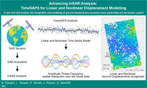
合成孔径雷达干涉测量(InSAR)技术可以根据雷达数据对大面积的地面位移进行精确监测。虽然已经开发了一些用于SAR数据处理的开源软件包,但大多数软件包都是在线性行为假设下检索持久散射体(PS)簇的平均速度,限制了它们在复杂场景中的应用。为了能够对InSAR时间序列进行更高级和详细的分析,开发了TimeSAPS软件包。该工具通过引入分析线性趋势和非线性组件的高级功能,解决了现有开源软件包的局限性,这些软件包主要关注位移时间序列的线性近似。TimeSAPS对来自InSAR处理的PS进行全面分析,从线性趋势、周期信号和非线性运动方面描述时间序列。非线性分量被建模为正弦波的组合,每个正弦波都由其相位、幅度和频率功率谱来定义。TimeSAPS通过提供先进的方法来识别和模拟非线性表面运动,克服了现有工具的局限性,即使这些运动是未知的。本文介绍了TimeSAPS的理论基础,并通过两个基于真实InSAR数据的案例分析验证了其功能。这些例子展示了该软件在重建非线性位移模式和识别周期性趋势方面的有效性。这些结果强调了TimeSAPS分析复杂地面位移情景的潜力,使其成为科学和工程界的宝贵资源。
本文章由计算机程序翻译,如有差异,请以英文原文为准。

Advancing InSAR analysis: TimeSAPS for linear and nonlinear displacement modeling

Advancing InSAR analysis: TimeSAPS for linear and nonlinear displacement modeling
The Synthetic Aperture Radar Interferometry (InSAR) technique enables precise monitoring of ground displacements over extensive areas based on radar data. While several open-source software packages have been developed for SAR data processing, most retrieve the average velocity of Persistent Scatterers (PS) clusters under the assumption of linear behavior, limiting their application in complex scenarios.
To enable more advanced and detailed analysis of InSAR time series, the TimeSAPS software package has been developed. This tool addresses the limitations of existing open-source packages, which primarily focus on linear approximations of displacement time series, by introducing advanced capabilities for analyzing both linear trends and nonlinear components. TimeSAPS performs a comprehensive analysis of PS derived from InSAR processing, characterizing time series in terms of linear trends, periodic signals, and nonlinear movements. Nonlinear components are modeled as a combination of sinusoids, each defined by its phase, amplitude, and frequency power spectrum. TimeSAPS overcomes the limitations of existing tools by providing advanced methods to recognize and model nonlinear surface movements, even when they are not known a priori.
This paper presents the theoretical foundations of TimeSAPS and demonstrates its capabilities through two case studies based on real InSAR data. These examples showcase the software’s effectiveness in reconstructing nonlinear displacement patterns and identifying periodic trends. The results underline TimeSAPS’s potential to analyze complex ground displacement scenarios, making it a valuable resource for the scientific and engineering communities.
求助全文
通过发布文献求助,成功后即可免费获取论文全文。 去求助
来源期刊
CiteScore
8.00
自引率
8.50%
发文量
204
审稿时长
65 days
期刊介绍: The journal ''Remote Sensing Applications: Society and Environment'' (RSASE) focuses on remote sensing studies that address specific topics with an emphasis on environmental and societal issues - regional / local studies with global significance. Subjects are encouraged to have an interdisciplinary approach and include, but are not limited by: " -Global and climate change studies addressing the impact of increasing concentrations of greenhouse gases, CO2 emission, carbon balance and carbon mitigation, energy system on social and environmental systems -Ecological and environmental issues including biodiversity, ecosystem dynamics, land degradation, atmospheric and water pollution, urban footprint, ecosystem management and natural hazards (e.g. earthquakes, typhoons, floods, landslides) -Natural resource studies including land-use in general, biomass estimation, forests, agricultural land, plantation, soils, coral reefs, wetland and water resources -Agriculture, food production systems and food security outcomes -Socio-economic issues including urban systems, urban growth, public health, epidemics, land-use transition and land use conflicts -Oceanography and coastal zone studies, including sea level rise projections, coastlines changes and the ocean-land interface -Regional challenges for remote sensing application techniques, monitoring and analysis, such as cloud screening and atmospheric correction for tropical regions -Interdisciplinary studies combining remote sensing, household survey data, field measurements and models to address environmental, societal and sustainability issues -Quantitative and qualitative analysis that documents the impact of using remote sensing studies in social, political, environmental or economic systems
×
引用
GB/T 7714-2015
复制
MLA
复制
APA
复制
导出至
BibTeX EndNote RefMan NoteFirst NoteExpress
×
提示
您的信息不完整,为了账户安全,请先补充。
现在去补充
×
提示
您因"违规操作"
具体请查看互助需知
我知道了
×
提示
确定
请完成安全验证×
copy
已复制链接
快去分享给好友吧!
我知道了
右上角分享
点击右上角分享
0
联系我们:info@booksci.cn Book学术提供免费学术资源搜索服务,方便国内外学者检索中英文文献。致力于提供最便捷和优质的服务体验。 Copyright © 2023 布克学术 All rights reserved.
京ICP备2023020795号-1
ghs 京公网安备 11010802042870号
Book学术文献互助
Book学术文献互助群
群 号:604180095
Book学术官方微信