{"title":"衡量和可视化美国多维贫困的综合空间框架和协同设计工具包","authors":"Sarbeswar Praharaj","doi":"10.1111/gean.12420","DOIUrl":null,"url":null,"abstract":"<p>Nearly 38 million people in the United States live in poverty. The Census Bureau's official poverty measure significantly undercounts poverty as it solely focuses on a minimum food diet and fails to account for the geographic variations in living costs. This article offers a geographically adaptive framework for combining multidimensional poverty indicators and modeling the locally adjusted costs of food, housing and utilities, healthcare, childcare, transportation, taxes, and other necessities to assess poverty and geographic inequality across neighborhoods and population sub-groups. We employ a co-design approach for developing the poverty assessment framework and evaluating the results with end users to ensure that communities can build trust and a sense of ownership that enhances the usability and actionability of poverty data. The datasets, quantitative frameworks, and algorithms were woven into an interactive geospatial dashboard toolkit for seamlessly integrating, cleaning, standardizing, and visually communicating the poverty metrics with a broad range of users. Results from this paper advance spatial data analyses and reproducible spatial model-building methods that enable researchers to gain higher resolution, context-specific, and geographically dynamic knowledge of poverty and inequalities.</p>","PeriodicalId":12533,"journal":{"name":"Geographical Analysis","volume":"57 3","pages":"355-369"},"PeriodicalIF":4.3000,"publicationDate":"2025-01-28","publicationTypes":"Journal Article","fieldsOfStudy":null,"isOpenAccess":false,"openAccessPdf":"https://onlinelibrary.wiley.com/doi/epdf/10.1111/gean.12420","citationCount":"0","resultStr":"{\"title\":\"An Integrative Spatial Framework and Co-Design Toolkit to Measure and Visualize Multidimensional Poverty in the United States\",\"authors\":\"Sarbeswar Praharaj\",\"doi\":\"10.1111/gean.12420\",\"DOIUrl\":null,\"url\":null,\"abstract\":\"<p>Nearly 38 million people in the United States live in poverty. The Census Bureau's official poverty measure significantly undercounts poverty as it solely focuses on a minimum food diet and fails to account for the geographic variations in living costs. This article offers a geographically adaptive framework for combining multidimensional poverty indicators and modeling the locally adjusted costs of food, housing and utilities, healthcare, childcare, transportation, taxes, and other necessities to assess poverty and geographic inequality across neighborhoods and population sub-groups. We employ a co-design approach for developing the poverty assessment framework and evaluating the results with end users to ensure that communities can build trust and a sense of ownership that enhances the usability and actionability of poverty data. The datasets, quantitative frameworks, and algorithms were woven into an interactive geospatial dashboard toolkit for seamlessly integrating, cleaning, standardizing, and visually communicating the poverty metrics with a broad range of users. Results from this paper advance spatial data analyses and reproducible spatial model-building methods that enable researchers to gain higher resolution, context-specific, and geographically dynamic knowledge of poverty and inequalities.</p>\",\"PeriodicalId\":12533,\"journal\":{\"name\":\"Geographical Analysis\",\"volume\":\"57 3\",\"pages\":\"355-369\"},\"PeriodicalIF\":4.3000,\"publicationDate\":\"2025-01-28\",\"publicationTypes\":\"Journal Article\",\"fieldsOfStudy\":null,\"isOpenAccess\":false,\"openAccessPdf\":\"https://onlinelibrary.wiley.com/doi/epdf/10.1111/gean.12420\",\"citationCount\":\"0\",\"resultStr\":null,\"platform\":\"Semanticscholar\",\"paperid\":null,\"PeriodicalName\":\"Geographical Analysis\",\"FirstCategoryId\":\"89\",\"ListUrlMain\":\"https://onlinelibrary.wiley.com/doi/10.1111/gean.12420\",\"RegionNum\":3,\"RegionCategory\":\"地球科学\",\"ArticlePicture\":[],\"TitleCN\":null,\"AbstractTextCN\":null,\"PMCID\":null,\"EPubDate\":\"\",\"PubModel\":\"\",\"JCR\":\"Q1\",\"JCRName\":\"GEOGRAPHY\",\"Score\":null,\"Total\":0}","platform":"Semanticscholar","paperid":null,"PeriodicalName":"Geographical Analysis","FirstCategoryId":"89","ListUrlMain":"https://onlinelibrary.wiley.com/doi/10.1111/gean.12420","RegionNum":3,"RegionCategory":"地球科学","ArticlePicture":[],"TitleCN":null,"AbstractTextCN":null,"PMCID":null,"EPubDate":"","PubModel":"","JCR":"Q1","JCRName":"GEOGRAPHY","Score":null,"Total":0}
An Integrative Spatial Framework and Co-Design Toolkit to Measure and Visualize Multidimensional Poverty in the United States
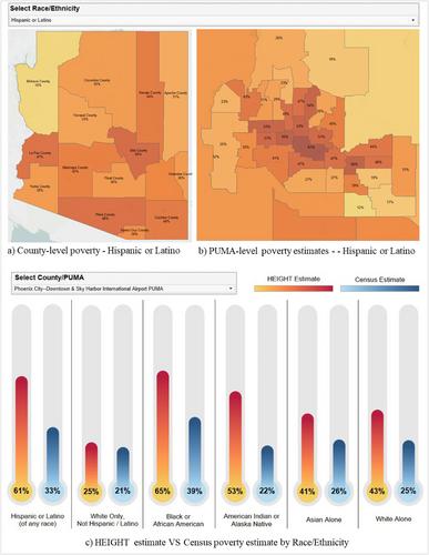
Nearly 38 million people in the United States live in poverty. The Census Bureau's official poverty measure significantly undercounts poverty as it solely focuses on a minimum food diet and fails to account for the geographic variations in living costs. This article offers a geographically adaptive framework for combining multidimensional poverty indicators and modeling the locally adjusted costs of food, housing and utilities, healthcare, childcare, transportation, taxes, and other necessities to assess poverty and geographic inequality across neighborhoods and population sub-groups. We employ a co-design approach for developing the poverty assessment framework and evaluating the results with end users to ensure that communities can build trust and a sense of ownership that enhances the usability and actionability of poverty data. The datasets, quantitative frameworks, and algorithms were woven into an interactive geospatial dashboard toolkit for seamlessly integrating, cleaning, standardizing, and visually communicating the poverty metrics with a broad range of users. Results from this paper advance spatial data analyses and reproducible spatial model-building methods that enable researchers to gain higher resolution, context-specific, and geographically dynamic knowledge of poverty and inequalities.
期刊介绍:
First in its specialty area and one of the most frequently cited publications in geography, Geographical Analysis has, since 1969, presented significant advances in geographical theory, model building, and quantitative methods to geographers and scholars in a wide spectrum of related fields. Traditionally, mathematical and nonmathematical articulations of geographical theory, and statements and discussions of the analytic paradigm are published in the journal. Spatial data analyses and spatial econometrics and statistics are strongly represented.

 求助内容:
求助内容: 应助结果提醒方式:


