Hanna Schroeder, Chen Namimi-Halevi, Osnat Luxenburg, Ayelet Grinbaum Arizon, Zach Tagar, Michal Bromberg, Vered H Eisenberg
{"title":"优化全国范围内透析中心的位置:基于地理信息系统的方法,以提高医疗保健的可及性和可用性。","authors":"Hanna Schroeder, Chen Namimi-Halevi, Osnat Luxenburg, Ayelet Grinbaum Arizon, Zach Tagar, Michal Bromberg, Vered H Eisenberg","doi":"10.1186/s13584-025-00704-5","DOIUrl":null,"url":null,"abstract":"<p><strong>Background: </strong>Accessibility and availability are critical components of quality healthcare, particularly for dialysis patients requiring tri-weekly treatments. Inconveniently placed or oversubscribed dialysis centers contribute to widening healthcare disparities. This study aims to enhance equity in dialysis care by utilizing Geographic Information Systems (GIS) to optimize facility placement through data-driven decision-making.</p><p><strong>Methods: </strong>This cross-sectional study analyzed national data from 5,961 hemodialysis patients across 76 dialysis centers in Israel. Geographic accessibility was assessed using GIS to measure travel distances between patients' residences and their treating dialysis centers. For utilization rate, active hemodialysis patient count was compared to estimated maximum capacity for each center. Statistical comparisons across districts were conducted using chi-square, ANOVA, or Kruskal-Wallis tests, with Bonferroni corrections. Findings were visualized using ArcGIS software.</p><p><strong>Results: </strong>The median travel distance to dialysis centers varied significantly by district (p < 0.001), with the longest distance in the North district (10.9 km) and the shortest in the South district (3.4 km). The mean utilization rate was 73.3%, with the highest in the North district (82.5%) and the lowest in the Jerusalem district (64.3%). No significant differences in utilization rates were found between districts (p = 0.38.</p><p><strong>Conclusions: </strong>To our knowledge, this is the first study to apply GIS to national patient-based data for assessing dialysis center accessibility and utilization. Our findings demonstrate how GIS integration with national registries can inform equitable healthcare planning and facility allocation. This approach offers policymakers a scalable, technology-driven strategy to optimize resource distribution, correct healthcare inequities, and improve accessibility for dialysis patients.</p>","PeriodicalId":46694,"journal":{"name":"Israel Journal of Health Policy Research","volume":"14 1","pages":"40"},"PeriodicalIF":2.2000,"publicationDate":"2025-07-15","publicationTypes":"Journal Article","fieldsOfStudy":null,"isOpenAccess":false,"openAccessPdf":"https://www.ncbi.nlm.nih.gov/pmc/articles/PMC12261728/pdf/","citationCount":"0","resultStr":"{\"title\":\"Optimizing nation-wide locations of dialysis centers: a geographic information system-based approach to improve healthcare accessibility and availability.\",\"authors\":\"Hanna Schroeder, Chen Namimi-Halevi, Osnat Luxenburg, Ayelet Grinbaum Arizon, Zach Tagar, Michal Bromberg, Vered H Eisenberg\",\"doi\":\"10.1186/s13584-025-00704-5\",\"DOIUrl\":null,\"url\":null,\"abstract\":\"<p><strong>Background: </strong>Accessibility and availability are critical components of quality healthcare, particularly for dialysis patients requiring tri-weekly treatments. Inconveniently placed or oversubscribed dialysis centers contribute to widening healthcare disparities. This study aims to enhance equity in dialysis care by utilizing Geographic Information Systems (GIS) to optimize facility placement through data-driven decision-making.</p><p><strong>Methods: </strong>This cross-sectional study analyzed national data from 5,961 hemodialysis patients across 76 dialysis centers in Israel. Geographic accessibility was assessed using GIS to measure travel distances between patients' residences and their treating dialysis centers. For utilization rate, active hemodialysis patient count was compared to estimated maximum capacity for each center. Statistical comparisons across districts were conducted using chi-square, ANOVA, or Kruskal-Wallis tests, with Bonferroni corrections. Findings were visualized using ArcGIS software.</p><p><strong>Results: </strong>The median travel distance to dialysis centers varied significantly by district (p < 0.001), with the longest distance in the North district (10.9 km) and the shortest in the South district (3.4 km). The mean utilization rate was 73.3%, with the highest in the North district (82.5%) and the lowest in the Jerusalem district (64.3%). No significant differences in utilization rates were found between districts (p = 0.38.</p><p><strong>Conclusions: </strong>To our knowledge, this is the first study to apply GIS to national patient-based data for assessing dialysis center accessibility and utilization. Our findings demonstrate how GIS integration with national registries can inform equitable healthcare planning and facility allocation. This approach offers policymakers a scalable, technology-driven strategy to optimize resource distribution, correct healthcare inequities, and improve accessibility for dialysis patients.</p>\",\"PeriodicalId\":46694,\"journal\":{\"name\":\"Israel Journal of Health Policy Research\",\"volume\":\"14 1\",\"pages\":\"40\"},\"PeriodicalIF\":2.2000,\"publicationDate\":\"2025-07-15\",\"publicationTypes\":\"Journal Article\",\"fieldsOfStudy\":null,\"isOpenAccess\":false,\"openAccessPdf\":\"https://www.ncbi.nlm.nih.gov/pmc/articles/PMC12261728/pdf/\",\"citationCount\":\"0\",\"resultStr\":null,\"platform\":\"Semanticscholar\",\"paperid\":null,\"PeriodicalName\":\"Israel Journal of Health Policy Research\",\"FirstCategoryId\":\"3\",\"ListUrlMain\":\"https://doi.org/10.1186/s13584-025-00704-5\",\"RegionNum\":4,\"RegionCategory\":\"医学\",\"ArticlePicture\":[],\"TitleCN\":null,\"AbstractTextCN\":null,\"PMCID\":null,\"EPubDate\":\"\",\"PubModel\":\"\",\"JCR\":\"Q1\",\"JCRName\":\"HEALTH POLICY & SERVICES\",\"Score\":null,\"Total\":0}","platform":"Semanticscholar","paperid":null,"PeriodicalName":"Israel Journal of Health Policy Research","FirstCategoryId":"3","ListUrlMain":"https://doi.org/10.1186/s13584-025-00704-5","RegionNum":4,"RegionCategory":"医学","ArticlePicture":[],"TitleCN":null,"AbstractTextCN":null,"PMCID":null,"EPubDate":"","PubModel":"","JCR":"Q1","JCRName":"HEALTH POLICY & SERVICES","Score":null,"Total":0}
Optimizing nation-wide locations of dialysis centers: a geographic information system-based approach to improve healthcare accessibility and availability.
Background: Accessibility and availability are critical components of quality healthcare, particularly for dialysis patients requiring tri-weekly treatments. Inconveniently placed or oversubscribed dialysis centers contribute to widening healthcare disparities. This study aims to enhance equity in dialysis care by utilizing Geographic Information Systems (GIS) to optimize facility placement through data-driven decision-making.
Methods: This cross-sectional study analyzed national data from 5,961 hemodialysis patients across 76 dialysis centers in Israel. Geographic accessibility was assessed using GIS to measure travel distances between patients' residences and their treating dialysis centers. For utilization rate, active hemodialysis patient count was compared to estimated maximum capacity for each center. Statistical comparisons across districts were conducted using chi-square, ANOVA, or Kruskal-Wallis tests, with Bonferroni corrections. Findings were visualized using ArcGIS software.
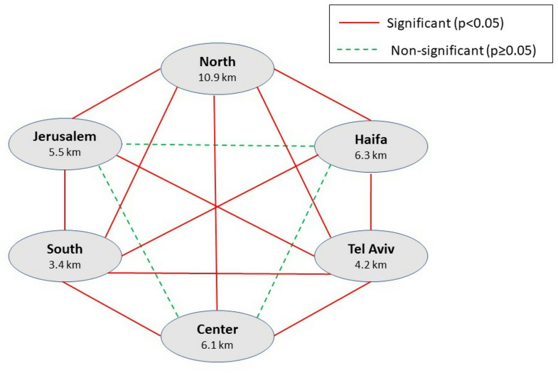
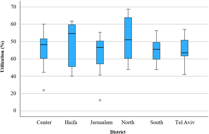
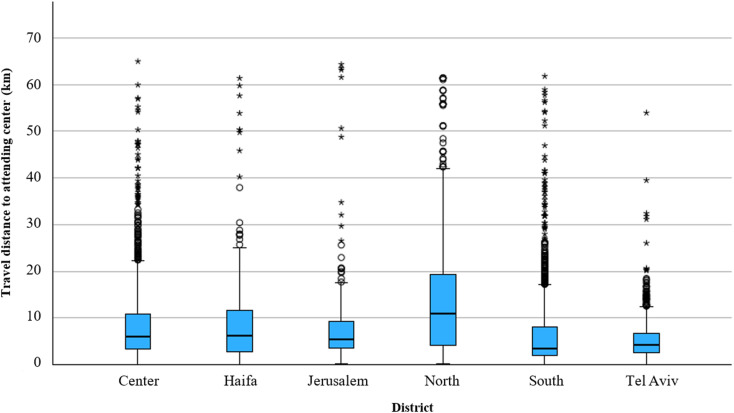
Results: The median travel distance to dialysis centers varied significantly by district (p < 0.001), with the longest distance in the North district (10.9 km) and the shortest in the South district (3.4 km). The mean utilization rate was 73.3%, with the highest in the North district (82.5%) and the lowest in the Jerusalem district (64.3%). No significant differences in utilization rates were found between districts (p = 0.38.
Conclusions: To our knowledge, this is the first study to apply GIS to national patient-based data for assessing dialysis center accessibility and utilization. Our findings demonstrate how GIS integration with national registries can inform equitable healthcare planning and facility allocation. This approach offers policymakers a scalable, technology-driven strategy to optimize resource distribution, correct healthcare inequities, and improve accessibility for dialysis patients.

 求助内容:
求助内容: 应助结果提醒方式:


