大都市蚊密度地理空间可解释人工智能(GeoXAI)框架的开发与验证

IF 5.4 2区 地球科学 Q1 GEOGRAPHY
Xu Guang , Lanbin Xiang , Yifei He , Ning Zhang , Junyao Zheng , Yanmin Qin , Dongfeng Kong , Haidong Wang , Liangqiang Lin , Bin Zhu
{"title":"大都市蚊密度地理空间可解释人工智能(GeoXAI)框架的开发与验证","authors":"Xu Guang ,&nbsp;Lanbin Xiang ,&nbsp;Yifei He ,&nbsp;Ning Zhang ,&nbsp;Junyao Zheng ,&nbsp;Yanmin Qin ,&nbsp;Dongfeng Kong ,&nbsp;Haidong Wang ,&nbsp;Liangqiang Lin ,&nbsp;Bin Zhu","doi":"10.1016/j.apgeog.2025.103685","DOIUrl":null,"url":null,"abstract":"<div><div>Accurately predicting mosquito density in metropolitans is challenging due to the nonlinear, spatially non-stationary relationships between explanatory variables and <em>in situ</em> monitoring data. These challenges are further exacerbated by the limited interpretability of traditional statistical and artificial intelligence models. To overcome existing limitations, we integrated the Shapley additive explanation (SHAP) method and geographically neural network weighted regression kriging (GNNWRK) model to develop the GNNWRK-SHAP framework for predicting mosquito density in Shenzhen and Central Guangzhou (C-Guangzhou), China. GNNWR is an enhanced spatial model derived from GWR, which combines ordinary least squares and spatial weighted neural network to capture spatial non-stationarity and complex nonlinearity. Our results demonstrated that the GNNWRK-SHAP framework achieved the lowest mean absolute error (1.72 in Shenzhen, 3.22 in C-Guangzhou), root mean square error (2.05 &amp; 3.76), and mean absolute percentage error (42.48 % &amp; 62.95 %) compared to alternative models. By integrating the SHAP, the framework quantified variable contributions, identifying precipitation and temperature as dominant explanatory variables shaping mosquito distributions. Moreover, spatial SHAP values highlighted the spatially varying impacts of these, offering site-specific decision support for mosquito density control. This study provides a novel framework for high-precision mapping while maintaining spatial interpretability, providing new insights for mosquito monitoring and management.</div></div>","PeriodicalId":48396,"journal":{"name":"Applied Geography","volume":"181 ","pages":"Article 103685"},"PeriodicalIF":5.4000,"publicationDate":"2025-06-24","publicationTypes":"Journal Article","fieldsOfStudy":null,"isOpenAccess":false,"openAccessPdf":"","citationCount":"0","resultStr":"{\"title\":\"Development and validation of a Geospatial eXplainable Artificial Intelligence (GeoXAI) framework for mapping mosquito density in metropolitans\",\"authors\":\"Xu Guang ,&nbsp;Lanbin Xiang ,&nbsp;Yifei He ,&nbsp;Ning Zhang ,&nbsp;Junyao Zheng ,&nbsp;Yanmin Qin ,&nbsp;Dongfeng Kong ,&nbsp;Haidong Wang ,&nbsp;Liangqiang Lin ,&nbsp;Bin Zhu\",\"doi\":\"10.1016/j.apgeog.2025.103685\",\"DOIUrl\":null,\"url\":null,\"abstract\":\"<div><div>Accurately predicting mosquito density in metropolitans is challenging due to the nonlinear, spatially non-stationary relationships between explanatory variables and <em>in situ</em> monitoring data. These challenges are further exacerbated by the limited interpretability of traditional statistical and artificial intelligence models. To overcome existing limitations, we integrated the Shapley additive explanation (SHAP) method and geographically neural network weighted regression kriging (GNNWRK) model to develop the GNNWRK-SHAP framework for predicting mosquito density in Shenzhen and Central Guangzhou (C-Guangzhou), China. GNNWR is an enhanced spatial model derived from GWR, which combines ordinary least squares and spatial weighted neural network to capture spatial non-stationarity and complex nonlinearity. Our results demonstrated that the GNNWRK-SHAP framework achieved the lowest mean absolute error (1.72 in Shenzhen, 3.22 in C-Guangzhou), root mean square error (2.05 &amp; 3.76), and mean absolute percentage error (42.48 % &amp; 62.95 %) compared to alternative models. By integrating the SHAP, the framework quantified variable contributions, identifying precipitation and temperature as dominant explanatory variables shaping mosquito distributions. Moreover, spatial SHAP values highlighted the spatially varying impacts of these, offering site-specific decision support for mosquito density control. This study provides a novel framework for high-precision mapping while maintaining spatial interpretability, providing new insights for mosquito monitoring and management.</div></div>\",\"PeriodicalId\":48396,\"journal\":{\"name\":\"Applied Geography\",\"volume\":\"181 \",\"pages\":\"Article 103685\"},\"PeriodicalIF\":5.4000,\"publicationDate\":\"2025-06-24\",\"publicationTypes\":\"Journal Article\",\"fieldsOfStudy\":null,\"isOpenAccess\":false,\"openAccessPdf\":\"\",\"citationCount\":\"0\",\"resultStr\":null,\"platform\":\"Semanticscholar\",\"paperid\":null,\"PeriodicalName\":\"Applied Geography\",\"FirstCategoryId\":\"89\",\"ListUrlMain\":\"https://www.sciencedirect.com/science/article/pii/S0143622825001808\",\"RegionNum\":2,\"RegionCategory\":\"地球科学\",\"ArticlePicture\":[],\"TitleCN\":null,\"AbstractTextCN\":null,\"PMCID\":null,\"EPubDate\":\"\",\"PubModel\":\"\",\"JCR\":\"Q1\",\"JCRName\":\"GEOGRAPHY\",\"Score\":null,\"Total\":0}","platform":"Semanticscholar","paperid":null,"PeriodicalName":"Applied Geography","FirstCategoryId":"89","ListUrlMain":"https://www.sciencedirect.com/science/article/pii/S0143622825001808","RegionNum":2,"RegionCategory":"地球科学","ArticlePicture":[],"TitleCN":null,"AbstractTextCN":null,"PMCID":null,"EPubDate":"","PubModel":"","JCR":"Q1","JCRName":"GEOGRAPHY","Score":null,"Total":0}
引用次数: 0

摘要

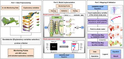
由于解释变量与现场监测数据之间的非线性、空间非平稳关系,准确预测大都市蚊子密度具有挑战性。传统统计和人工智能模型的有限可解释性进一步加剧了这些挑战。为克服现有的局限性,将Shapley加性解释(SHAP)方法与地理神经网络加权回归克里格(GNNWRK)模型相结合,建立了用于深圳和中广州蚊密度预测的GNNWRK-SHAP框架。GNNWR是在GWR基础上改进的空间模型,将普通最小二乘和空间加权神经网络相结合,捕捉空间非平稳性和复杂非线性。结果表明,GNNWRK-SHAP框架的平均绝对误差最低(深圳1.72,广州3.22),均方根误差最低(2.05 &;3.76),平均绝对百分比误差(42.48% &;62.95%)。通过整合SHAP,该框架量化了变量贡献,确定降水和温度是影响蚊子分布的主要解释变量。此外,空间SHAP值突出了这些影响的空间差异,为蚊密度控制提供了特定地点的决策支持。该研究提供了一种新的高精度制图框架,同时保持了空间可解释性,为蚊虫监测和管理提供了新的见解。
本文章由计算机程序翻译,如有差异,请以英文原文为准。

Development and validation of a Geospatial eXplainable Artificial Intelligence (GeoXAI) framework for mapping mosquito density in metropolitans

Development and validation of a Geospatial eXplainable Artificial Intelligence (GeoXAI) framework for mapping mosquito density in metropolitans
Accurately predicting mosquito density in metropolitans is challenging due to the nonlinear, spatially non-stationary relationships between explanatory variables and in situ monitoring data. These challenges are further exacerbated by the limited interpretability of traditional statistical and artificial intelligence models. To overcome existing limitations, we integrated the Shapley additive explanation (SHAP) method and geographically neural network weighted regression kriging (GNNWRK) model to develop the GNNWRK-SHAP framework for predicting mosquito density in Shenzhen and Central Guangzhou (C-Guangzhou), China. GNNWR is an enhanced spatial model derived from GWR, which combines ordinary least squares and spatial weighted neural network to capture spatial non-stationarity and complex nonlinearity. Our results demonstrated that the GNNWRK-SHAP framework achieved the lowest mean absolute error (1.72 in Shenzhen, 3.22 in C-Guangzhou), root mean square error (2.05 & 3.76), and mean absolute percentage error (42.48 % & 62.95 %) compared to alternative models. By integrating the SHAP, the framework quantified variable contributions, identifying precipitation and temperature as dominant explanatory variables shaping mosquito distributions. Moreover, spatial SHAP values highlighted the spatially varying impacts of these, offering site-specific decision support for mosquito density control. This study provides a novel framework for high-precision mapping while maintaining spatial interpretability, providing new insights for mosquito monitoring and management.
求助全文
通过发布文献求助,成功后即可免费获取论文全文。 去求助
来源期刊
Applied Geography
Applied Geography GEOGRAPHY-
CiteScore
8.00
自引率
2.00%
发文量
134
期刊介绍: Applied Geography is a journal devoted to the publication of research which utilizes geographic approaches (human, physical, nature-society and GIScience) to resolve human problems that have a spatial dimension. These problems may be related to the assessment, management and allocation of the world physical and/or human resources. The underlying rationale of the journal is that only through a clear understanding of the relevant societal, physical, and coupled natural-humans systems can we resolve such problems. Papers are invited on any theme involving the application of geographical theory and methodology in the resolution of human problems.
×
引用
GB/T 7714-2015
复制
MLA
复制
APA
复制
导出至
BibTeX EndNote RefMan NoteFirst NoteExpress
×
提示
您的信息不完整,为了账户安全,请先补充。
现在去补充
×
提示
您因"违规操作"
具体请查看互助需知
我知道了
×
提示
确定
请完成安全验证×
copy
已复制链接
快去分享给好友吧!
我知道了
右上角分享
点击右上角分享
0
联系我们:info@booksci.cn Book学术提供免费学术资源搜索服务,方便国内外学者检索中英文文献。致力于提供最便捷和优质的服务体验。 Copyright © 2023 布克学术 All rights reserved.
京ICP备2023020795号-1
ghs 京公网安备 11010802042870号
Book学术文献互助
Book学术文献互助群
群 号:604180095
Book学术官方微信