M. V. S. Ramarao, Ashish Routray, Devajyoti Dutta, Srinivas Desamsetti, John P. George, V. S. Prasad
{"title":"SMAP卫星土壤水分反演同化对印度高分辨率区域土地数据同化系统的影响","authors":"M. V. S. Ramarao, Ashish Routray, Devajyoti Dutta, Srinivas Desamsetti, John P. George, V. S. Prasad","doi":"10.1002/met.70049","DOIUrl":null,"url":null,"abstract":"<p>Soil moisture (SM) is one of the crucial variables of the earth system that needs to be accurately initialized in a numerical weather model for accurate weather predictions. As the availability of in situ SM observations is sparse in space and time, satellite-derived SM estimates are widely used to create model surface boundary conditions through assimilation techniques. SM retrievals from the soil moisture active passive (SMAP) satellite have been assimilated into the high-resolution NCUM-R operational forecasting system over the Indian region for the first time in this study. The simplified extended Kalman filter (sEKF) based Land Data Assimilation System (LDAS) creates land surface SM initial conditions for NCUM-R by assimilating SMAP-derived SM and screen-level observations. Two numerical experiments, namely CTL (incorporating only screen level observations in LDAS) and SMP (assimilating both SMAP SM and screen level observations in LDAS), are carried out to assess the model's forecast skill improvement by assimilating SM. The validation analysis with the SM in situ observations network indicates skill improvement of 0.013 and 0.002 for anomaly correlation and unbiased RMSE in the accuracy of SM estimates with assimilation. The skill improvement is found to be higher in the wetter SM regions. Furthermore, the positive impact of SM assimilation on the forecast of surface air temperature is also noted. Finally, we demonstrated that the SMAP assimilation has led to a more realistic representation of SM than in the control simulation for various precipitation events, suggesting its usage for drought/flood monitoring in the long term.</p>","PeriodicalId":49825,"journal":{"name":"Meteorological Applications","volume":"32 3","pages":""},"PeriodicalIF":2.5000,"publicationDate":"2025-06-09","publicationTypes":"Journal Article","fieldsOfStudy":null,"isOpenAccess":false,"openAccessPdf":"https://onlinelibrary.wiley.com/doi/epdf/10.1002/met.70049","citationCount":"0","resultStr":"{\"title\":\"Impact of Assimilation of SMAP Satellite Soil Moisture Retrievals Into a High-Resolution Regional Land Data Assimilation System Over India\",\"authors\":\"M. V. S. Ramarao, Ashish Routray, Devajyoti Dutta, Srinivas Desamsetti, John P. George, V. S. Prasad\",\"doi\":\"10.1002/met.70049\",\"DOIUrl\":null,\"url\":null,\"abstract\":\"<p>Soil moisture (SM) is one of the crucial variables of the earth system that needs to be accurately initialized in a numerical weather model for accurate weather predictions. As the availability of in situ SM observations is sparse in space and time, satellite-derived SM estimates are widely used to create model surface boundary conditions through assimilation techniques. SM retrievals from the soil moisture active passive (SMAP) satellite have been assimilated into the high-resolution NCUM-R operational forecasting system over the Indian region for the first time in this study. The simplified extended Kalman filter (sEKF) based Land Data Assimilation System (LDAS) creates land surface SM initial conditions for NCUM-R by assimilating SMAP-derived SM and screen-level observations. Two numerical experiments, namely CTL (incorporating only screen level observations in LDAS) and SMP (assimilating both SMAP SM and screen level observations in LDAS), are carried out to assess the model's forecast skill improvement by assimilating SM. The validation analysis with the SM in situ observations network indicates skill improvement of 0.013 and 0.002 for anomaly correlation and unbiased RMSE in the accuracy of SM estimates with assimilation. The skill improvement is found to be higher in the wetter SM regions. Furthermore, the positive impact of SM assimilation on the forecast of surface air temperature is also noted. Finally, we demonstrated that the SMAP assimilation has led to a more realistic representation of SM than in the control simulation for various precipitation events, suggesting its usage for drought/flood monitoring in the long term.</p>\",\"PeriodicalId\":49825,\"journal\":{\"name\":\"Meteorological Applications\",\"volume\":\"32 3\",\"pages\":\"\"},\"PeriodicalIF\":2.5000,\"publicationDate\":\"2025-06-09\",\"publicationTypes\":\"Journal Article\",\"fieldsOfStudy\":null,\"isOpenAccess\":false,\"openAccessPdf\":\"https://onlinelibrary.wiley.com/doi/epdf/10.1002/met.70049\",\"citationCount\":\"0\",\"resultStr\":null,\"platform\":\"Semanticscholar\",\"paperid\":null,\"PeriodicalName\":\"Meteorological Applications\",\"FirstCategoryId\":\"89\",\"ListUrlMain\":\"https://rmets.onlinelibrary.wiley.com/doi/10.1002/met.70049\",\"RegionNum\":4,\"RegionCategory\":\"地球科学\",\"ArticlePicture\":[],\"TitleCN\":null,\"AbstractTextCN\":null,\"PMCID\":null,\"EPubDate\":\"\",\"PubModel\":\"\",\"JCR\":\"Q3\",\"JCRName\":\"METEOROLOGY & ATMOSPHERIC SCIENCES\",\"Score\":null,\"Total\":0}","platform":"Semanticscholar","paperid":null,"PeriodicalName":"Meteorological Applications","FirstCategoryId":"89","ListUrlMain":"https://rmets.onlinelibrary.wiley.com/doi/10.1002/met.70049","RegionNum":4,"RegionCategory":"地球科学","ArticlePicture":[],"TitleCN":null,"AbstractTextCN":null,"PMCID":null,"EPubDate":"","PubModel":"","JCR":"Q3","JCRName":"METEOROLOGY & ATMOSPHERIC SCIENCES","Score":null,"Total":0}
Impact of Assimilation of SMAP Satellite Soil Moisture Retrievals Into a High-Resolution Regional Land Data Assimilation System Over India
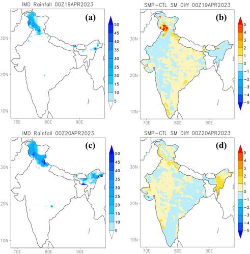
Soil moisture (SM) is one of the crucial variables of the earth system that needs to be accurately initialized in a numerical weather model for accurate weather predictions. As the availability of in situ SM observations is sparse in space and time, satellite-derived SM estimates are widely used to create model surface boundary conditions through assimilation techniques. SM retrievals from the soil moisture active passive (SMAP) satellite have been assimilated into the high-resolution NCUM-R operational forecasting system over the Indian region for the first time in this study. The simplified extended Kalman filter (sEKF) based Land Data Assimilation System (LDAS) creates land surface SM initial conditions for NCUM-R by assimilating SMAP-derived SM and screen-level observations. Two numerical experiments, namely CTL (incorporating only screen level observations in LDAS) and SMP (assimilating both SMAP SM and screen level observations in LDAS), are carried out to assess the model's forecast skill improvement by assimilating SM. The validation analysis with the SM in situ observations network indicates skill improvement of 0.013 and 0.002 for anomaly correlation and unbiased RMSE in the accuracy of SM estimates with assimilation. The skill improvement is found to be higher in the wetter SM regions. Furthermore, the positive impact of SM assimilation on the forecast of surface air temperature is also noted. Finally, we demonstrated that the SMAP assimilation has led to a more realistic representation of SM than in the control simulation for various precipitation events, suggesting its usage for drought/flood monitoring in the long term.
期刊介绍:
The aim of Meteorological Applications is to serve the needs of applied meteorologists, forecasters and users of meteorological services by publishing papers on all aspects of meteorological science, including:
applications of meteorological, climatological, analytical and forecasting data, and their socio-economic benefits;
forecasting, warning and service delivery techniques and methods;
weather hazards, their analysis and prediction;
performance, verification and value of numerical models and forecasting services;
practical applications of ocean and climate models;
education and training.


 求助内容:
求助内容: 应助结果提醒方式:


