Patrick K. Kalonde, Taonga Mwapasa, Rosheen Mthawanji, Kondwani Chidziwisano, Tracy Morse, Jeffrey S. Torguson, Christopher M. Jones, Richard S. Quilliam, Nicholas A. Feasey, Marc Y. R. Henrion, Michelle C. Stanton, Mikhail S. Blinnikov
{"title":"利用地面调查、无人机图像的人工数字化和基于目标的图像分类方法绘制城市环境中的废物堆","authors":"Patrick K. Kalonde, Taonga Mwapasa, Rosheen Mthawanji, Kondwani Chidziwisano, Tracy Morse, Jeffrey S. Torguson, Christopher M. Jones, Richard S. Quilliam, Nicholas A. Feasey, Marc Y. R. Henrion, Michelle C. Stanton, Mikhail S. Blinnikov","doi":"10.1007/s10661-025-13675-6","DOIUrl":null,"url":null,"abstract":"<div><p>There is wide recognition of the threats posed by the open dumping of waste in the environment. However, tools to surveil interventions for reducing this practice are poorly developed. This study explores the use of drone imagery for environmental surveillance. Drone images of waste piles were captured in a densely populated residential neighborhood in the Republic of Malawi. Images were processed using the Structure for Motion (SfM) technique and partitioned into segments using Orfeo Toolbox mounted in QGIS software. A total of 509 segments were manually labeled to generate data for training and testing a series of classification models. Four supervised classification algorithms (Random Forest, Artificial Neural Network, Naïve Bayes, and Support Vector Machine) were trained, and their performances were assessed regarding precision, recall, and F-1 score. Ground surveys were also conducted to map waste piles using a Global Positioning System (GPS) receiver and determine the physical composition of materials on the waste pile surface. Differences were observed between the field survey done by community-led physical mapping of waste piles and drone mapping. Drone mapping identified more waste piles than field surveys, and the spatial extent of waste piles was computed for each waste pile. The binary Support Vector Machine model predictions were the highest performing, with a precision of 0.98, recall of 0.99, and F1-score of 0.98. Drone mapping enabled the identification of waste piles in areas that cannot be accessed during ground surveys and further allowed the quantification of the total land surface area covered by waste piles. Drone imagery-based surveillance of waste piles thus has the potential to guide environmental waste policy, offer solutions for permanent monitoring, and evaluate waste reduction interventions.</p></div>","PeriodicalId":544,"journal":{"name":"Environmental Monitoring and Assessment","volume":"197 4","pages":""},"PeriodicalIF":3.0000,"publicationDate":"2025-03-11","publicationTypes":"Journal Article","fieldsOfStudy":null,"isOpenAccess":false,"openAccessPdf":"","citationCount":"0","resultStr":"{\"title\":\"Mapping waste piles in an urban environment using ground surveys, manual digitization of drone imagery, and object based image classification approach\",\"authors\":\"Patrick K. Kalonde, Taonga Mwapasa, Rosheen Mthawanji, Kondwani Chidziwisano, Tracy Morse, Jeffrey S. Torguson, Christopher M. Jones, Richard S. Quilliam, Nicholas A. Feasey, Marc Y. R. Henrion, Michelle C. Stanton, Mikhail S. Blinnikov\",\"doi\":\"10.1007/s10661-025-13675-6\",\"DOIUrl\":null,\"url\":null,\"abstract\":\"<div><p>There is wide recognition of the threats posed by the open dumping of waste in the environment. However, tools to surveil interventions for reducing this practice are poorly developed. This study explores the use of drone imagery for environmental surveillance. Drone images of waste piles were captured in a densely populated residential neighborhood in the Republic of Malawi. Images were processed using the Structure for Motion (SfM) technique and partitioned into segments using Orfeo Toolbox mounted in QGIS software. A total of 509 segments were manually labeled to generate data for training and testing a series of classification models. Four supervised classification algorithms (Random Forest, Artificial Neural Network, Naïve Bayes, and Support Vector Machine) were trained, and their performances were assessed regarding precision, recall, and F-1 score. Ground surveys were also conducted to map waste piles using a Global Positioning System (GPS) receiver and determine the physical composition of materials on the waste pile surface. Differences were observed between the field survey done by community-led physical mapping of waste piles and drone mapping. Drone mapping identified more waste piles than field surveys, and the spatial extent of waste piles was computed for each waste pile. The binary Support Vector Machine model predictions were the highest performing, with a precision of 0.98, recall of 0.99, and F1-score of 0.98. Drone mapping enabled the identification of waste piles in areas that cannot be accessed during ground surveys and further allowed the quantification of the total land surface area covered by waste piles. Drone imagery-based surveillance of waste piles thus has the potential to guide environmental waste policy, offer solutions for permanent monitoring, and evaluate waste reduction interventions.</p></div>\",\"PeriodicalId\":544,\"journal\":{\"name\":\"Environmental Monitoring and Assessment\",\"volume\":\"197 4\",\"pages\":\"\"},\"PeriodicalIF\":3.0000,\"publicationDate\":\"2025-03-11\",\"publicationTypes\":\"Journal Article\",\"fieldsOfStudy\":null,\"isOpenAccess\":false,\"openAccessPdf\":\"\",\"citationCount\":\"0\",\"resultStr\":null,\"platform\":\"Semanticscholar\",\"paperid\":null,\"PeriodicalName\":\"Environmental Monitoring and Assessment\",\"FirstCategoryId\":\"93\",\"ListUrlMain\":\"https://link.springer.com/article/10.1007/s10661-025-13675-6\",\"RegionNum\":4,\"RegionCategory\":\"环境科学与生态学\",\"ArticlePicture\":[],\"TitleCN\":null,\"AbstractTextCN\":null,\"PMCID\":null,\"EPubDate\":\"\",\"PubModel\":\"\",\"JCR\":\"Q3\",\"JCRName\":\"ENVIRONMENTAL SCIENCES\",\"Score\":null,\"Total\":0}","platform":"Semanticscholar","paperid":null,"PeriodicalName":"Environmental Monitoring and Assessment","FirstCategoryId":"93","ListUrlMain":"https://link.springer.com/article/10.1007/s10661-025-13675-6","RegionNum":4,"RegionCategory":"环境科学与生态学","ArticlePicture":[],"TitleCN":null,"AbstractTextCN":null,"PMCID":null,"EPubDate":"","PubModel":"","JCR":"Q3","JCRName":"ENVIRONMENTAL SCIENCES","Score":null,"Total":0}
Mapping waste piles in an urban environment using ground surveys, manual digitization of drone imagery, and object based image classification approach
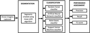
There is wide recognition of the threats posed by the open dumping of waste in the environment. However, tools to surveil interventions for reducing this practice are poorly developed. This study explores the use of drone imagery for environmental surveillance. Drone images of waste piles were captured in a densely populated residential neighborhood in the Republic of Malawi. Images were processed using the Structure for Motion (SfM) technique and partitioned into segments using Orfeo Toolbox mounted in QGIS software. A total of 509 segments were manually labeled to generate data for training and testing a series of classification models. Four supervised classification algorithms (Random Forest, Artificial Neural Network, Naïve Bayes, and Support Vector Machine) were trained, and their performances were assessed regarding precision, recall, and F-1 score. Ground surveys were also conducted to map waste piles using a Global Positioning System (GPS) receiver and determine the physical composition of materials on the waste pile surface. Differences were observed between the field survey done by community-led physical mapping of waste piles and drone mapping. Drone mapping identified more waste piles than field surveys, and the spatial extent of waste piles was computed for each waste pile. The binary Support Vector Machine model predictions were the highest performing, with a precision of 0.98, recall of 0.99, and F1-score of 0.98. Drone mapping enabled the identification of waste piles in areas that cannot be accessed during ground surveys and further allowed the quantification of the total land surface area covered by waste piles. Drone imagery-based surveillance of waste piles thus has the potential to guide environmental waste policy, offer solutions for permanent monitoring, and evaluate waste reduction interventions.
期刊介绍:
Environmental Monitoring and Assessment emphasizes technical developments and data arising from environmental monitoring and assessment, the use of scientific principles in the design of monitoring systems at the local, regional and global scales, and the use of monitoring data in assessing the consequences of natural resource management actions and pollution risks to man and the environment.

 求助内容:
求助内容: 应助结果提醒方式:


