{"title":"遥感在生态研究中的意义——从像素到保护","authors":"Luca Luiselli, Nic Pacini","doi":"10.1111/aje.70002","DOIUrl":null,"url":null,"abstract":"<p>Advances in analytical techniques and the development of innovative remote sensing tools have greatly broadened the scope of ecological research. These advancements have led to notable progress in understanding the geography of study areas, with ground-truthing capabilities enabled by GPS technologies revolutionising the generation of precise spatial data, such as organism locations. By linking spatial data with modelling, researchers can now gain insights into species-environment relationships. This informs conservation strategies and resource management. Recent technological innovations, including as high-resolution satellites provide detailed spatial and temporal information. The rapid growth of these technologies presents transformative opportunities for ecological research and biodiversity conservation anywhere in the world. Moreover, calibration via field-based spectral data, unmanned aerial vehicles (UAVs), and handheld global positioning systems (GPS) ensures signal accuracy and integrative platforms, like Google Earth Engine, streamline data interpretation. However, integrating evidence from these diverse systems presents ongoing challenges, requiring methodological precision and a clear focus on their ecological relevance. The <i>African Journal of Ecology</i> (AJE) has increasingly featured studies using remote sensing, with applications spanning studies focusing on land-use change detection, habitat surveys, vegetation biomass assessment, water resource monitoring, and species distribution. Combining remote sensing with field methods and ecological objectives fosters robust analysis, enabling researchers to move beyond simple land cover assessments to tackle functional ecological questions. Integrative platforms like Google Earth Engine simplify multi-source data interpretation, streamlining workflows and increasing accessibility. The Latin phrase ‘<i>Memento mori</i>’ should serve as a reminder that technology, while a powerful aid in ecological research, is not everything—it should serve to support and enhance ecological inquiry, not define or overshadow it. The AJE aspires to promote such reflective thinking, fostering a balance between innovation and ecological relevance.</p>","PeriodicalId":7844,"journal":{"name":"African Journal of Ecology","volume":"63 1","pages":""},"PeriodicalIF":1.1000,"publicationDate":"2025-01-16","publicationTypes":"Journal Article","fieldsOfStudy":null,"isOpenAccess":false,"openAccessPdf":"https://onlinelibrary.wiley.com/doi/epdf/10.1111/aje.70002","citationCount":"0","resultStr":"{\"title\":\"Remote Sensing That Makes Sense in Ecological Research—From Pixels to Conservation\",\"authors\":\"Luca Luiselli, Nic Pacini\",\"doi\":\"10.1111/aje.70002\",\"DOIUrl\":null,\"url\":null,\"abstract\":\"<p>Advances in analytical techniques and the development of innovative remote sensing tools have greatly broadened the scope of ecological research. These advancements have led to notable progress in understanding the geography of study areas, with ground-truthing capabilities enabled by GPS technologies revolutionising the generation of precise spatial data, such as organism locations. By linking spatial data with modelling, researchers can now gain insights into species-environment relationships. This informs conservation strategies and resource management. Recent technological innovations, including as high-resolution satellites provide detailed spatial and temporal information. The rapid growth of these technologies presents transformative opportunities for ecological research and biodiversity conservation anywhere in the world. Moreover, calibration via field-based spectral data, unmanned aerial vehicles (UAVs), and handheld global positioning systems (GPS) ensures signal accuracy and integrative platforms, like Google Earth Engine, streamline data interpretation. However, integrating evidence from these diverse systems presents ongoing challenges, requiring methodological precision and a clear focus on their ecological relevance. The <i>African Journal of Ecology</i> (AJE) has increasingly featured studies using remote sensing, with applications spanning studies focusing on land-use change detection, habitat surveys, vegetation biomass assessment, water resource monitoring, and species distribution. Combining remote sensing with field methods and ecological objectives fosters robust analysis, enabling researchers to move beyond simple land cover assessments to tackle functional ecological questions. Integrative platforms like Google Earth Engine simplify multi-source data interpretation, streamlining workflows and increasing accessibility. The Latin phrase ‘<i>Memento mori</i>’ should serve as a reminder that technology, while a powerful aid in ecological research, is not everything—it should serve to support and enhance ecological inquiry, not define or overshadow it. The AJE aspires to promote such reflective thinking, fostering a balance between innovation and ecological relevance.</p>\",\"PeriodicalId\":7844,\"journal\":{\"name\":\"African Journal of Ecology\",\"volume\":\"63 1\",\"pages\":\"\"},\"PeriodicalIF\":1.1000,\"publicationDate\":\"2025-01-16\",\"publicationTypes\":\"Journal Article\",\"fieldsOfStudy\":null,\"isOpenAccess\":false,\"openAccessPdf\":\"https://onlinelibrary.wiley.com/doi/epdf/10.1111/aje.70002\",\"citationCount\":\"0\",\"resultStr\":null,\"platform\":\"Semanticscholar\",\"paperid\":null,\"PeriodicalName\":\"African Journal of Ecology\",\"FirstCategoryId\":\"93\",\"ListUrlMain\":\"https://onlinelibrary.wiley.com/doi/10.1111/aje.70002\",\"RegionNum\":4,\"RegionCategory\":\"环境科学与生态学\",\"ArticlePicture\":[],\"TitleCN\":null,\"AbstractTextCN\":null,\"PMCID\":null,\"EPubDate\":\"\",\"PubModel\":\"\",\"JCR\":\"Q4\",\"JCRName\":\"ECOLOGY\",\"Score\":null,\"Total\":0}","platform":"Semanticscholar","paperid":null,"PeriodicalName":"African Journal of Ecology","FirstCategoryId":"93","ListUrlMain":"https://onlinelibrary.wiley.com/doi/10.1111/aje.70002","RegionNum":4,"RegionCategory":"环境科学与生态学","ArticlePicture":[],"TitleCN":null,"AbstractTextCN":null,"PMCID":null,"EPubDate":"","PubModel":"","JCR":"Q4","JCRName":"ECOLOGY","Score":null,"Total":0}
Remote Sensing That Makes Sense in Ecological Research—From Pixels to Conservation
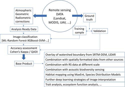
Advances in analytical techniques and the development of innovative remote sensing tools have greatly broadened the scope of ecological research. These advancements have led to notable progress in understanding the geography of study areas, with ground-truthing capabilities enabled by GPS technologies revolutionising the generation of precise spatial data, such as organism locations. By linking spatial data with modelling, researchers can now gain insights into species-environment relationships. This informs conservation strategies and resource management. Recent technological innovations, including as high-resolution satellites provide detailed spatial and temporal information. The rapid growth of these technologies presents transformative opportunities for ecological research and biodiversity conservation anywhere in the world. Moreover, calibration via field-based spectral data, unmanned aerial vehicles (UAVs), and handheld global positioning systems (GPS) ensures signal accuracy and integrative platforms, like Google Earth Engine, streamline data interpretation. However, integrating evidence from these diverse systems presents ongoing challenges, requiring methodological precision and a clear focus on their ecological relevance. The African Journal of Ecology (AJE) has increasingly featured studies using remote sensing, with applications spanning studies focusing on land-use change detection, habitat surveys, vegetation biomass assessment, water resource monitoring, and species distribution. Combining remote sensing with field methods and ecological objectives fosters robust analysis, enabling researchers to move beyond simple land cover assessments to tackle functional ecological questions. Integrative platforms like Google Earth Engine simplify multi-source data interpretation, streamlining workflows and increasing accessibility. The Latin phrase ‘Memento mori’ should serve as a reminder that technology, while a powerful aid in ecological research, is not everything—it should serve to support and enhance ecological inquiry, not define or overshadow it. The AJE aspires to promote such reflective thinking, fostering a balance between innovation and ecological relevance.
期刊介绍:
African Journal of Ecology (formerly East African Wildlife Journal) publishes original scientific research into the ecology and conservation of the animals and plants of Africa. It has a wide circulation both within and outside Africa and is the foremost research journal on the ecology of the continent. In addition to original articles, the Journal publishes comprehensive reviews on topical subjects and brief communications of preliminary results.
 求助内容:
求助内容: 应助结果提醒方式:


