Han Lin, Jun Li, Min Min, Feng Zhang, Keyue Wang, Qunyong Wu
{"title":"CLANN:用于估算地球静止卫星成像仪三维云量的云量神经网络","authors":"Han Lin, Jun Li, Min Min, Feng Zhang, Keyue Wang, Qunyong Wu","doi":"10.1016/j.rse.2025.114600","DOIUrl":null,"url":null,"abstract":"Accurate information on cloud amount vertical structure is crucial for weather monitoring and understanding climate systems. Active sensors from satellites can provide three-dimensional (3D) cloud structure but with limited geographical coverage, passive sensors from satellites have expanded observation coverage but with limited capability on profiling the clouds. Combing active and passive observations from satellites, together with atmospheric reanalysis data, this study proposes a machine learning approach (CLANN, CLoud Amount Neural Network) to construct three-dimensional (3D) cloud amounts at passive observational coverage. Independent validation is conducted for cloud amount estimates derived from combined data of the Advanced Geostationary Radiation Imager (AGRI) onboard Fengyun-4 A and ERA5 using CALIPSO/CALIOP product as reference. The results indicate notable correlations (Pearson's <ce:italic>r</ce:italic> = 0.73). The cloud-amount-weighted height showed a high consistency in terms of height positioning between CLANN estimations and CALIOP data, with an RMSE of 1.88 km and a Pearson's r of 0.92. Key features such as water vapor band brightness temperature and upper-layer temperature significantly enhanced model accuracy, as revealed by permutation importance analysis. Sensitivity tests highlighted the critical role of the 1.375 μm band in cirrus altitude detection, justifying the model's reliance on daytime observations. Additionally, the 3D statistical results from CLANN in 2019 reveal the seasonal variation details of cloud distribution, further demonstrating its application value in climate analysis.","PeriodicalId":417,"journal":{"name":"Remote Sensing of Environment","volume":"23 1","pages":""},"PeriodicalIF":11.1000,"publicationDate":"2025-01-17","publicationTypes":"Journal Article","fieldsOfStudy":null,"isOpenAccess":false,"openAccessPdf":"","citationCount":"0","resultStr":"{\"title\":\"CLANN: Cloud amount neural network for estimating 3D cloud from geostationary satellite imager\",\"authors\":\"Han Lin, Jun Li, Min Min, Feng Zhang, Keyue Wang, Qunyong Wu\",\"doi\":\"10.1016/j.rse.2025.114600\",\"DOIUrl\":null,\"url\":null,\"abstract\":\"Accurate information on cloud amount vertical structure is crucial for weather monitoring and understanding climate systems. Active sensors from satellites can provide three-dimensional (3D) cloud structure but with limited geographical coverage, passive sensors from satellites have expanded observation coverage but with limited capability on profiling the clouds. Combing active and passive observations from satellites, together with atmospheric reanalysis data, this study proposes a machine learning approach (CLANN, CLoud Amount Neural Network) to construct three-dimensional (3D) cloud amounts at passive observational coverage. Independent validation is conducted for cloud amount estimates derived from combined data of the Advanced Geostationary Radiation Imager (AGRI) onboard Fengyun-4 A and ERA5 using CALIPSO/CALIOP product as reference. The results indicate notable correlations (Pearson's <ce:italic>r</ce:italic> = 0.73). The cloud-amount-weighted height showed a high consistency in terms of height positioning between CLANN estimations and CALIOP data, with an RMSE of 1.88 km and a Pearson's r of 0.92. Key features such as water vapor band brightness temperature and upper-layer temperature significantly enhanced model accuracy, as revealed by permutation importance analysis. Sensitivity tests highlighted the critical role of the 1.375 μm band in cirrus altitude detection, justifying the model's reliance on daytime observations. Additionally, the 3D statistical results from CLANN in 2019 reveal the seasonal variation details of cloud distribution, further demonstrating its application value in climate analysis.\",\"PeriodicalId\":417,\"journal\":{\"name\":\"Remote Sensing of Environment\",\"volume\":\"23 1\",\"pages\":\"\"},\"PeriodicalIF\":11.1000,\"publicationDate\":\"2025-01-17\",\"publicationTypes\":\"Journal Article\",\"fieldsOfStudy\":null,\"isOpenAccess\":false,\"openAccessPdf\":\"\",\"citationCount\":\"0\",\"resultStr\":null,\"platform\":\"Semanticscholar\",\"paperid\":null,\"PeriodicalName\":\"Remote Sensing of Environment\",\"FirstCategoryId\":\"5\",\"ListUrlMain\":\"https://doi.org/10.1016/j.rse.2025.114600\",\"RegionNum\":1,\"RegionCategory\":\"地球科学\",\"ArticlePicture\":[],\"TitleCN\":null,\"AbstractTextCN\":null,\"PMCID\":null,\"EPubDate\":\"\",\"PubModel\":\"\",\"JCR\":\"Q1\",\"JCRName\":\"ENVIRONMENTAL SCIENCES\",\"Score\":null,\"Total\":0}","platform":"Semanticscholar","paperid":null,"PeriodicalName":"Remote Sensing of Environment","FirstCategoryId":"5","ListUrlMain":"https://doi.org/10.1016/j.rse.2025.114600","RegionNum":1,"RegionCategory":"地球科学","ArticlePicture":[],"TitleCN":null,"AbstractTextCN":null,"PMCID":null,"EPubDate":"","PubModel":"","JCR":"Q1","JCRName":"ENVIRONMENTAL SCIENCES","Score":null,"Total":0}
引用次数: 0
摘要
准确的云量垂直结构信息对天气监测和了解气候系统至关重要。来自卫星的主动传感器可以提供三维云结构,但地理覆盖范围有限;来自卫星的被动传感器扩大了观测范围,但对云的剖面图能力有限。结合卫星的主动和被动观测数据以及大气再分析数据,本研究提出了一种机器学习方法(CLANN,云量神经网络)来构建被动观测覆盖范围内的三维云量。以CALIPSO/CALIOP产品为参考,对风云四号A和ERA5机载先进地球同步辐射成像仪(AGRI)联合数据估算的云量进行了独立验证。结果显示相关性显著(Pearson’s r = 0.73)。CLANN估算的云量加权高度与CALIOP数据的高度定位高度一致,RMSE为1.88 km, Pearson’s r为0.92。排列重要性分析表明,水汽带亮度、温度和上层温度等关键特征显著提高了模式精度。灵敏度测试强调了1.375 μm波段在卷云高度检测中的关键作用,证明了模型依赖于日间观测的合理性。此外,CLANN 2019年三维统计结果揭示了云分布的季节变化细节,进一步展示了其在气候分析中的应用价值。
CLANN: Cloud amount neural network for estimating 3D cloud from geostationary satellite imager
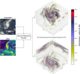
Accurate information on cloud amount vertical structure is crucial for weather monitoring and understanding climate systems. Active sensors from satellites can provide three-dimensional (3D) cloud structure but with limited geographical coverage, passive sensors from satellites have expanded observation coverage but with limited capability on profiling the clouds. Combing active and passive observations from satellites, together with atmospheric reanalysis data, this study proposes a machine learning approach (CLANN, CLoud Amount Neural Network) to construct three-dimensional (3D) cloud amounts at passive observational coverage. Independent validation is conducted for cloud amount estimates derived from combined data of the Advanced Geostationary Radiation Imager (AGRI) onboard Fengyun-4 A and ERA5 using CALIPSO/CALIOP product as reference. The results indicate notable correlations (Pearson's r = 0.73). The cloud-amount-weighted height showed a high consistency in terms of height positioning between CLANN estimations and CALIOP data, with an RMSE of 1.88 km and a Pearson's r of 0.92. Key features such as water vapor band brightness temperature and upper-layer temperature significantly enhanced model accuracy, as revealed by permutation importance analysis. Sensitivity tests highlighted the critical role of the 1.375 μm band in cirrus altitude detection, justifying the model's reliance on daytime observations. Additionally, the 3D statistical results from CLANN in 2019 reveal the seasonal variation details of cloud distribution, further demonstrating its application value in climate analysis.
期刊介绍:
Remote Sensing of Environment (RSE) serves the Earth observation community by disseminating results on the theory, science, applications, and technology that contribute to advancing the field of remote sensing. With a thoroughly interdisciplinary approach, RSE encompasses terrestrial, oceanic, and atmospheric sensing.
The journal emphasizes biophysical and quantitative approaches to remote sensing at local to global scales, covering a diverse range of applications and techniques.
RSE serves as a vital platform for the exchange of knowledge and advancements in the dynamic field of remote sensing.