{"title":"基于多时相平面镜和大地遥感卫星 8 号卫星图像的与 2018 年帕卢地震相关的帕卢-科罗断层行为监测","authors":"Bondan Galih Dewanto , Calvin Wijaya , Ramadhan Priadi","doi":"10.1016/j.rsase.2024.101397","DOIUrl":null,"url":null,"abstract":"<div><div>The Palu-Koro Fault on Sulawesi Island possesses an extensive record of earthquake-related activity, notably the Palu earthquake on September 28, 2018, which was particularly destructive. This study investigates the evolution of this fault by using high-resolution PlanetScope and Landsat 8 Operational Land Imager/Therma Infrared Sensor (OLI/TIRS) images. By investigating the interseismic, coseismic, and postseismic stages of the earthquake's habits, this paper aims to obtain an in-depth understanding of its behavior. The coseismic displacement analysis, which was carried out alongside the optical image correlation technique, indicated major displacements throughout the Palu-Koro Fault, with the largest displacement of roughly 7 m. To ensure the accuracy of the results, internal verification standards, such as a reliability criterion of >30% and a mean structural similarity index (MSSIM) of 1, were used. Landsat 8 imagery was processed using the land surface temperature method to enhance the understanding of the earthquake phases. Prior to the earthquake, the results suggested a rise in temperature, which peaked during the coseismic phase and decreased progressively during the postseismic phase. Intriguingly, the temperature behavior revealed the possibility of using information from remote sensing as an alternative approach to identify the fault distribution in Palu City. Overall, this study demonstrates the utility of remote sensing data for analyzing the dynamics of the Palu-Koro Fault and understanding each stage of the 2018 Palu earthquake. By integrating high-resolution satellite imagery with sophisticated image processing techniques, this paper provides crucial insights into earthquake activity and its impact in this area.</div></div>","PeriodicalId":53227,"journal":{"name":"Remote Sensing Applications-Society and Environment","volume":"37 ","pages":"Article 101397"},"PeriodicalIF":3.8000,"publicationDate":"2024-11-16","publicationTypes":"Journal Article","fieldsOfStudy":null,"isOpenAccess":false,"openAccessPdf":"","citationCount":"0","resultStr":"{\"title\":\"The Palu-Koro fault behaviour monitoring associated with the 2018 Palu earthquake based on the multi-temporal planetscope and Landsat 8 satellite images\",\"authors\":\"Bondan Galih Dewanto , Calvin Wijaya , Ramadhan Priadi\",\"doi\":\"10.1016/j.rsase.2024.101397\",\"DOIUrl\":null,\"url\":null,\"abstract\":\"<div><div>The Palu-Koro Fault on Sulawesi Island possesses an extensive record of earthquake-related activity, notably the Palu earthquake on September 28, 2018, which was particularly destructive. This study investigates the evolution of this fault by using high-resolution PlanetScope and Landsat 8 Operational Land Imager/Therma Infrared Sensor (OLI/TIRS) images. By investigating the interseismic, coseismic, and postseismic stages of the earthquake's habits, this paper aims to obtain an in-depth understanding of its behavior. The coseismic displacement analysis, which was carried out alongside the optical image correlation technique, indicated major displacements throughout the Palu-Koro Fault, with the largest displacement of roughly 7 m. To ensure the accuracy of the results, internal verification standards, such as a reliability criterion of >30% and a mean structural similarity index (MSSIM) of 1, were used. Landsat 8 imagery was processed using the land surface temperature method to enhance the understanding of the earthquake phases. Prior to the earthquake, the results suggested a rise in temperature, which peaked during the coseismic phase and decreased progressively during the postseismic phase. Intriguingly, the temperature behavior revealed the possibility of using information from remote sensing as an alternative approach to identify the fault distribution in Palu City. Overall, this study demonstrates the utility of remote sensing data for analyzing the dynamics of the Palu-Koro Fault and understanding each stage of the 2018 Palu earthquake. By integrating high-resolution satellite imagery with sophisticated image processing techniques, this paper provides crucial insights into earthquake activity and its impact in this area.</div></div>\",\"PeriodicalId\":53227,\"journal\":{\"name\":\"Remote Sensing Applications-Society and Environment\",\"volume\":\"37 \",\"pages\":\"Article 101397\"},\"PeriodicalIF\":3.8000,\"publicationDate\":\"2024-11-16\",\"publicationTypes\":\"Journal Article\",\"fieldsOfStudy\":null,\"isOpenAccess\":false,\"openAccessPdf\":\"\",\"citationCount\":\"0\",\"resultStr\":null,\"platform\":\"Semanticscholar\",\"paperid\":null,\"PeriodicalName\":\"Remote Sensing Applications-Society and Environment\",\"FirstCategoryId\":\"1085\",\"ListUrlMain\":\"https://www.sciencedirect.com/science/article/pii/S2352938524002611\",\"RegionNum\":0,\"RegionCategory\":null,\"ArticlePicture\":[],\"TitleCN\":null,\"AbstractTextCN\":null,\"PMCID\":null,\"EPubDate\":\"\",\"PubModel\":\"\",\"JCR\":\"Q2\",\"JCRName\":\"ENVIRONMENTAL SCIENCES\",\"Score\":null,\"Total\":0}","platform":"Semanticscholar","paperid":null,"PeriodicalName":"Remote Sensing Applications-Society and Environment","FirstCategoryId":"1085","ListUrlMain":"https://www.sciencedirect.com/science/article/pii/S2352938524002611","RegionNum":0,"RegionCategory":null,"ArticlePicture":[],"TitleCN":null,"AbstractTextCN":null,"PMCID":null,"EPubDate":"","PubModel":"","JCR":"Q2","JCRName":"ENVIRONMENTAL SCIENCES","Score":null,"Total":0}
The Palu-Koro fault behaviour monitoring associated with the 2018 Palu earthquake based on the multi-temporal planetscope and Landsat 8 satellite images
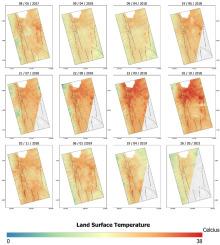
The Palu-Koro Fault on Sulawesi Island possesses an extensive record of earthquake-related activity, notably the Palu earthquake on September 28, 2018, which was particularly destructive. This study investigates the evolution of this fault by using high-resolution PlanetScope and Landsat 8 Operational Land Imager/Therma Infrared Sensor (OLI/TIRS) images. By investigating the interseismic, coseismic, and postseismic stages of the earthquake's habits, this paper aims to obtain an in-depth understanding of its behavior. The coseismic displacement analysis, which was carried out alongside the optical image correlation technique, indicated major displacements throughout the Palu-Koro Fault, with the largest displacement of roughly 7 m. To ensure the accuracy of the results, internal verification standards, such as a reliability criterion of >30% and a mean structural similarity index (MSSIM) of 1, were used. Landsat 8 imagery was processed using the land surface temperature method to enhance the understanding of the earthquake phases. Prior to the earthquake, the results suggested a rise in temperature, which peaked during the coseismic phase and decreased progressively during the postseismic phase. Intriguingly, the temperature behavior revealed the possibility of using information from remote sensing as an alternative approach to identify the fault distribution in Palu City. Overall, this study demonstrates the utility of remote sensing data for analyzing the dynamics of the Palu-Koro Fault and understanding each stage of the 2018 Palu earthquake. By integrating high-resolution satellite imagery with sophisticated image processing techniques, this paper provides crucial insights into earthquake activity and its impact in this area.
期刊介绍:
The journal ''Remote Sensing Applications: Society and Environment'' (RSASE) focuses on remote sensing studies that address specific topics with an emphasis on environmental and societal issues - regional / local studies with global significance. Subjects are encouraged to have an interdisciplinary approach and include, but are not limited by: " -Global and climate change studies addressing the impact of increasing concentrations of greenhouse gases, CO2 emission, carbon balance and carbon mitigation, energy system on social and environmental systems -Ecological and environmental issues including biodiversity, ecosystem dynamics, land degradation, atmospheric and water pollution, urban footprint, ecosystem management and natural hazards (e.g. earthquakes, typhoons, floods, landslides) -Natural resource studies including land-use in general, biomass estimation, forests, agricultural land, plantation, soils, coral reefs, wetland and water resources -Agriculture, food production systems and food security outcomes -Socio-economic issues including urban systems, urban growth, public health, epidemics, land-use transition and land use conflicts -Oceanography and coastal zone studies, including sea level rise projections, coastlines changes and the ocean-land interface -Regional challenges for remote sensing application techniques, monitoring and analysis, such as cloud screening and atmospheric correction for tropical regions -Interdisciplinary studies combining remote sensing, household survey data, field measurements and models to address environmental, societal and sustainability issues -Quantitative and qualitative analysis that documents the impact of using remote sensing studies in social, political, environmental or economic systems