{"title":"揭示全球绿化的真正重要趋势","authors":"Oliver Gutiérrez-Hernández , Luis V. García","doi":"10.1016/j.rsase.2024.101377","DOIUrl":null,"url":null,"abstract":"<div><div>The global greening trend, marked by significant increases in vegetation cover across ecoregions, has attracted widespread attention. However, even robust traditional methods, like the non-parametric Mann-Kendall test, often overlook crucial factors such as serial correlation, spatial autocorrelation, and multiple testing, particularly in spatially gridded data. This oversight can lead to inflated significance of detected spatiotemporal trends. To address these limitations, this research introduces the True Significant Trends (TST) workflow, which enhances the conventional approach by incorporating pre-whitening to control for serial correlation, Theil-Sen (TS) slope for robust trend estimation, the Contextual Mann-Kendall (CMK) test to account for spatial and cross-correlation, and the adaptive False Discovery Rate (FDR) correction. Using AVHRR NDVI data over 42 years (1982–2023), we found that conventional workflow identified up to 50.96% of the Earth's terrestrial land surface as experiencing statistically significant vegetation trends. In contrast, the TST workflow reduced this to 38.16%, effectively filtering out spurious trends and providing a more accurate assessment. Among these significant trends identified using the TST workflow, 76.07% indicated greening, while 23.93% indicated browning. Notably, considering areas (pixels) with NDVI values above 0.15, greening accounted for 85.43% of the significant trends, with browning making up the remaining 14.57%. These findings strongly validate the ongoing global greening of vegetation. They also suggest that incorporating more robust analytical methods, such as the True Significant Trends (TST) approach, could significantly improve the accuracy and reliability of spatiotemporal trend analyses.</div></div>","PeriodicalId":53227,"journal":{"name":"Remote Sensing Applications-Society and Environment","volume":"37 ","pages":"Article 101377"},"PeriodicalIF":3.8000,"publicationDate":"2024-10-11","publicationTypes":"Journal Article","fieldsOfStudy":null,"isOpenAccess":false,"openAccessPdf":"","citationCount":"0","resultStr":"{\"title\":\"Uncovering true significant trends in global greening\",\"authors\":\"Oliver Gutiérrez-Hernández , Luis V. García\",\"doi\":\"10.1016/j.rsase.2024.101377\",\"DOIUrl\":null,\"url\":null,\"abstract\":\"<div><div>The global greening trend, marked by significant increases in vegetation cover across ecoregions, has attracted widespread attention. However, even robust traditional methods, like the non-parametric Mann-Kendall test, often overlook crucial factors such as serial correlation, spatial autocorrelation, and multiple testing, particularly in spatially gridded data. This oversight can lead to inflated significance of detected spatiotemporal trends. To address these limitations, this research introduces the True Significant Trends (TST) workflow, which enhances the conventional approach by incorporating pre-whitening to control for serial correlation, Theil-Sen (TS) slope for robust trend estimation, the Contextual Mann-Kendall (CMK) test to account for spatial and cross-correlation, and the adaptive False Discovery Rate (FDR) correction. Using AVHRR NDVI data over 42 years (1982–2023), we found that conventional workflow identified up to 50.96% of the Earth's terrestrial land surface as experiencing statistically significant vegetation trends. In contrast, the TST workflow reduced this to 38.16%, effectively filtering out spurious trends and providing a more accurate assessment. Among these significant trends identified using the TST workflow, 76.07% indicated greening, while 23.93% indicated browning. Notably, considering areas (pixels) with NDVI values above 0.15, greening accounted for 85.43% of the significant trends, with browning making up the remaining 14.57%. These findings strongly validate the ongoing global greening of vegetation. They also suggest that incorporating more robust analytical methods, such as the True Significant Trends (TST) approach, could significantly improve the accuracy and reliability of spatiotemporal trend analyses.</div></div>\",\"PeriodicalId\":53227,\"journal\":{\"name\":\"Remote Sensing Applications-Society and Environment\",\"volume\":\"37 \",\"pages\":\"Article 101377\"},\"PeriodicalIF\":3.8000,\"publicationDate\":\"2024-10-11\",\"publicationTypes\":\"Journal Article\",\"fieldsOfStudy\":null,\"isOpenAccess\":false,\"openAccessPdf\":\"\",\"citationCount\":\"0\",\"resultStr\":null,\"platform\":\"Semanticscholar\",\"paperid\":null,\"PeriodicalName\":\"Remote Sensing Applications-Society and Environment\",\"FirstCategoryId\":\"1085\",\"ListUrlMain\":\"https://www.sciencedirect.com/science/article/pii/S2352938524002416\",\"RegionNum\":0,\"RegionCategory\":null,\"ArticlePicture\":[],\"TitleCN\":null,\"AbstractTextCN\":null,\"PMCID\":null,\"EPubDate\":\"\",\"PubModel\":\"\",\"JCR\":\"Q2\",\"JCRName\":\"ENVIRONMENTAL SCIENCES\",\"Score\":null,\"Total\":0}","platform":"Semanticscholar","paperid":null,"PeriodicalName":"Remote Sensing Applications-Society and Environment","FirstCategoryId":"1085","ListUrlMain":"https://www.sciencedirect.com/science/article/pii/S2352938524002416","RegionNum":0,"RegionCategory":null,"ArticlePicture":[],"TitleCN":null,"AbstractTextCN":null,"PMCID":null,"EPubDate":"","PubModel":"","JCR":"Q2","JCRName":"ENVIRONMENTAL SCIENCES","Score":null,"Total":0}
Uncovering true significant trends in global greening
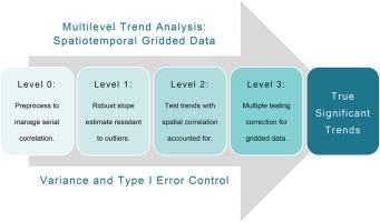
The global greening trend, marked by significant increases in vegetation cover across ecoregions, has attracted widespread attention. However, even robust traditional methods, like the non-parametric Mann-Kendall test, often overlook crucial factors such as serial correlation, spatial autocorrelation, and multiple testing, particularly in spatially gridded data. This oversight can lead to inflated significance of detected spatiotemporal trends. To address these limitations, this research introduces the True Significant Trends (TST) workflow, which enhances the conventional approach by incorporating pre-whitening to control for serial correlation, Theil-Sen (TS) slope for robust trend estimation, the Contextual Mann-Kendall (CMK) test to account for spatial and cross-correlation, and the adaptive False Discovery Rate (FDR) correction. Using AVHRR NDVI data over 42 years (1982–2023), we found that conventional workflow identified up to 50.96% of the Earth's terrestrial land surface as experiencing statistically significant vegetation trends. In contrast, the TST workflow reduced this to 38.16%, effectively filtering out spurious trends and providing a more accurate assessment. Among these significant trends identified using the TST workflow, 76.07% indicated greening, while 23.93% indicated browning. Notably, considering areas (pixels) with NDVI values above 0.15, greening accounted for 85.43% of the significant trends, with browning making up the remaining 14.57%. These findings strongly validate the ongoing global greening of vegetation. They also suggest that incorporating more robust analytical methods, such as the True Significant Trends (TST) approach, could significantly improve the accuracy and reliability of spatiotemporal trend analyses.
期刊介绍:
The journal ''Remote Sensing Applications: Society and Environment'' (RSASE) focuses on remote sensing studies that address specific topics with an emphasis on environmental and societal issues - regional / local studies with global significance. Subjects are encouraged to have an interdisciplinary approach and include, but are not limited by: " -Global and climate change studies addressing the impact of increasing concentrations of greenhouse gases, CO2 emission, carbon balance and carbon mitigation, energy system on social and environmental systems -Ecological and environmental issues including biodiversity, ecosystem dynamics, land degradation, atmospheric and water pollution, urban footprint, ecosystem management and natural hazards (e.g. earthquakes, typhoons, floods, landslides) -Natural resource studies including land-use in general, biomass estimation, forests, agricultural land, plantation, soils, coral reefs, wetland and water resources -Agriculture, food production systems and food security outcomes -Socio-economic issues including urban systems, urban growth, public health, epidemics, land-use transition and land use conflicts -Oceanography and coastal zone studies, including sea level rise projections, coastlines changes and the ocean-land interface -Regional challenges for remote sensing application techniques, monitoring and analysis, such as cloud screening and atmospheric correction for tropical regions -Interdisciplinary studies combining remote sensing, household survey data, field measurements and models to address environmental, societal and sustainability issues -Quantitative and qualitative analysis that documents the impact of using remote sensing studies in social, political, environmental or economic systems